


BISAC NAT010000 Ecology
BISAC NAT045050 Ecosystems & Habitats / Coastal Regions & Shorelines
BISAC NAT025000 Ecosystems & Habitats / Oceans & Seas
BISAC NAT045030 Ecosystems & Habitats / Polar Regions
BISAC SCI081000 Earth Sciences / Hydrology
BISAC SCI092000 Global Warming & Climate Change
BISAC SCI020000 Life Sciences / Ecology
BISAC SCI039000 Life Sciences / Marine Biology
BISAC SOC053000 Regional Studies
BISAC TEC060000 Marine & Naval
The planning of exploration and socio-economic development of coastal regions is impossible without the knowledge of coastal processes and scientifically based forecast of the evolution not only the shoreline, but the submerge slope also. Laboratory of lithodynamic and geology of the Southern Branch of the P.P. Shirshov Institute of Oceanology RAS since 2010 surveys bottom topography within Anapa Bay-Bar. Along Anapa Bay-Bar the presence of two longshore underwater bars is clearly observed. The first underwater bar is narrower than another one. His width is up to 40 m and it is located at the depth of 1.5-2.0 m. The second underwater bar is wider (up to 150 m) and it is located at the depth of 3.5-4.0 m. The both bars have the height, approximately, of 2.0-2.5 m. Both bars are well expressed in the central part of Anapa spit. Modern dynamics of the submerge slope changes will be considered in the paper.
Anapa Bay-Bar, evolution of the submerge slope, longshore underwater bars.
I. Introduction
The Anapa bay-bar is an accumulative sand body approximately 47 km long, located in the North-West part of the Russian coast of the Black Sea. The Anapa bay-bar is a narrow spit (its width ranges from 80 m in the northern part to 1.5 km in the south) which isolates a system of lagoons from the Black Sea (Fig. 1). The entire bay-bar and especially its southern part with sand beaches 50-200 m wide is intensely used in recreation.
The Anapa bay-bar is a polygenetic accumulative coastal form, combining in its development the properties of an accumulative body of the barrier type with the transversal motion of sediments and longitudinal type with alongshore displacement. The configuration of the shore and topography of the shelf actually formed the closed lithodynamic system of the Anapa bay-bar (Fig. 1), which has a form of a concave arc [1, 2].
The first scientific data on the geological and geomorphological structure of the Anapa bay-bar appeared in the 19th century. In 1838-1865, E. Verneil and I. Guyo, and others considered the problems of the geological structure and topography forms of the Anapa region [3]. Beginning from 1948, V.V. Longinov, A.A. Popov, E.N. Nevessky, E.N, Egorov and other carried out scientific researches in the region of the Anapa bay-bar. A publication by V.P. Zenkovich [4] is one of the most complete descriptions of the Anapa bay-bar. N.A. Aibulatov repeatedly addressed the Anapa bay-bar as an object of the scientific research. The monograph by Ya.A. Izmailov published in 2005 [3] presents a paleo-geographical reconstruction of the history of Anapa bay-bar formation based on the analysis of the geological and geomorphological data. Since 2010, the scientists of the Southern Branch of the P.P. Shirshov Institute of Oceanology of the RAS have been conducting annual multidisciplinary investigations of the Anapa bay-bar [5]. Current state of the Anapa bay-bar coastal zone more detail described in the papers of R.D. Kosyan, et al [1, 2, 5, 6, 7].
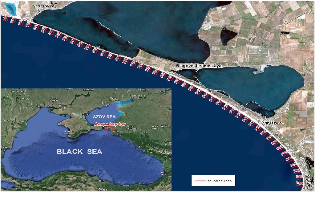
Fig. 1. The scheme of the Anapa bay-bar and sounding lines for measurement of depths.
II. Methods and Results
The issue of the underwater sand bars formation and dynamics is not new for the Black Sea coast. However, a complete theory of formation and dynamics of the underwater sand bars did not create and also a method for the forecasting of the natural phenomena, like the underwater sand bars, did not developed. While the issues of forecasting dynamics and control of the submerge slope are very important and practical interest to these issues are actual up to now.
The submerge slope along Anapa bay-bar is slightly convex, as for the area of underwater sand bars should be a slight increase in the incline. The average slope to 5 m depth is 0.01; followed to a depth of 5-12 m slope is 0,015-0,018, and then slope sharply decreased to 0.003 at depths exceeding 12-15 m.
The underwater bars are relatively stable. Their moving either to the beach or to the sea during a wide variety of storms is negligible. Three underwater bars were discernible in the studied area according to data of 1955 [4]. The tops of the underwater bars in 1955 were located from the shoreline at 63-84, 157-177 and 272-319 meters. The depths over the tops of the bars were, respectively, 0.9-1.4, 2.0-2.3 and 3.9-4.0 m. The middle bar was the most well marked for height and was more constantly in comparison with first and second bars. The first bar (located closer to the shore) was quite movable - sometimes this bar was closer to the shoreline, sometimes it was become further. The third bar was the lowest.
At the present time, there are two bars only, identified according to observation of 2010-2015. The underwater bars are at the distances of 100-120 and 250-350 meters from the shoreline. Depths over the tops of the bars are 1,5-2,2 and 3,8-5,0 m. The first bar is more steep and narrow in comparison with the second one, the height of the both bars are average out at 1-2 m (Fig. 2-12).

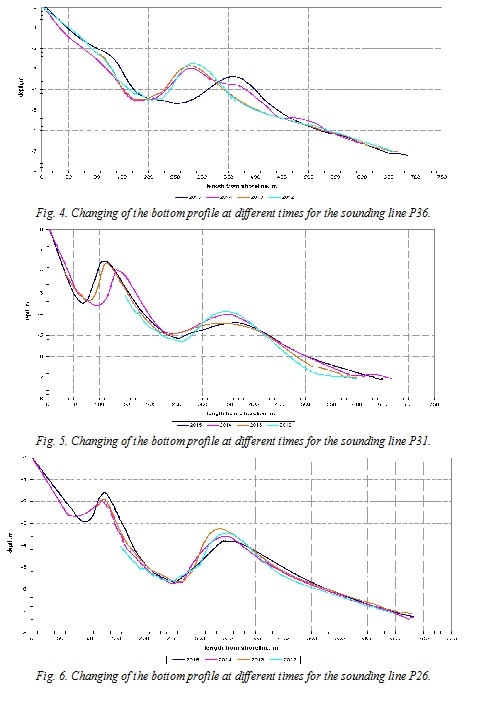
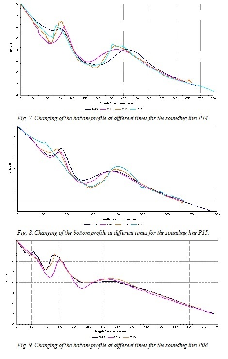
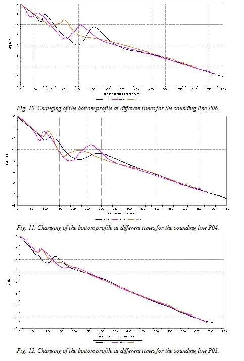
The bars gradually became smaller, lower and closer in the direction from the central part of Anapa bay-bar to its edges, according to data of 1955 [4]. The observations of 2010-2015 showed the same trend of the longshore underwater bars changes.
The contour of the first underwater bar has an influence on the shoreline contour. A specific cape was formed opposite this bar (Fig. 13). The water is usually catching up between two such capes during storms. The undertow currents formed and washed the hollow in the underwater bar surface. Accordingly, the first bar has fairly frequent bends and breaks. The shoreline contour is changing, when the waves are approaching to the shore with the narrow angle and the capes are migrating along the shoreline. The orientation of the underwater bars is changing, when the west storms are dominate. The first underwater bar is disintegrated to few small bars in the eastern and central parts of the Anapa bay-bar. These small bars have usually narrow angles with the shoreline (Fig. 13). However, the position of the underwater bars is restored after several southern storms.
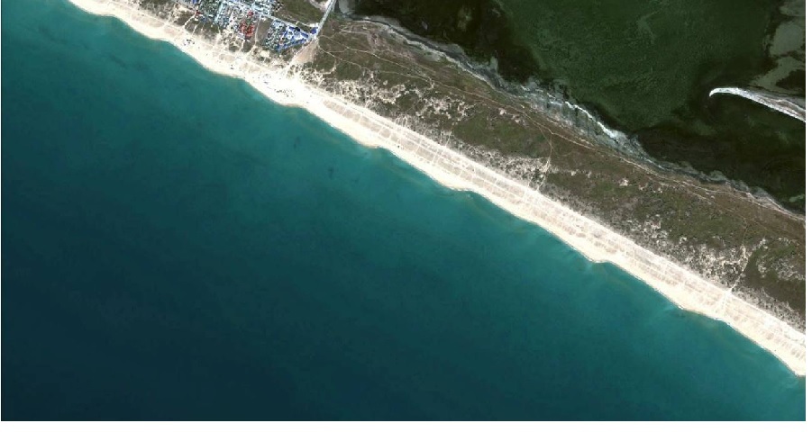
Fig. 13. The capes formed opposite the first broken underwater bar (Modified from [7]).
As can be seen from Figures 2-12 the position of underwater bars relative to each other for 2012-2015 has changed slightly. The most stable underwater bars are located in the central part of the Anapa bay-bar (Fig. 5-7). On the eastern and western ends of the Anapa bay-bar the underwater bars change its shape, height and distance from the coastline in different years (Fig. 2-4 and 8-12). These observations demonstrate significant instability of the underwater relief near the capes that corresponds to the basic concepts of the coastal zone development [4].
III. Conclusions
Laboratory of lithodynamic and geology of the Southern Branch of the P.P. Shirshov Institute of Oceanology RAS since 2010 surveys bottom topography within Anapa Bay-Bar. Along Anapa Bay-Bar the presence of two longshore underwater bars is clearly observed. The first underwater bar is narrower than another one. His width is up to 40 m and it is located at the depth of 1.5-2.0 m. The second underwater bar is wider (up to 150 m) and it is located at the depth of 3.5-4.0 m. The both bars have the height, approximately, of 2.0-2.5 m. Both bars are well expressed in the central part of Anapa spit. During calm weather of the summer period the submerged slope becomes less steep as compared with the profile generated during winter storms. It seems necessary to link the main changes in the morphology and morphometry of the underwater bars with different storms and sediments grain size to make accurate predictions of the bottom relief reformation. It is also necessary to make some series sounds of the submerge slope before and after the different storms.
IV. Acknowledgments
This work was initialized by the Russian Foundation for Basic Research (Project no. 16-35-00533). The performing of experimental works was supported by the Russian Science Foundation, project no. 14-17-00547. The calculations and analysis of the results were supported by the Russian Science Foundation, project no.14-50-00095.
1. V.V. Krylenko, R.D. Kos’yan, A.D. Kochergin, "Regularities of the Formation of the Granulometric Composition of the Bottom and Beach Deposits of the Anapa Bay-Bar" Oceanology 51(1), 1061-1071 (2011).
2. R.D. Kosyan, S.B. Kuklev, V.V. Krylenko, "Brittle equilibrium of the Anapa bay-bar" Priroda 2, 2012, pp. 19-28. (in Russian).
3. Ya.A. Izmailov, "Evolutionary Geography of the Azov and Black Sea Coasts. Anapa Bay-Bar", 2005, pp. 1-174. (in Russian).
4. V.P. Zenkovich, "Coasts of the Black and Azov Seas", 1958, 150 p. (in Russian).
5. R.D. Kosyan, Yu.N. Goryachkin, V.V. Krylenko, V.V. Dolotov, M.V. Krylenko, E. A. Godin, "Crimea and Caucasus Accumulative Coasts Dynamics Estimation using Satellite Pictures" Turkish Journal of Fisheries and Aquatic Sciences 12, 2012, pp. 385-390.
6. M. Krylenko, V. Krylenko, R. Kosyan “Accumulative coast dynamics estimation by satellite camera records” Third international conference on remote sensing and geoinformation of the environment (RSCY2015). Book Series: Proceedings of SPIE. Vol. 9535. Hadjimitsis, DG; Themistocleous, K; Michaelides, S; et al, 2015, P. 95351K. http://dx.doi.org/10.1117/12.2192495.
7. R.D. Kosyan, V.V. Krylenko, “Modern status of marine accumulative shores of Krasnodar region and their use”, Nauchnyi Mir, Moscow, 2014, 256 p. (in Russian).