


Россия
BISAC NAT010000 Ecology
BISAC NAT045050 Ecosystems & Habitats / Coastal Regions & Shorelines
BISAC NAT025000 Ecosystems & Habitats / Oceans & Seas
BISAC NAT045030 Ecosystems & Habitats / Polar Regions
BISAC SCI081000 Earth Sciences / Hydrology
BISAC SCI092000 Global Warming & Climate Change
BISAC SCI020000 Life Sciences / Ecology
BISAC SCI039000 Life Sciences / Marine Biology
BISAC SOC053000 Regional Studies
BISAC TEC060000 Marine & Naval
Coastal zone dynamics is especially interesting for interdisciplinary researchers. This is due to general retreat of the coast of the Western Crimea and the fast response in the beach ar-ea. This justifies the need for monitoring of morphodynamic processes in the coastal zone of Crimea with the aim of qualitative and quantitative assessments of modern coastal trans-formation, as well as forecasts of possible changes. XBeach model has been used to simulate dynamics of waves and currents, sediment transport and changes in bottom topography, as well as the processes of drying and flooding of coastal areas. Erosion and sedimentation processes for the bottom sediments of the coastal zone of the Western Crimea have been numerically studied. The bottom profile has been reconstructed on the basis of bathymetric investigations in the coastal zone of the Western Crimea. Numerical simulations have been performed for various parameters of the bed composition and wind waves. Two fractions of bottom sediments have been considered for numerical experiments. The obtained results show that XBeach model can be successfully applied to simulate the bed profile evolution and changes in bottom sediment fractionation.
Black Sea, Western Crimea, coastal zone, XBeach model, sediment transport and fractionation modelling.
I. INTRODUCTION
In shallow waters and coastal zones, waves and currents support redistribution of clastic material and subsoils presented in the form of suspended load and bed load. This results in erosion and accumulation of bottom sediment, affects transformation of bottom topography and changing coastlines [1]. While waves propagate from outer limits of the nearshore zone towards the shore they increasingly affect bottom sediments, especially in processes wave shoaling and breaking. In one to two day of coastal storm, a radical restructuring of the cross-shore profile is observed. Material is carried away from the beach and the fine fraction is set in motion. Changes in the intensity and spatial distribution of sediments transport parameters largely determine the main trends of reshaping the underwater coastal slope and coastline.
The coastal zone, investigated in this paper, extends from the shoreline to the depth of water where wave motion ceases to affect the seabed. Modelling will provide critical information on how changes of the wave period influence the redistribution of sediments with various grain sizes. For Kalamitskiy Gulf beaches degradation problem is very relevant. Therefore, it is necessary to develop robust tools that enable accurate prediction of coastal system responses to storms in order to improve coastal management.
Kalamitskiy Gulf is situated at the west coast of the Crimean peninsula (Fig. 1). Wide and straight beaches are known for their clean and soft golden sand, clear sea water and gently sloping bottom of the gulf. The study area is located in the northern part of the gulf and extends approximately 600 meters longshore and 500 me

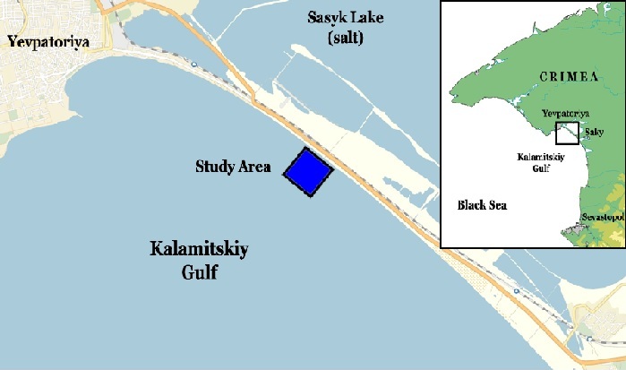
Fig.1. Area of investigation showing the location of the study area chosen for modelling
Sandy beaches constantly adjust their morphology in response to changing hydrodynamic conditions. The Black sea is a tideless basin and sediment transport in littoral zone of Kalamitskiy Gulf induced primarily by wind waves. Anthropogenic influences, including dam construction during the 20th century, have had significantly affected the natural sedimentary dynamics in the Kalamitskiy gulf. As a result, the northern part of the gulf has become limited in sediment supply. Seasonal variations in wave parameters results in specific winter and summer profiles in nearshore zone.
The position of shoreline over the last decades is quite stable in the study area [2]. But, during strong storms, local beaches can be extremely dynamic, with the potential up to tens of meters of shoreline recession or propagation over hours to days. If so, waves can reach coastal constructions and cause a damage to infrastructure.
The purpose of this paper is to apply the XBeach model (1D) for modelling of changes of the beach and nearshore morphology within the region of Kalamitskiy Gulf at the west coast of Crimea. As sediments in the coastal area are presented by a variety of coarse and fine fractions [3], we used data from actual studies of sediments from the Kalamitskiy Gulf.
II. MODEL IMPLEMENTETION
The XBeach model [4] is applied in a 1D cross-shore setting with a constant grid size 1m. All calculations carried out for the storm period of about 48 hours. On the first stage of model adaptation to the region of Kalamitskiy Gulf the approximation of the summer profile is used as initial profile for numerical simulations (Fig. 2a).
Wave boundary conditions were implemented as time series of sea state (instant=jonswap) with perpendicular direction to the coast. The significant wave height Hs was set at 2 m. The wave peak period Tp = 6, 8 and 10 s. Further, default settings were applied, except from the avalanching parameters. The critical slope for avalanching above water (dryslp) and the critical slope for avalanching below water (wetslp) had values 0.1. The two sediment classes (ngd = 2) were considered (see Table 1).
Table 1. Grain size of the sediment fractions [mm]
|
Coarse fraction |
Fine fraction |
||
|
d50(1) |
d90(1) |
d50(2) |
d90(2) |
|
0.635 |
1.370 |
0.115 |
0.175 |
III. RESULTS AND DISCUSSION
Wave period and initial partitioning of fractions are two input parameters, which have been varied in numerical experiments. The evolution of the bed profile and redistribution of sandy factions in the littoral zone have been investigated in numerical simulations for six scenarios. We illustrate further mostly the results of experiments for the wave period of 8 seconds because all results are qualitatively similar.
The evolution of the profile for all types of the used wave conditions and sediment fractionations results in beach erosion and slope flattening in the foreshore zone. Eroded material moves in the seaward part of the nearshore zone to accumulate as a bar. With increasing of the wave period, the band of bottom topography is expanded. The beach erosion boundary is shifted toward the shore, the bottom deformation absolute values are grown in the both erosion and accumulation area (Fig. 2b). The largest volume of sediment movement and accordingly the bottom relief change occur at the base of the ledge erosion.
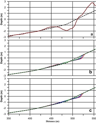
Fig. 2. (a) Measured profile (ruby red line) and its approximation (black dotted line). (b) Initial bed level for BC1 (black dotted line), bed level for Tp = 6s after 48h (green line), bed level for Tp = 8s after 48h (blue line), bed level for Tp = 6s after 48h (red line). (c) Initial bed level for BC1 (black dotted line), bed level for Tp = 8s after 3h (green line), bed level for Tp = 8s after 24h (blue line), bed level for Tp = 8s after 48h (red line).
The rate of shoreline retreat changes over time. The highest values are observed at the start of the storm and they reach about 1 meter per hour. By the end of simulation, the beach erosion rate is significantly reduced and does not exceed 0.1 m/h (Fig. 2c).
Position of zero sea-level mark for wave period of 8 seconds is shifted shoreward by 11 m for BC1 and by 8.5 m for BC2 (Fig. 3c, 4c). The erosion layer thickness increases with decreasing of D50. Using of avalanching parameters in numerical experiments results in erosion of the beach profile above water. The width of the erosion zone for the aerial part of the beach is about 4 m.
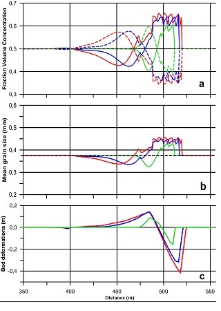
Fig. 3. (a) Distribution of the fraction volume concentration for BC1(Hs = 2m, Tp = 8s), initial fraction volume concentration (black dotted line), fraction volume concentration after 3h (coarse fraction – green line, fine fraction – green dotted line), fraction volume concentration after 24 h (coarse fraction – blue line, fine fraction – blue dotted line), fraction volume concentration after 48h (coarse fraction – red line, fine fraction – red dotted line); (b) Distribution of mean grain size (D50) for BC1(Hs = 2m, Tp = 8s), initial D50 (black dotted line), D50 after 3h (green line), D50 after 24 h (blue line), D50 after 48h (red line); (c) Bed deformations for BC1 (Hs = 2m, Tp = 8s), bed deformation after 3h (green line), bed deformation after 24 h (blue line), bed deformation after 48h (red line).
At the beginning of storm, the bar profile is rather symmetric. Exposure of waves, the position of the bar crest moves seaward, and then remains stable. During this time, the height of the bar crest is also stable. At the same time, the bar width essentially depends on the particle size distribution. The slope of the bar towards the shore has a greater inclination and shorter length than the backcourt slope. This asymmetry increases over the period of wave action. Sandy material moves seaward and leads to an increase in the width of the bar and its more acclivous slope. The increase of the period of wave influence changes the amount of transported material, causing the increase in the height and width of the bar.
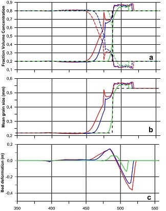
Fig. 4. (a) Distribution of the fraction volume concentration for BC2 (Hs = 2m, Tp = 8s), initial fraction volume concentration (black dotted line), fraction volume concentration after 3h (coarse fraction – green line, fine fraction – green dotted line), fraction volume concentration after 24 h (coarse fraction – blue line, fine fraction – blue dotted line), fraction volume concentration after 48h (coarse fraction – red line, fine fraction – red dotted line); (b) Distribution of mean grain size (D50) for BC2 (Hs = 2m, Tp = 8s), initial D50 (black dotted line), D50 after 3h (green line), D50 after 24 h (blue line), D50 after 48h (red line); (c) Bed deformations for BC2 (Hs = 2m, Tp = 8s), bed deformation after 3h (green line), bed deformation after 24 h (blue line), bed deformation after 48h (red line).
Redistribution of individual grain fractions of sediments starts immediately with the wave action. The results of simulations for both BC1 and BC2 types reveal movements of coarser particles towards the coast and movements of finer particles seaward (Fig. 3a, 4a). At the same time, the mean diameter of grain size D50 grows in the area of beach erosion and coastline retreat (Fig. 3b, 4b). With increasing the waving exposure, the total width of D50 changing band is expanded. As the result, a stable zone is formed near the coastline, in which the coarser sediments are concentrated. This zone is expanded mainly due to displacement of the water boundary due to erosion of the beach. Results of modeling indicate that the width of this zone does not depend on the initial distribution of grain fractions. Only wave parameters are important.
Processes of sediments redistribution for BC1 and BC2 reveal significant differences in the seaward part of the profile. The initial distribution of the sand fractions by the type BC1 is extremely rare in the nature. Homogeneous conditions may occur mainly for artificial beach nourishment. As a result, after 48 hours of storm for BC1, the distribution of D50 significantly different in comparison to initial (Fig. 3b). Deposition of fine factions take place in the seaward part of the profile . An increasing number of fine particles and decreasing D50 from 0.375 to 0.337 mm are observed. The offshore part of the profile is characterized by differentiation and transition to the originally specified distribution of sediments.
The initial distribution of sand fractions by type BC2 is similar to the field observations in the coastal zone of the Kalamitskiy Gulf. In this case, the initial sediment distribution is largely preserved in the seaward part of the profile (Fig. 4b). A monotonic decrease of D50 values is formed in the transition zone. Within the area of coarse material, the mean grain size increases from 0.53 to 0.57 mm. This demonstrates that redistribution of sediments under the wave action is insignificant in case the initial sediment composition is close to the nature.
IV. CONCLUSION
The XBeach model has been applied for the region of the Kalamitskiy Gulf at the west coast of Crimea. The obtained results show that the XBeach model can successfully simulate the bathymetry evolution and sand fraction redistribution.
The results of numerical experiments indicate that beach erosion and slope flattening in foreshore zone occur for all types of used wave conditions and sediment fractions distributions.
The increase of the period of wave action changes the amount of transported material, resulting in lengthening of the reformation zone and rising in the height and width of the forming bar. The bar width depends on the initial particle size distribution.
A sufficiently stable zone is formed near the coastline, in which the coarser sediments are concentrated. Yet, redistribution of sediments is insignificant in case the initial composition is close to the nature.
1. V.A. Ivanov, V.V. Fomin, “Mathematical Modelling of Dynamical Processes in the Sea-Land Area”, Kyiv: Akademperiodyka, 2010, 286 p.
2. Yu. N. Goryachkin, V.V. Dolotov “Variations of shoreline of accumulative coast of the West-ern Crimea”, Ecological safety of coastal and shelf zones and comprehensive use of shelf re-sources: Collected scientific papers. 2011, Iss. 25, vol. 1, pp. 8 - 18. (in Russian).
3. K.I. Gurov, E.I. Ovsyany, E.A. Kotel’yanets, S.K. Konovalov, “Geochemical characteristics of bottom sediments in the Kalamita Bay water area in the Black Sea”, Marine Hydrophysical Journal, 2014, vol. 5, pp. 69 - 80. (in Russian).
4. “XBeach Manual”, Deltares, UNESCO-IHE Institute of Water Education and Delft Universi-ty of Technology, 2015, 138 p.