


BISAC NAT010000 Ecology
BISAC NAT045050 Ecosystems & Habitats / Coastal Regions & Shorelines
BISAC NAT025000 Ecosystems & Habitats / Oceans & Seas
BISAC NAT045030 Ecosystems & Habitats / Polar Regions
BISAC SCI081000 Earth Sciences / Hydrology
BISAC SCI092000 Global Warming & Climate Change
BISAC SCI020000 Life Sciences / Ecology
BISAC SCI039000 Life Sciences / Marine Biology
BISAC SOC053000 Regional Studies
BISAC TEC060000 Marine & Naval
The Gulf of Kalamita is located in the Black Sea off the west coast of the Crimea and is known to be a major recreational area. However, in the last 30 years, its famous sandy beaches have drastically degraded. Degradation of sandy beaches was expressed in erosion of the coastal line (30-70 m) and reduction of the total area of beaches; disappearance of sand in a number of ar-eas in the near-shore zone and openings of marl; sharp increase of fragments of limestone in the composition of beaches. In the last 60 years, the level of the Black Sea has risen by 14 cm. Only this factor, as the calculations show, has caused about 15 mln m3 deficiency of deposits. Accord-ing to direct observations, shoreline response to changes in the sea level at the inter-annual scale changes comproses 0,3 m per 1 cm. Climate changes in trajectories of passing cyclones have resulted in a 2-3 times increase in storm activity over the past 30 years. The contribution of natural factors into the shoreline changes do not exceed 10-15% according to our estimates. The main contribution is related to the background and point anthropogenic impacts. The first group includes overall reduction of sediment in the sea due to construction of reservoirs, cliffs closing with concrete embankments, reducing populations of benthic mollusks for various rea-sons, etc. The second group includes construction of hydraulic structures which do not address lithodynamics peculiarities in particular stretches of coastline.
Crimea, Kalamita gulf, degradation of sandy beaches, anthropogenic impacts.
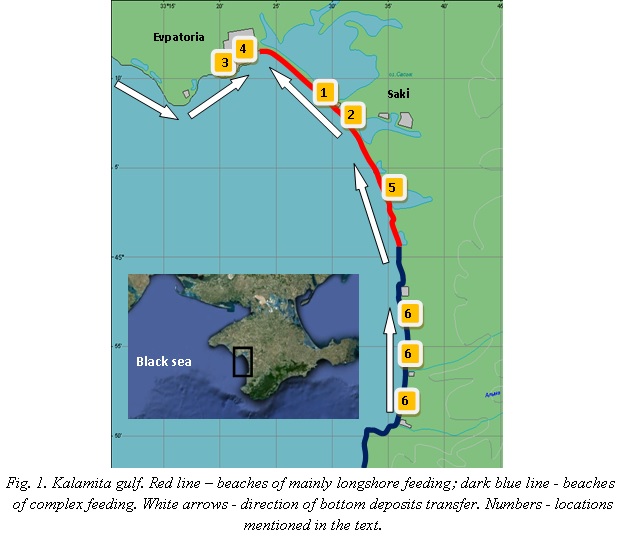
Kalamita gulf is located in the Black Sea at the Western coast of the Crimean peninsula (fig. 1). The gulf is shallow, its depths increase gradually from the coast to the sea, and the maximum depth is about 30 m. In the Northern part of the gulf, the coast is low and sandy. In the Southern part, it is high, steep, formed by clays. At the coast of the gulf, there are many salty lakes separated from the gulf by sandy bay-bars. The lakes are of medical value. On the coast of the gulf the cities of Evpatoria (120,000 inhabitants), Saki (25,000) and a number of smaller settlements are located. The water area in the Southern part of the gulf is considered to be a natural object with unique water and land ecosystems and it is a reserve.
Kalamita gulf is known to be a major recreational zone of Crimea. Evpatoria is the most famous resort. The city was founded by the Greeks in VI century B.C. and it was called Kerkinitida (Κερκινίτις, Kerkinitis). In the XV century it was renamed as Gezlev (Gözleve) and it was governed by the Crimean khanate. In the end of the XVIII century it became a part of Russia and it got a new name, Evpatoria, in honour of the tsar of the Greek-Persian state Mitridat VI - Evpator (134-63 BC).
Up to the XX century, trade, fishery and salt extraction from the lakes were the basic occupations of those who inhabited the region. In this period, the population never exceeded 25,000 people. In the beginning of the XX century, resorts started to develop. Two factors triggered such development: medical dirt and brine in the salty lakes and the famous sandy beaches. Besides this, favorable climate in combination with shallow relief of the coastal line has created good conditions for development of the resorts.
By the end of the XX century, over 70 sanatoria worked only in Evpatoria, about 1,0 million visitors had a rest in the region annually. The only analogue to the quality and extent of
Evpatorian beaches on the Black Sea is "Golden Sands" in Bulgaria. However, during the last 30 years the sandy beaches have sharply degraded. Degradation of beaches was expressed in:
- erosion of the coastal line (in some areas up to 30-70 m) and reduction of the total area of beaches;
- disappearance of a number of sand areas in the water level zone and opening of clay adjournment;
- sharp increase of fragments of bay-bars in the composition of beaches.
All this has considerably worsened the recreational attractiveness of the resort, which causes reasonable alarm among the city administration and heads of health resorts.
Before we pass to the reasons which have caused the degradation of beaches, we will mention some features of the coast structure and lithodynamics of the Kalamita gulf [1].
In the Northern part of the gulf the coast is accumulative, bay-bars of salty lakes are generated here. Beaches are formed mainly by fine-grained sand. In some places deposits mainly consist of fragments of modern cockleshells which are thrown out from the sea-bottom. The Southern part of the accumulative coast is formed by deposits which consist of 50 % pebbles and 50 % sand. The pebble part consists of alluvium brought by the rivers and temporary waterways of South-Western Crimea. The rest is formed by the product of coast destruction (ancient alluvial plain occurs in the cliffs of the Southern part of the Kalamita gulf). In the Southern part of the Kalamita gulf, the coast is abrasive with clay cliffs up to 15 m high.
In the Northern part, beaches are mainly formed by beach drifts (their mean annual direction is from the South to the North). In the Southern part of the gulf, the beaches have a complex supply (destruction of benches and cliffs, river deposits). According to the observational data, on average about 1 million m3 arrive from cliffs to the coastal zone annually. The specific value of driftage is 21 m3/m per year. Abrasion of benches is especially widely spread in the Southern part of the region. It is active up to 12 m deep, which was defined by direct observation with bottom reference points. Abrasion of coast and bottom combined delivers about 1,5 million m3/year sedimentary material to the sea. Only about 0,3 million m3 of this amount make the beach-forming fractions which remain in the coastal zone. The rest of the sedimentary material is taken to the sea in the form of suspension.
In our opinion, anthropogenous activity has had the greatest influence on changes in the coast line in the Kalamita gulf [2]. As historical photos show, in the end of the XIX century, there was a vast beach in the central part of Evpatoria. Storm surges made certain problems; therefore in the beginning of the XX century the first coast protecting construction in the form of an inclined wall about 500 m long was erected in the city centre. Further dynamics of beaches in this part of the city depended on presence or absence of this wall which was continually destroyed and restored. The most significant reconstruction of the downtown quay was made in 1968 – 1972. After the reconstruction was completed, it represented a vertical concrete wall with a breakwater 1,8 km long. Within only one year, beaches in the central part of the city have completely disappeared, and the depths in the Evpatoria bay have increased by 1 m on average. In other words, the stock of deposits was sharply reduced. The earlier measurements of depths in 1836, 1896 and 1923 showed that the bottom relief there had hardly changed.
In the early 1950-ies a sand open-cast mine was put into service on the bay-bar of the lake Sasyk (fig. 1, number 1). At that time nobody thought about the possible consequences. As the sand was extracted, the closing dike, which separated the open-cast mine from the sea, narrowed and under the influence of storms it curved towards the open-cast mine. At the coast of the Kalamita gulf a considerable bend of the coastal line was formed and a tendency to beach reduction was outlined in the sites adjoining to the open-cast mine. There was a real danger of increase in filtration of the sea waters into the lake and eventually a loss of medical properties of the dirt. Because of this danger, the open-cast mine on the bay-bar was closed and moved to the underwater slope of the sea (fig. 1, number 2). Nowadays, the site of the bay-bar where sandy dunes used to be is a bog.
While the open-cast mine was in action, over 15 million m3 sand was extracted on the underwater slope in 1960-ies, in the period of about 10 years. During this period the beach drift was almost completely intercepted. The filling of the underwater open-cast mine with the sand from the adjoint sites has caused considerable erosion in the coastal line (up to 11 m per year). In some places it has receded by 200-220 m. Open-cast mine was closed soon after it started to affect the beaches of Evpatoria, but it was too late.
In the 1970-ies a new phase of drama with the beaches of the Kalamita gulf began. Several factors came to action at once.
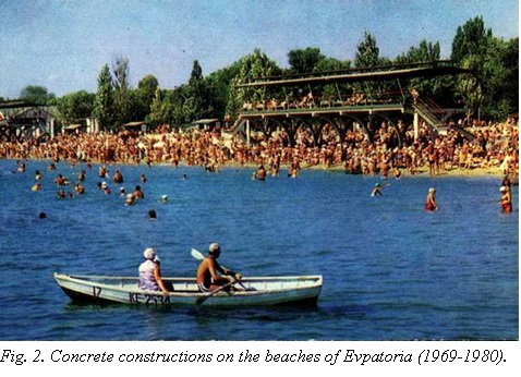
1. At this time, a medical procedure “sleep next to the sea” became popular. In order to fulfill this requirement, massive two-storeyed constructions with powerful ferro-concrete basements were built right on the sandy beaches (fig. 1, number 3; fig. 2). However, they have not justified their purpose. On the contrary, beaches began to recede quite quickly, washing away the basements. 10 years later, these buildings were pulled down.
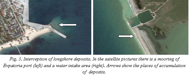
2. On Quarantine cape a 200 m long pier was built for the needs of port; it was a monolithic concrete construction (fig. 1, number 4, fig. 3, a). Migration of deposits has changed and an extensive shallow was formed at the East side of the pier. In order to maintain the constant depth on the waterway, bottom dredging started. The sand was dumped into the sea according to the existing notion about the direction of movement of deposits. However, this notion was not proved. As a result, to the West of the port pier, the coastal line started to recede quickly, and the sand almost disappeared from the bottom. Nowadays, the beaches of this part of the city are the most troublesome.
3. At the same time on the bay-bar at the lake Kyzyl-Jar, a hydraulic engineering construction was built and it blocked the deposit drift (fig. 1, number 5; fig. 3, b). To the South from this construction, the material began to accumulate (mean annual speed of accumulation was 7,5 m/year), and the coastal line was put forward by length of this hydraulic engineering construction (120 m). To the North from the water intaking construction, intensive abrasion began, with the mean annual speed of 3,7 m/year.
4. During the same period, water basins were constructed on the basic rivers of the Western Crimea. As a result, the firm drain of the rivers was reduced by almost ten times.
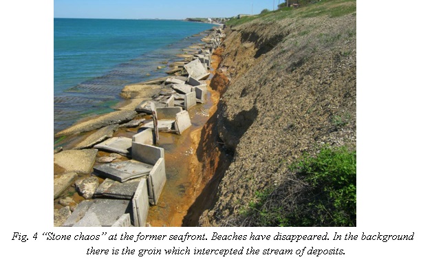
5. In the Southern part of the Kalamita gulf quays in the form of ladders were built in order to create “aesthetic landscape”. Due to such fastening of coast by concrete constructions, wave processing of cliffs was reduced and, hence, the amount of firm deposits in the coastal zone was reduced as well. It should be mentioned that beaches before such constructions quickly disappeared, and the constructions have completely collapsed by now. The basic problem now is their recycling, since they are “stone chaos” (fig. 1, number 6, fig. 4).
Among other factors of anthropogenous influence on the coasts, we can also name uncontrolled (often illegal) building in the coastal zone, "piracy" extraction of sand at the beaches, etc.
In the end of the XX century – beginning of the XXI century adverse factors of change of environmental conditions had an influence on the coast, too. Within the last 30 years in the vicinity of the Kalamita gulf frequence of storms from the South and South-West directions has increased three times. It is connected with climate change of trajectories of the Mediterranean cyclones. Besides this, in the last 60 years the level of the Black Sea has risen by 14 cm. Only the latter factor, as the calculations show, has caused about 15 million m3 deficiency of deposits in the Kalamita gulf [3].
According to direct observations, response of the coastal line to sea level changes at scales of interannual changes in the Kalamita gulf makes 0,3 m for 1 cm of sea level change, which confirms the famous Bruun rule. A certain contribution to deficiency of deposits also belongs to the inadvertent introduction from of mollusc Rapana venosa from the Pacific Ocean to the Black Sea, which has strongly reduced the local populations of molluscs. Anthropogenous water pollution and pollution of the bottom deposits by municipal drains has resulted in reduction of amount of cockleshells, too.
Thus, the greatest influence on degradation of beaches in the Kalamita gulf of the Black Sea was made by anthropogenous activity, with a certain contribution of changes in the environment.
Now a consistent question arises. Were any actions taken to change the unfortunate trends? Yes, they were. The city authorities have repeatedly initiated research with the purpose of creation and implementation of projects of beaches restoration. Research was made by various organizations of the former USSR, Russia and Ukraine. Due to these researches, unique banks of observational data were received. They cover the coastal zone dynamics, currents, meteorological parameters, which have allowed to verify mathematical models of lithodynamics and changes of the coastal line [4].
At the same time, in all these years, no real actions to prevent degradation of beaches were taken. The main reason for this is that various sites of coast belonged (and do now) to various departments. These are various ministries, the Navy, municipalities, private structures etc. All the attempts to join the efforts have failed. Suggestions of the scientists to disassemble the coast cross-section hydraulic engineering constructions and to transfer the port to another place did not find understanding. This decision was officially accepted in the beginning of the XXI century about 10 years ago, but it has not been implemented yet. Suggestions to use by-passing have led to the fact that the port authorities began to sell the sand after dredging to those organizations whose territory suffered most from the catastrophic state of beaches. The decision to pull down all constructions, fences etc. in the 100 meter zone has only partially been implemented. In 2011 the Law about prohibition of any building in 100 meter zone from the sea came into effect. At the same time, this law has a norm according to which it is possible to build coast protecting constructions in this zone. Unfair proprietors abused it. Under the official documents, a hotel 10 m from the sea is called “Coast protecting construction with rest rooms” that allows to bypass the law.
In order to solve the problem there are civil-engineering designs of artificial islands, but such projects are extremely costly. In our opinion, one of the ways to solve this problem is to create artificial beaches. According to our calculations, for initial feed of beaches only on the most troublesome sites it is necessary to pile 100-150 m3 of sand per linear meter. These suggestions have been confirmed by one of the famous Dutch firms which was invited for consultations. However, the problem (except for the finances) consists in the lack of sand deposits. Nowadays, many beaches are fed in order to rescue them in many sanatoria and boarding houses. Imported sand is used for this, and its quality is fundamentally different.
In 2012 the new phase in the struggle for preservation of the Kalamita gulf beaches began. The authorities received a project of erecting a complex of high-rise recreational buildings at the bay bar to the east of Evpatoria. According to the primary estimations, such construction can destroy the unique beaches of Evpatoria completely. Struggle for their preservation still proceeds.
Thus, we can ascertain that long-term unreasonable anthropogenous activity has led to degradation of beaches in the Kalamita gulf, an important recreational zone of Crimea. Egoism of proprietors has not allowed taking effective measures to prevent the negative consequences.
1. Zenkovich, V. P. 1960. “Morphology and dynamics of the Soviet Black Sea coast” (in Russian) Morfologiya i dinamika sovetskih beregov Chernogo morya, Izd-vo AN SSSR, Moskva. vol. 2, 216 p.
2. Goryachkin Yu. N. “Coastal erosion and protection in Ukraine”. In book «Coastal ero-sion and protection in Europe», «Earthscan», London, editing A. Williams and E.Pranzini, 2012, 512 p.
3. Kosyan R.D., Krylenko V.V., Goryachkin Y.N., Dolotov V.V., Krylenko M.V., Godin E.A. “Crimea and Caucasus Accumulative Coasts Dynamics Estimation using Satellite Pictures”. Turkish Journal of Fisheries and Aquatic Sciences, 2012, 12: pp.385-390.
4. Goryachkin Yu. N. “The modern state of the coastal zone of Crimea“ (in Russian) Sov-remennoe sostoyanie beregovoy zonyi Kryima ECOSI-Hydrophysika, Sevastopol, 2015, 252 p.