


BISAC NAT010000 Ecology
BISAC NAT045050 Ecosystems & Habitats / Coastal Regions & Shorelines
BISAC NAT025000 Ecosystems & Habitats / Oceans & Seas
BISAC NAT045030 Ecosystems & Habitats / Polar Regions
BISAC SCI081000 Earth Sciences / Hydrology
BISAC SCI092000 Global Warming & Climate Change
BISAC SCI020000 Life Sciences / Ecology
BISAC SCI039000 Life Sciences / Marine Biology
BISAC SOC053000 Regional Studies
BISAC TEC060000 Marine & Naval
New project “Development of Coastal Management Method to Realize the Sustainable Coastal Sea” started in 2014. The objectives are to study the appropriate status of the coastal area and to provide scientific information to policy makers for better coastal management. One of the target areas in this project is Japan Sea. Japan Sea is a semi-closed sea which is surrounded by the Eurasian continent and Japanese islands. This area is one of the most populated regions in the world and experiences a rapid economic growth. In addition, it is reported that the sea surface temperature has increased rapidly compared to other areas. In our study, nutrient inputs and climate change are key drivers which influence the ecosystem of Japan Sea. Numerical models of the marine ecosystem were used for understanding and forecasting the impact and response mechanism of the ecosystem. Based on the study results, options for appropriate management will be proposed. However, because of the long coastal zone along Japan, it is not appropriate to apply the same management options to all areas. Therefore, in this study, the coastal zone was divided into five sub-regions according to the characteristics of water mass. Surface water of Japan Sea is basically formed by Kuroshio water, Taiwan Current water, freshwater discharged in the East China Sea, freshwater discharged in Japan Sea and deep water of Japan Sea. Using physical numerical models, the mixing ratio of these five waters was calculated and options for regional management in each sub-region will be prepared.
Japan Sea, coastal management, Water mixing
- Introduction
Japan Sea has 978,000 km2 area and its average depth is 1,752 m. 600 million people live around the Yellow Sea, East China Sea, and Japan Sea. Discharge by the people in the basin area influences the environment of Japan Sea. In addition, pressures of agricultural and industrial activities, which grow rapidly in this area, on the marine environment are a main factor of changes in the marine environment. The environment of Japan Sea is influenced by various pressures, such as climate change and nutrient condition, which are serious problems for the ecosystem of the sea area. Japan Meteorological Agency reported that the increase rate of area-averaged annual mean sea surface temperature (SST) of Japan Sea in the last 100 years is 1.69 ˚C in the middle of the sea and 1.26 ˚C in the south part. The increase rate of SST in the world is 0.5 ˚C; therefore the increase speed in Japan Sea is quite fast. Marine ecosystem, such as distribution of organisms and primary production, may be changed by sea temperature rise, and it is necessary to understand the pressures of climate change on the marine environment and ecosystem in Japan Sea.
Eutrophication is another serious marine environmental issue in the world. Excess nutrient input to ocean causes eutrophication, and leads red tide and/or hypoxia in the coastal areas. Eutrophication has occurred around Japan Sea. Northwest Pacific Action Plan Special Monitoring and Environmental Assessment Regional Activity Centre (NOWPAP CEARAC) assessed the eutrophication status in the Northwest Pacific region using their assessment tool (NOWPAP CEARAC, 2011). The assessment indicated that some coastal areas and local bays have showed eutrophic trend in recent years. Coastal areas of Asia region is facing eutrophic and hypoxic conditions (Mindy et al., 2008). Such environmental change also influences the ecosystem of Japan Sea.
To understand/forecast the current and future status of the marine environment of Japan Sea and consider an appropriate management method, one study on coastal area management of Japan Sea started as part of the project “Development of Coastal Management Method to Realize the Sustainable Coastal Sea” by the Ministry of Environment, Japan in 2014. Our study group has investigated future changes of the environment and marine organisms in the coastal area in Japan Sea using numerical simulations with future change scenarios. Based on the outcomes of the project, appropriate management methods using marine protected areas and nutrient control will be proposed. However, the coastal area along Japan is long from south to north, and the characteristics and impacts of pressures will be different area by area. Therefore, it is not appropriate to apply the same management scheme to the entire coastal area.
The objective of this study is to investigate the characteristics of the coastal area of Japan Sea for classification in order to consider appropriate management schemes based on local characteristics. The Tsushima Warm Current is a major water source of Japan Sea. Takikawa et al. (2005) showed that the total volume of transport was 2.64 Sv. Guo et al. (2006) reported that in addition to the water from the Taiwan Strait and the Kuroshio separation region southwest of Kyushu, the water due to the Kuroshio intrusion northeast of Taiwan is also a major source of the Tsushima Warm Current. Moreover, fresh water of rain fall in the terrestrial area in China is discharged through rivers to the East China Sea. The fresh water is mixed with sea water in the East China Sea and transported to Japan Sea by coastal currents. Therefore, it is defined that three waters: Kuroshio water, Taiwan Current water and fresh water from mainland China are sources of the Tsushima Warm Current in our study. In Japan Sea, deep sea water is one of sources of its surface water. In the winter season, vertical mixing reaches 400 m (Lim et al., 2012) and provides nutrient to surface. Then, freshwater of rain fall in land around Japan Sea is another source of Japan Sea water.
In this study, the mixing ratio of the five-source waters: water from Kuroshio Current, Taiwan Current water, freshwater discharged in the East China Sea, and deep sea water and freshwater discharged in Japan Sea was calculated by numerical models to characterize the coastal area of Japan Sea.
- Method
In order to clarify the mixing ratio of five-source waters in the coastal area of Japan, a numerical model, 3-D Ocean Circulation Model (RIAM Ocean Model) developed by Kyushu University, was used. RIAM Ocean Model is a daily operational forecasting model for Japan Sea, and its resolution is 1/12 and 1/15 ˚ and 38 vertical levels. Five-source waters were marked respectively and the concentration of each source water in each grid was calculated. Five-source waters were Kuroshio Water (inflow in 24 ˚N and 121-125 ˚E), Taiwan Current Water (inflow in 24 ˚N of Taiwan Strait), Freshwater (rainwater in the land area in China) discharged in the East China Sea, Freshwater (rainfall in the land area discharged in Japan Sea, and Deep Sea Water (below 100 m depth) in Japan (Fig. 1). The period in 1980-2000 was simulated by one day interval. When the released marked water sinks to a deep layer, it is ascribed as deep sea water. In addition, released water which flows out in Tsugaru Strait is not included in the simulation. The coastal area of Japan Sea was divided into five sub-regions (Region A – E) (Fig. 2) and the concentration of each source water was calculated.

- Results
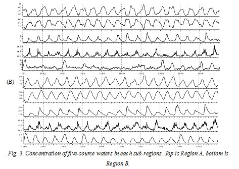
Concentration of five-source waters in each coastal area X axis means the year and Y axis means the concentration (%) of five-source waters (Kuroshio water, Taiwan Current water, Fresh water in East China Sea, Fresh water and Deep sea water in Japan Sea from top to bottom)
.jpg)
In the west part of Japan Sea, Kuroshio water and Taiwan Current water are main components of its coastal water. In Region A, Kuroshio water appeared in winter to spring and its peak is around March. The inflow Kuroshio water moves north-eastward (Region A to Region B, C, D, and E) with about 2 month time lag respectively. In Region A and B, Kuroshio water and Taiwan Current water are found one after another. From winter to spring, Kuroshio water is dominant while Taiwan Current water is dominant from summer to autumn. Such seasonal regular variations occurred in the western part of Japan Sea, and the total concentration of Kuroshio water and Taiwan Current water reached 90 % of the coastal water. On the other hand, the concentration of deep sea water in Japan Sea is not greater than 10 %, and its impact is quite small.
Region C is located in the middle of Japan Sea and it has a unique characteristic. In this region, different from the western part, the variation of Kuroshio water and Taiwan Current water is faded and it has a trend to change in the same phase. It means that Kuroshio water and Taiwan Current water are mixed in this region and it is recognized as one mixed water, namely East China Sea water. This trend increases and has fully same phase in the downstream area, Region D.
From Region D, the influence of deep sea water increases. In Region D and E, deep sea water is dominant in spring to summer, and its concentration is 40 % and 70 % in each region. Due to the increased influence of deep sea water, influences of Kuroshio water and Taiwan Current water are decreased.
In Japan Sea, the impact of freshwaters from the terrestrial areas to East China Sea and Japan Sea is weak comparing to other source waters. In the most closed region to East China Sea (Region A), the concentration of freshwater from the land to East China Sea is a little higher than 3 %. Regarding to the fresh water from the land to Japan Sea, the concentration is smaller.
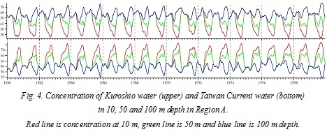
Vertical characteristics of Kuroshio and Taiwan Current waters
Using the vertical average value, timing of inflow of Kuroshio water and Taiwan Current water switch back and forth. However, as shown in Fig. 4, it is clear that Kuroshio water and Taiwan Current water change their inflow depths seasonally. Kuroshio water flows into the surface layer in spring, and flows into the deep layer (100 m depth) in autumn. On the other hand, Taiwan Current water flows into the surface layer in autumn and the deep layer in winter and summer. This pattern continues in Region B, but disappears in Region C due to vertical mixing.
- I. Conclusion
In this study, concentration of the five-source waters in the coastal area of Japan Sea was simulated and showed local characteristics. In the western part of Japan Sea, Kuroshio water and Taiwan Current water are dominant and change with opposite phase. Guo et al. (2006) reported the same variation occurred in Tsushima Strait using numerical simulation, and the surface water of western part of Japan Sea is mainly controlled by these two waters. This report also showed the distribution of two waters at the depth of 10 m above the sea bottom, and mentioned the importance of the Kuroshio onshore intrusion along the shelf break in the East China Sea. Deep water has rich nutrient, therefore such intrusion of deep water from Kuroshio is an important nutrient source to Japan Sea. In Japan Sea, rich nutrient is provided throughout the year. In summer, nutrient rich water which has its origin in shelf water in the East China Sea flows into the sea, and nutrient rich water which its origin in Kuroshio bottom water flows in winter. Such nutrient supply will control primary production in the western part of Japan Sea. More information on the volume of nutrient supply by Kuroshio water and Taiwan Current water is necessary in order to understand the relationship between primary production and nutrient supply from the East China Sea.
In our study, it was showed that Kuroshio water and Taiwan Current water mix at the middle coastal area of Japan Sea. In the east part of Japan Sea, the water which flow into Japan Sea through Tsushima Strait was recognized as the same water mass from the East China Sea. However, it was not clear why these two source waters mix in this region. It is expected to understand the mechanism of mixing by analyzing the relationship with winter vertical mixing and other factors.
Local characteristics simulated by numerical models are useful information for local coastal area management. In order to ensure the mixing of five-source waters, isotope analysis of oxygen-isotope (δ18O) was conducted in parallel. δ18O is one of the indicators of Kuroshio water, and it was measured at the Tsushima Strait. Using the result of isotope analysis, it is expect to show the water mixing and material cycle in Japan Sea. In addition, other project member in the study group investigate the influence of nutrient input from the East China Sea to phytoplankton in Japan Sea. In combination with this study, it is expected to identify the mechanism of variation of primary production in Japan Sea by influence from the East China Sea.
The goal of our study is to develop the management method for sustainable use of coastal area of Japan Sea. We plan to apply the DPSIR (Drive-Pressure-Status-Impact-Response) model. The drivers of environmental change in Japan Sea are climate change and nutrient input. Using numerical models, the pressures of drivers and the status of marine environment in Japan Sea are simulated. Not only restaging the current status but also forecasting of status will be done. Our study group developed two ecosystem numerical models for low trophic level (phytoplankton and zooplankton) and two numerical models on transportation and survival of Japanese Common Squid, Todarodes pacificus, and Snow Crab, Chionoecetes opilio. These two species are major fishery species in Japan Sea. The impacts of marine environmental change primary production and two important species will be forecasted based on the change scenario on climate change and nutrient condition. Response, a management method for sustainable use of Japan Sea will be proposed based on the outputs of our study.
- Acknowledgement
This research was supported by the Environment Research and Technology Development Fund (S-13-3) of the Ministry of the Environment, Japan.
1. Guo X., Y. Miyazawa and T. Yamagata, 2006, The Kuroshio Onshore along the Shelf Break of the East China Sea: The Origin of the Tsushima Warm Current, J. Phys. Oceanogr., 36, 2205-2231
2. Lim S., C. J. Jang, I. S. Oh and J-J Park, 2012, Climatology of the mixed layer depth in the East/Japan Sea, J. Marine Systems, 96-97, 1-14
3. Mindy S., G. Suzie, D. Robert and S. Zachary, Eutrophication and hypoxia in coastal areas: A global assessment of the state of knowledge, 2008, World Resources Institute Policy Note.
4. NOWPAP CEARAC, 2011, Integrated Report on Eutrophication Assessment in Selected Sea Areas in the NOWPAP Region: Evaluation of the NOWPAP Common Procedure.
5. Takikawa, T., J.-H. Yoon and K.-D. Cho, 2005, The Tsushima Warm Current through the Tsushima Straits estimated from ADCP data by ferryboat, J. Phys. Oceanogr., 27, 858-870