


BISAC NAT010000 Ecology
BISAC NAT045050 Ecosystems & Habitats / Coastal Regions & Shorelines
BISAC NAT025000 Ecosystems & Habitats / Oceans & Seas
BISAC NAT045030 Ecosystems & Habitats / Polar Regions
BISAC SCI081000 Earth Sciences / Hydrology
BISAC SCI092000 Global Warming & Climate Change
BISAC SCI020000 Life Sciences / Ecology
BISAC SCI039000 Life Sciences / Marine Biology
BISAC SOC053000 Regional Studies
BISAC TEC060000 Marine & Naval
Below is a brief overview of several quantitative methods for selecting the locations of hydraulic engineering constructions (HEC) to minimize the related environmental costs. These methods were developed and tested by Eco-Express-Service, a company with over twenty years of experience in the industry and extensive expertise in designing HECs. We conduct the following: 1) A multidimensional cluster analysis of the expected human impact; 2) An assessment of the ecological-economic risk in the form of the expected value of the predicted harm to the environment; 3) An express estimation of the expected “environmental cost” of construction activities. Each of these methods is justified, described and illustrated by a specific example. Their use allows to solve such important practical tasks as quantification, classification and the quantitative comparative assessment of the expected impact on the marine environment. This becomes especially important when choosing the optimal location for an HEC and implementing environmental safety measures. An important point is that all of these methods can be recommended for use as Marine Spatial Planning (MSP) “instruments”.
hydraulic engineering works, dredging, land reclamation, aquatic ecosystem, manmade impact.
I. Introduction
The current work presents some applicable examples of quantitative methods for the environmental assessment of hydraulic engineering constructions during design process. In order to find the solution for the task under the present-day conditions it is necessary to create and apply the quantitative analytical methods which consider the regularity of marine environmental reaction to multicomponent human impact.
Here we use the experience of developing and applying such methods by the specialists of the largest ecologic and design company of the North-West of Russia - Eco-Express-Service, a company with over twenty years of experience in the industry and extensive expertise in designing hydraulic engineering constructions (HECs) in offshore areas [1].
The present text describes the possibilities of use of only three such methods: a multidimensional cluster analysis, an assessment of the ecological-economic risks and an express estimation of the expected “environmental cost” of hydraulic construction activities.
II. The use of multidimensional cluster analysis
The HEC optimal location is selected considering a large amount of criteria of different dimensions. At the same time it is necessary to compare the alternative options both with one another and with the so-called “zero option” (in case of no interference and its impact on the further course of succession of the environment). The multidimensional cluster analysis successfully meets the logic of both tasks. Its use can be demonstrated by an example of selecting the deep-water port in Kaliningradskaya oblast judging from the results of multicriterion technical, environmental and economic assessment of the location alternatives (the preliminary off-design stage, 2008-2010).
The creation of the deep-water hub port in Kaliningradskaya oblast is stipulated by the Federal Target Program “Development of Transport System of Russia”. The port is designed as a large transport and logistic hub, to be a most important element of the Russian transport system, providing for the trade-economic interests of Russia in the Baltic region. Feasibility of the large transport and logistic hub creation is conditioned by the tendency of growing cargo traffic in the Baltic region and geographic features of the selected territory for the port construction.
The following options for the location of deep-water port were considered (Fig. 1):
- option 1 – open coast of the Baltic sea;
- option 2 – west coast of the Primorskaya bay;
- option 3 – east coast of the Primorskaya bay;
- option 4 – region of Severny cape on Balga peninsula.
The comparative technical, environmental and economic analysis of alternative options has been implemented on the basis of multicriterion system. Its ecological part included the following quantitative factors of the environmental conditions and the expected impact on the environment:
|
• Straight distance to the nearest residential area |
|
• Status of the land plot |
|
• Straight distance to the nearest specially protected natural reservation (SPNR) |
|
• Total amount of dredging |
|
• Volume of dredging soils suitable for territories creation |
|
• Total amount of land reclamation works |
|
• Square of the detached water area |
|
• Annual sedimentation in access channels and operational waters |
|
• Regularity of necessary repair dredging |
|
• Distance to the nearest inhabitation of specially protected species |
|
• Distance to the nearest regular accumulation of waterfowl and semi-aquatic birds |
|
• Distance to the nearest spawning areas of valuable fish species |
|
• Payments for the environmental negative impact during construction period |
|
• Payments for the environmental negative impact during operation period |
|
• Damage to terrestrial and semi-aquatic biota (including the one in SPNR) |
|
• Damage to water biological resources |
The results of the comparative assessment of four options in Euclidean space of these factors are given in dendrogram in Fig. 2.
Euclidean distances among four options assessed by the sum of the abovementioned factors show that options 2, 3 and 4 are relatively similar in the level of total environmental impact, while option 1 is critically different (significant Euclidean distance from group of options 2-4).
The dendrogram reveals that judging from the level of the expected environmental impact options 3 and 4 are the most similar, and option 1 is the most different from others.
.jpg)
Fig. 1. Diagram of four alternative options of the deep-water hub port location
in Kaniningradskaya oblast
We can view the nearest Euclidean distance between borders of parts in multidimensional criteria space as the generalized measure of environmental impact in every port location’s option corresponding to the absence of the predicted impact (“zero option”) and implementation of this option of location.
When comparing all four options with the “zero” one (i.e. non-interference into the control succession), all conservational quantitative criteria combined, the environmental impact of option 1 is seen as the least intense, option 2 – the most intense, while options 3 and 4 occupy the medium position between them.
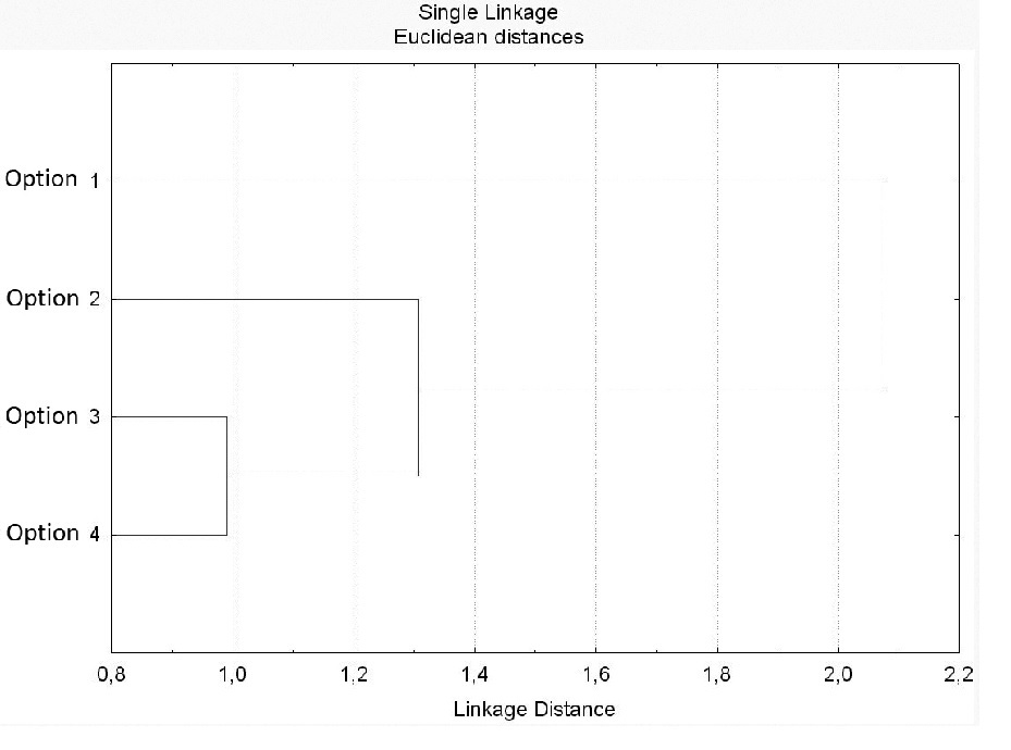
Fig. 2. Results of cluster analysis of the combined characteristics of environmental impact by the deep-water port with four options of its location considered
III. The quantitative analysis of ecological-economic risk
When assessing the expected consequences of the planned hydraulic engineering activities it is usual to consider one simplified scenario of ecologically hazardous events. The assessment includes a nominal solely possible degree of man-caused harm, as if determined by the impact. But in fact it is obvious that the development of ecologically hazardous events cannot be strictly determined in this case and is of probabilistic nature. So in order to predict and minimize the ecological consequences of both developing marine transport system the whole and its parts it is necessary to actively develop and introduce methodology and methods of quantitative analysis of ecological risk. It will provide the approach to regulating ecological risks of port construction on a grounded basis, and preventing excessive impact on aquatic ecosystems on the stage of pre-design and design solutions. At the same time, when choosing the risk measure it is important to consider that only the ecological damage – the cost equivalent of induced changes – can serve as a consistent quantitative characteristic of diverse negative consequences of impact on different environmental components. Accordingly, the assessment of human impact on the environment shall be of the probabilistically cost nature and consider both possibility of realization of negative consequences and their severity level.
As for ecological risks’ assessment the quantitative probabilistically cost approach is viewed as the most relevant one, having become commonly used for the technological risk evaluation [2, 3 etc.]. At the same time the value of ecological risk (R) conditioned by an ecologically hazardous event is interpreted as the mathematical expectation of ecological damage (U):
R=p (1)
p – probability of event realization resulting in damage U.
If it is possible to allocate and quantitatively assess different scenarios of ecologically hazardous events, the tree of events is drawn up. The probabilities and full values of harm to the impact’s recipients in their monetary terms (U) shall be considered for each of the possible alternative events (or scenarios – a sequence of events). The probability of each ith independent scenario realization of ecologically hazardous events from n of potentially possible scenarios (pi) is defined in a multiplicative way:
 (2)
(2)
pij – probability of ith scenario realization in every alternative situation of further events development providing k options.
Expected damage R in monetary terms is defined as a sum of mathematical expectations of damage from realization of alternative scenarios of ecologically hazardous events as per formula:
 (3)
(3)
n – number of analyzed alternative scenarios of ecologically hazardous events caused by an impact of the object; Ri – probable ecological damage from realization of ith scenario in its monetary terms; Ui – full value of ecological damage in physical terms.
As an example of using such approach in design of port complexes we can consider the Preliminary Environmental Impact Assessment (PEIA) of Avantports of the Grand Port of Saint Petersburg implemented by LLC Eco-Express-Service in 2008 [4]. According to the design specification two alternatives of future Avantports’ location were considered. In both cases the system of Avantports would have occupied a significant space – its objects embrace the southern part of Saint Petersburg Flood Prevention Facility Complex (FPFC), the coastline to the east, and according to one of the options – to the west of FPFC, the southern part of Kotlin Island.
The expected environmental impact by the avantports system in both compared alternatives of ports’ location has been thoroughly comparatively assessed with the elements of risk-analysis. The major components of total value of ecological damage from hydraulic engineering activities are known to be conditioned by pollution and sediment spreading in water and co-occurring decrease of water biological resources. The theoretical basis for the calculative studies of expected dynamic of increased cloudiness is presented by synthesized system of two mathematical models: the adapted tree-dimensional thermohydrodynamical model and the model of spread and sedimentation of suspended particles of Princeton University, USA [5].
Usually the expected damage to parts of the aquatic environment caused by sediment spreading and water pollution is assessed by the results of only one model. At the same time many modeling conditions for calculation are selected on a rather subjective basis; this fact significantly devaluates the result. But development of present PEIA included modeling of water muddiness for different variants of possible hydro-meteorological conditions for the period of implementation of works, taking into account the probabilistic realization of each. Consequently judging from the data analysis results of alternative scenarios of ecologically hazardous events’ development, the resultant assessment of damage to parts of aquatic environment was implemented as per formula (3). Eventually the value of ecological risk from muddiness and chemical pollution of water constituted 505 million rubles as per the first option of port location and 501 million rubles as per the second one. The value of ecological risk for fish resources constituted 523 and 497 million rubles accordingly.
The results of thorough comparative assessment of ecological hazard of port location’s alternative options allowed giving grounds to recommend the second option – with partial carry-over of port objects to the west of FPFC. It allowed preserving the group of regional nature reserves being designed (now acting) between “Bronka” port and the city of Lomonosov and at the same time remaining within the limits of acceptable impact on the existing SPNR – nature reserve "Lebyazhye".
Thus the suggested approach to assessment and regulation of ecological risk associated with the development of marine territory shows vivid benefits compared to the traditional “one-scenario” assessment. Calculation of supposedly sole value of future damage determined by an impact is substituted by an analysis of a tree of possible ecologically hazardous events taking into account the probability and cost of consequences of each scenario. This method is more reasonable, realistic and allowing making quantitatively grounded design and management solutions.
IV. The express estimation of the expected “environmental cost” of design
It is obvious that the scope of future human environmental impact of the planned hydraulic engineering activities is largely predetermined during pre-design stage while selecting the variant of alternative design solutions. The analysis of numerous design and monitoring works by Eco-Express-Service Company associated with marine HECs erection allowed us developing and offering quite a simple method of indicative predictive estimation of ecological hazard of the planned hydraulic engineering activities during the pre-design stage. Within the present work it is easier to demonstrate the method on the basis of the sum of hydraulic engineering objects in the Gulf of Finland of the Baltic Sea.
The method is based on revealed regularities of the following indices’ correlation.
1. Impact level indices:
V (million m3) – volume of soil removed during dredging.
S (km2) – square of the created territory.
2. Absolute indices of final environmental changes:
UV (thousand of rubles or thousand of €) – the total amount of payment for the impact on all environmental components (according to the applicable law) during dredging (hereinafter referred to as "environmental cost" of dredging).
US (thousand of rubles or thousand of €) – the total amount of payment for the impact on all environmental components (according to the applicable law) during territory creation (land reclamation) (hereinafter referred to as "environmental cost" of territory creation).
As water biological resources are the main and most vulnerable recipient of human impact as well as the most important component of ecological damage during hydraulic engineering activities, the following indices are estimated separately:
UfV and UfS (thousand of rubles or thousand of €) – value of compensatory payment for the damage of water biological resources during dredging and land reclamation accordingly.
3. Relative indices of environmental changes
- Uv/V (rub/m3, €/m3) – "environmental cost" of a removed soil volume unit (hereinafter referred to as "relative environmental cost" of dredging);
- US/S (thousand rubles/km2 or rub/m2, thousand €/km2 or €/m2) – "environmental cost" of a created territory square unit (hereinafter "relative environmental cost" of territory creation).
- Ufv/V (rub/m3, €/m3) – damage to water biological resources caused by dredging per removed soil volume unit.
- UfS/S (thousand rubles/km2 or rub/m2, thousand €/km2 or €/m2) – damage to water biological resources caused by territory creation per its square unit.
4. Dependencies of absolute values of environmental change from impact level values
For the summary of objects considered one reveals the direct dependency of absolute indices of environmental change in monetary terms (UV and US) from the volume of removed soil (V) and total square of created territory (S). Correlation of these indices is described by the following formulae (UV and US – thousand €, V – million m3, S – km2):
lg Uv = (2.928 ± 0.135) + (0.715 ± 0.115) × lg V; r = 0.77 (4)
lg Us = (2.764 ± 0.158) + (1.063 ± 0.163) × lg S; r = 0.89 (5)
At the same time the value of compensatory payment for the water biological resources damage from dredging works UfV (thousand €) also demonstrated the significant dependency from the removed soil volume V (million m3), which is acceptably approximated by the following formula:
lg Ufv = (2.465 ± 0.115) + (0.651 ± 0.098) × lg V; r = 0.79 (6)
Dependency of the compensatory payment value for the water biological resources damage from new territories creation works UfS (thousand €) from their square S (km2) is described by the formula:
lg Ufs = (2.073 ± 0.164) + (0.861 ± 0.165) × lg S; r = 0.84 (7)
5. "Environmental cost" of dredging and territories creation works in different scopes
When expressing indices of "relative environmental cost” in euro (Uv/V, €/m3 и US/S, thousand €/km2) their correlations with removed soil volume units V (million m3) and land reclamation square S (km2) are formalized as follows:
lg (Uv / V) = (–0.072 ± 0.135) – (0.285 ± 0.115) × lg V; r = –0.42 (8)
lg (Us / S) = (2.459 ± 0.192) + (0.001 ± 0.001) × lg S; r = 0.11 (9)
Changes of indices of the water biological resources damage from dredging works per removed soil volume unit Uv/V (€/m3) in the studied range of removed soil volume V (million m3) are described by formula:
lg (Ufv / V) = (–0.535 ± 0.115) – (0.348 ± 0.098) × lg V; r = –0.56 (10)
Changes of indices of the water biological resources damage from territory creation per square unit Us/S (thousand €/km2) in the studied range of land reclamation square S (km2) are described by formula:
lg (Ufs / S) = (2.073 ± 0.164) – (0.139 ± 0.165) × lg S; r = –0.25 (11)
Thus it is obvious that dependency of used absolute indices of the final environmental changes (UV, US, UfV and UfS) from absolute indices of impact level (removed soil volume V, created territory square S) is reliable, positive and quite well formalized. Relative indices of environmental changes (UV/V, US/S, UfV/V and UfS/S) are randomly varied within the studied ranges of impact indices, their dependencies from the scope of hydraulic engineering works are not revealed. It allows defining (by its meaning) and using averaged values of the indices in approximate prognoses.
It is revealed that distributions of values of all four abovementioned relative indices are characterized by the prominent positive asymmetry and acceptably approximated by the lognormal distribution [6]. Therefore it is the most correct way to express the mathematical expectations of these indices as logarithmic mean values:
 (12)
(12)
Subsequently if one multiplies these indices by the value of planned total soil volume removed during dredging or by the total square of created new territories, during pre-design stage it is possible to get the preliminary approximate prognosis of the value of ecological-economic damage associated with the hydraulic engineering works to be planned.
Obviously the variability of real relative indices of environmental changes around these mean values is defined by a number of synergically correlating factors. For that reason each design can have the specified values of the indices (defined by the results of full cycle of environmental design documentation development) that differ from abovementioned mathematical expectations. Accordingly if the hydraulic engineering design is characterized by positive values of the abovementioned factors, its “relative environmental cost” will be lower than the expected average value, and vice versa. The results of the conducted analysis allowed offering the following classification of the expected environmental impact of the hydraulic engineering activities:
1) Low impact: Uv/V< 0,1 €/m3; Us/S < 0,1 €/m2
2) Mild impact: 0,1≤ Uv/V< 1,0 €/m3; 0,1 ≤ Us/S < 1,0 €/m2
3) Significant impact: 1 ≤ Uv/V< 10 €/m3; 1 ≤ Us/S < 10 €/m2
4) Intensive impact: Uv/V ≥10 €/m3; Us/S ≥ 10 €/m2
The given regularities allow approximate predicting the mathematical expectation of ecological-economic damage by hydraulic engineering activities during pre-design stage as per its major characteristics – total volume of soils to be removed during dredging and the summary square of the newly created territories.
V. Conclusion
Development and approbation of the quantitative analytical methods system allows solving tasks of both environmental assessment of the hydraulic engineering constructions under design process and optimal distribution of different types of marine uses in space and time. The presented examples show some scope of a considerably natural quantification, classification and quantitative comparative assessment of planned impact on the marine environment.
The described methods developed or adapted for solving the design tasks can be effectively used with minimum changes for solving similar tasks of Marine Spatial Planning as well, becoming a part of its quantitative instruments.
Please find related publications on the Eco-Express-Service website: http://ecoexp.ru/page/34.
1. V.A. Zhigulsky, V.F. Shuisky, Y.A. Shchashchaev, and T.S. Bylina, “LLC "Eco-Express-Service": the experience of evaluation and prediction of impact on aquatic ecosystems as a result of hydraulic construction,” Pybookhrana Rossii, N 2 (6), pp. 42-47, 2011.
2. Safety manual “Approval of safety guidelines method for accident risk assessment for hazardous petroleum refining and petrochemical industry facilities,” (Rostekhnadzor Order N 646 of December 27, 2013).
3. Safety manual “Method for accident risk analysis for hazardous industrial facilities of marine oil and gas complex,” (Rostekhnadzor Order N 364 of September 16, 2015).
4. Development program of the Avantports of the Saint Petersburg Grand Port. The preliminary assessment of environmental impact considering existing and future specially protected natural reservations. Volume 4, LLC “Eco-Express-Service”, 1998.
5. V.A. Zhigulsky and V.N. Konoplev, “Integrated technology for model studies in offshore,” Proceedings of international conference “Oil and gas of Arctic shelf”, Murmansk, November 12-14, 2008 - Murmansk: MMBI KNTS RAS, 2008. - Pp. 141-158.
6. V.A. Zhigulsky, V.F. Shuisky, and N.A. Solovey, “Method of predictive express estimation of environmental hazard of hydraulic engineering works,” Gidrotehnika, N 1(26), pp. 68-71, 2012.