


BISAC NAT010000 Ecology
BISAC NAT045050 Ecosystems & Habitats / Coastal Regions & Shorelines
BISAC NAT025000 Ecosystems & Habitats / Oceans & Seas
BISAC NAT045030 Ecosystems & Habitats / Polar Regions
BISAC SCI081000 Earth Sciences / Hydrology
BISAC SCI092000 Global Warming & Climate Change
BISAC SCI020000 Life Sciences / Ecology
BISAC SCI039000 Life Sciences / Marine Biology
BISAC SOC053000 Regional Studies
BISAC TEC060000 Marine & Naval
The interests of forecasting of the area’s development simulate to take more attention to the study of its newest tectonics. The most informative tectonic pattern for the studies of coastal zones is neotectonic one, based on the structural principle, which shows the newly formed and inherited dislocations, reflected in the modern landscape and exodynamics of the earth's surface. The question of the manifestations of newest tectonics by way on the example of the Vistula Spit (Baltic Sea) is discussed.
newest tectonics, coastal zone, sea level, Baltic Sea, Vistula Spit
I. Introduction
Newest tectonics stress initial and create new irregularities of the earth's surface, thereby controlling the specificity of exogenous morpho- and lithodynamic processes. As a consequence, it influences on the features of development of denudation and accumulative relief, of sediment’s transit, of formation of lithologic varieties, of capacity and mechanical properties of the deposits and others. One of the main aspects of the newest tectonics exhibits in the creation of the initial inclination of the earth's surface. The latter, in particular, predetermine the development of the coastal zone according to accumulative or abrasion scenario. The lithological features, as well as the climate, affect mostly on the rate of coastal processes, without being able to radically change their orientation. We can consider the values in the range of 0.001–0.005 as the optimum inclinations of the underwater coastal slope defining relatively calm state of the coastal environment. It should be emphasized that in a coastal zone’ conditions a natural situation may appear when the bottom inclination changes only enough 0.001 (tg), so that the accumulative scenario of its development changes for the abrasion or vice versa. And such change can happen tomorrow, because as long as the powerful thermal pot in the entrails of the Earth functions, long geological tectonic quiescence state on its surface will never be. It is believed that the minimum period of restructuring of the underlying processes, initiating the structure-forming movements, is 10 thousand years [1]. Therefore the beginning of the ongoing young tectonic phase can be attributed to the boundary of the Late Pleistocene-Holocene.
Many researchers of the coastal zones often do not attach importance to newest tectonics, because they believe that tectonic movements now are too slow. Indeed, if one projects the amplitudes of vertical movements on the entire period of neotectonic development of the region, we obtain the velocities close to 0.01 or even less. But! Tectonic movements do not occur uniformly, but as impulses for a geologically short time, they alternate with periods of acceleration, a longer deceleration and even of local short rest. An important feature of the newest tectonic movements, including today, is the fact that, they are characterized by the inheritance of the sign and often of the speed in their temporal manifestation [2]. At the same time the tectonic processes inheritance determines the coastal processes one that are well reflected in the coast’s types [3]. The rate of vertical tectonic displacement already considered significant when the value is 1 mm per year and is particularly crucial in the formation of coast’s subtypes, the position, size and configuration of coastal accumulative forms, as evidenced by the example of seashores [4]. Some area of the coastal zone is undergoing significant changes even when the area’s coastline comes out of the influence of a structural-tectonic element particular expressed at the surface. It also occurs when it passes to another part of the same element, for example, during the transfer from the seaside declining wing of anticline to the opposite wing. Therefore, the most informative tectonic pattern for the studies of coastal zones is neotectonic one, based on the structural principle, which shows the newly formed and inherited dislocations, reflected in the modern landscape and exodynamics of the earth's surface. Such patterns allow representing the picture of tectonic organization of geological space (blocks, folds, faults, etc.), focusing and, where possible, the activity of the movement of the selected elements in the tectonic structure more legibly. Criteria for selection of the newest structural and tectonic elements and the evaluation of their dynamics are widely covered in Russian literature and in some foreign publications. In light of above-mentioned it is obvious that the interests of forecasting of the area’s development simulate to take more attention to the study of its newest tectonics.
As to the sea shores one can judge the neotectonic manifestations with high confidence on the basis of structural and geomorphological method with study of features in the distribution of various forms and elements of the earth's surface relief, of its morphographic and morphometric properties in the border area land – sea, of the specifics of the spread, occurrence and composition of the adjacent deposits, of the nature of coastal abrasion–accumulation, erosion and denudation, and others processes. The differentiation of the territory according to these criteria regardless of the commitment of the researcher to any geodynamic concepts is the basis for the mapping of neotectonic patterns, including the structural principle, usually with highlighting of raises, depressions and so-called "weak zones" predefined by the disjunctive tectonics.
II. Geomorphological characteristics of the Vistula Spit area
Vistula Spit is located in the south-eastern sector of the Baltic Sea (Fig. 1). In accordance with the indicated methodological approach the southeastern area of the Baltic Sea has the following largest orographic formations (Fig. 2): Sambian elevation, Pregel lowland, Warmia elevation, Paslenk depression, Elblag elevation.
 2 фигура 1.jpg)
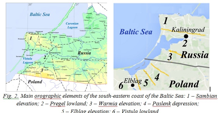
Warmia elevation is in fact the northern slope of Turow hills in Poland. Elblag elevation is relieved by the Vistula lowland to the south, which stretches far inland to the Bydgoszcz city’ suburbs.
Within the Vistula Spit one can identify a number of areas on hypsometry scale 1:50 000 in the direction from north to south. 1 – from the Baltic channel to the Chayachy (Taran) Cape. It is characterized by the development of individual low (rarely more than 10 m) and small dunes and a well-defined low near-bay terrace formed on the delta plain and forming the broader land prominences towards the Vistula Lagoon. 2 – from the Chayachy Cape to the Cape Razmytyy. Here the narrowing of the spit occurs and levelled aeolian-marine surface palve between the seaward foredune ridge and the ancient high dunes in near-bay area appears (Fig. 3). 3 – from Cape Razmytyy until Cape Vysokiy inclusive. Here the spit expansion approximately twice comes and the signs of a double ridge of dunes occur. Single morphosculptural form with up to 25 m height near Cape Glavnyy is perhaps the rib of delta plain or moraine, as well as a similar, previously noted [5], the rib near the Cape Vysokiy (+24 m). These relief elevations are separated by low-elevation site with some small (up to 5 m) dunes. 4 – southward to the Cape Vysokiy up to the area of Pyaski (Fig. 4) village the spit again approximately doubled narrows and in almost edgewise the rapid development of dunes up to 30–36 m height is shown. 5 – southward to the Pyaski village up to 54˚32' N the spit’s width is slightly increased, accompanied by an extension of the adjacent shallow areas of the bay, and south to latitude 54˚23' the spit again narrows to the size of area 4. Here the double ridge of dunes is clearly traced. The higher (up to 20–27 m) one is shifted to the bay. The ridge with height of 5–15 m is located seaward. 6 – from the southern border of the previous section to the village Borovoye inclusive, this area as compared to the southern part of the previous section, expands about twice and is characterized by a more expressive manifestation of double ridges at similar marks of elevations, sometimes exceeding 40 meters. This area is characterized by the development of the highest dunes of the spit. 7 – southward to the village Borovoye the spit’s width is reduced by almost half and high (up to 34 m) dunes along its width occur. This morphosculptural situation continues in the root part of the spit, where from approximately longitude of inner part of the Vistula Lagoon the double expansion of this accumulative form and the division of the dune complex into two ridges such as higher (up to 37 m) coastal and lower (12–15 m) rear separated by a low relief area take place. Thus, the spit largely consists of aeolian sands forming several generations of forms. In its structure there are the ribs of water-glacial plain, preserved from erosion by as sea waves, and the waves of the lagoon [5–7] (Fig. 3, 5).
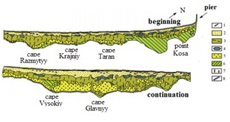
Fig. 3. Geomorphological map of the Vistula Spit [6, with some refinements]: 1 – foredune ridge; 2 – seaside dune swell; 3 – levelled regressive aeolian-marine surface – “palve”; 4 –swampy depressions of the old lagoons; 5 – elevated old dune massifs; 6 –old deltas plaines with low near-bay regressive terrace; 7 – deflation basins in dunes; 8 – ledges of the scouring
.jpg)
It should be found the cause of the considered fragmentation of the spit along its strike with its distinct contraction and expansion (in four respectively), as well as bathymetric differentiation of the bay in the history of their origin and development, in the degree of participation of related factors and agents. Late Quaternary deposits are represented here by South Lithuanian moraine complex simulated by fluvial processes. The latter created a low-lying alluvial plain with separate jets of moraine hills, many of which are associated with positive neotectonic structural forms. Under the conditions of the coastal lowland the riverbeds divided into shallow branches. The original nucleuses of concerned accumulative forms were laid during the Holocene transgression as submarine swells, gradually shifting towards the land because of the specificity of coastal hydrodynamics. Under certain conditions the largest ones have been converted into bars. It may be assumed, the latter located primarily in estuarine areas of river valleys with their loose sediments’ supply. It is also possible that the bars were formed on the underwater continuation of low watersheds leveled by marine abrasion, when the alluvial moraine material allowed forming a profile of equilibrium quickly, and it is shifted towards the land parallel to itself as far as the advance of marine transgression. In time, in the coastal area along with the transverse movement of sediments their longitudinal movement was formed. The latter has led to damming of branches of subaerial valleys and to joining of the bars into a single spit, which was developed by its own laws, including the active manifestation of aeolian processes. Only the section in the northern part of the bay bar on the continuation of the most developed branch of the Pregel River was the least resistant to sea wind and wave action, and from time to time here the passage into the isolated by spit Vistula Lagoon was formed, so it was turning into the bay.
As a single form the spit was formed in historical times. Even in the XII century there were a few island bars. Since the first half of XVI century the appeared passage was artificially maintained as the Baltic Canal. Southward located fragment of the bay bar became known as the Vistula (Baltic) spit. Sometimes one calls the part of the spit to the south of the Poland-Russia boundary the Vistula, and the northern part – the Baltic spit.
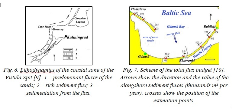
In consideration of the fact that the period of the spit’s existence as the bay bar was inevitably accompanied by an opposite longshore flux from the north and south sides, it was to be expected that the broadest part of this form should be in the middle part of spit, in the area of the convergence of the longshore fluxes. It has been observed at present [9, 10] (Fig. 6, 7). However, it is difficult to explain the location of the spit, the morphological heterogeneity of the spit and the adjacent bay as an effect of the exogenous factors only. It seems that on condition of a practically single geological structure of the substrate of the spit and the bay the prominent role in their formation and in their modern form belongs to differentiated vertical newest tectonic movements of this substrate. It is logical to assume that the latter were intensified due to alternation of glacial loading / unloading. Such activation has occurred the most impressively in the zones of tectonic faults, accompanied by shifts of tectonic blocks on them.
IV. Geostructural position and newest tectonics of the area of the Vistula Spit
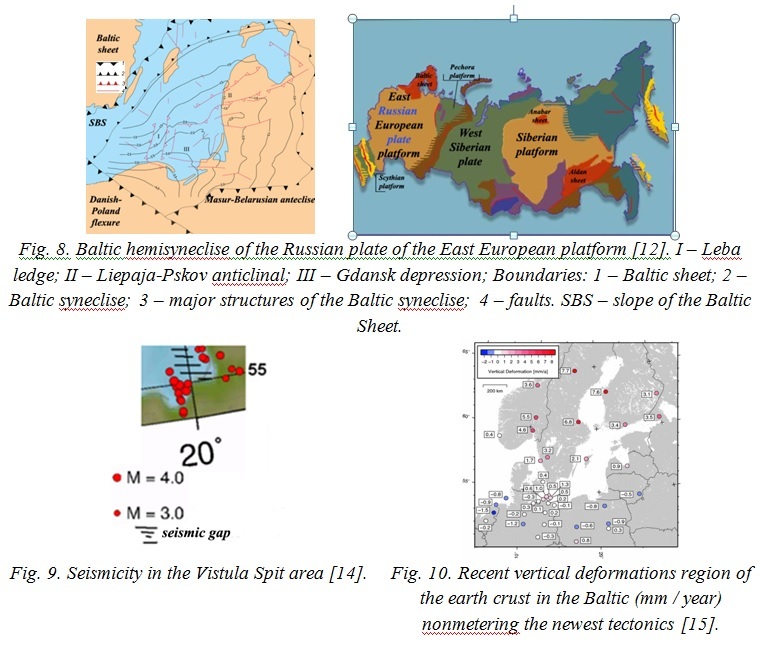
In geostructural respect the spit is located in the south-east wing of the Gdansk depression [11], complicating the Baltic (the Baltic, the Baltic-Belarusian) gemisyneklise of the Russian plate of the East European platform [12] (Fig. 1, 8). The newest stage of tectonic development of the region began in the late Oligocene, accompanied by subaerial environment and by deformation of the original levelling surface, which is consist of the Rupel layers of early Oligocene. This period is followed by the phases of structural formation and restructuring. Since 6 thousand years BP due to the termination of glacial isostasy [13] the region is subject only to the newest tectonic movements and the seismicity, the energy of which is estimated at 4 magnitude [14] (Fig. 9). Modern geodynamics of the spit according to some researchers is characterized by a weak relative fall movement [14] (Fig. 10).
The modelling of cartographic patterns of the newest tectonics of the study area is provided on the basis of its structural and geomorphological analysis accounting the methodological procedures [16, 17]. The most important criteria are the orographic and genetic features of subaerial and subaqueous relief, strike and types of seashores, shape and cross-section isohypses and isobathics, orientation and shape of the river valleys, usually originating in the positive structural forms and developing in negative neotectonic structural forms or in tectonically predetermined lineaments as weakened zones of near-surface horizons of the crust, locking the tectonic faults. As a result of the research the cartographic pattern of newest tectonics of the study area is made (Fig. 11).
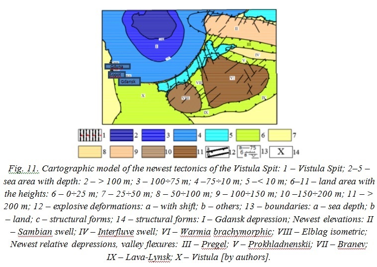
It shows the dominant development of the plicative newest structural forms in the forms of elevations and depressions in different scale. Disjunctive dislocations generally have a modest value, but are important at the local level. The latter is related directly to the Vistula Spit.
According to the degree of uplift activity determined by their elevations, and the structure and the depths of cuttings of river valleys, they can be ranked in descending order: VI, VIII, II, IV (Fig. 11). The latter apparently is the youngest. As for the faults one can says that their length corresponds to the upper crust origin. Most likely, they are not as newly formed, as present an updated version of the older one, activated by Quaternary glaciers and earthquakes in the adjacent areas. As for the spatial distribution of these disturbances there is the considerable prevalence of north-western strikes in the south of the region, which replaced to the north-eastern strike from Pregel lowland to Sambian swell. This, perhaps, is a sign of the local differentiation of global compressive stresses directed from the Mid-Atlantic Ridge.
According to the presented pattern of newest tectonics, the identified faults with northwest strike complicate the eastern slope of the Gdansk depression, making its weakly differentiated block structure. Within the limits of this structure the formation of the Vistula Spit occurred. The location of the faults in the spit area is in good agreement with those of an earlier study [14], with the only difference that the authors suggest their sublatitudinal strike.
The comparison of geomorphological data from the Vistula Spit with the neotectonic pattern shows that the widest parts of it and the development of high dunes correspond to the raised blocks. Perhaps, these areas were more favorable for the initial slopes, predetermined the earlier formation of nuclear fragments of spit (original bay bar) and subsequent accumulation of coastal sediments supplied from underwater slope.
In general, the newest geodynamics of the area is characterized by differentiated raising, in which the slope of the Gdansk depression where the Vistula Spit was formed is involved. Among the signs of uplifting the abrupt banks of even small rivers of the sea coast, reducing of the width of valley flexures due to the growth of adjacent elevations, manifestations of faults in the Quaternary sediments, the presence of the Late Holocene overflow coastal terraces and others can be noted. It can be assumed that now the rate of uplift of spit area is approximately comparable (at least, no less) with the uplifting rate of the Baltic Sea level caused by the current, geologically short-lived climatic cycle of the planet. This circumstance can explain the relatively stable state of the spit seashore, since the depth of the underwater coastal slope also remained practically invariable, allowing the wind-wave factor to mobilize available bottom sediments and to carry them to the shore. If the rate of uplift exceeded the transgression one, the sea waves would lose some of the energy away from the shore, and it could lead to the formation of new submarine swell, which do not necessarily have shifted to the modern coastline. When lifting rate is less than the rate of transgression the depth of the underwater slope would increase and sea waves would approach the shore with higher energy, causing its erosion. On near-channel spit area because of the intervention of human factor the coastal hydrodynamics, which determines the erosion of the spit due to the local conditions, plays a major role. The lowering rate of the area in limits 0 ÷ –1 mm / year (Fig. 10) is obtained only by extrapolation, it is relative, and fixes the total transgressive effect of the current climate cycle and neotectonic state of the specific location of its observation.
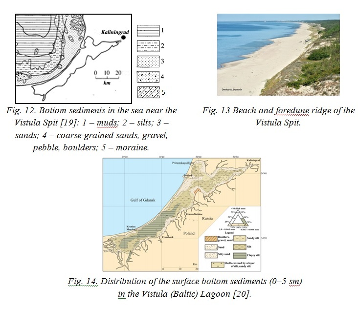
At the present time the climate is in the cooling phase, which will last about 15 years [18]. As you know, cold weather does not lead to an increase of sea level. So, it follows that eustatic factor will not appreciable influence on the evolution of the Vistula Spit at least in engineering (50–60 years) time scale. The budget and the balance of beach-forming deposits will have main importance in the dynamics of the coastal zone of the spit (Fig. 5, 12, 13, 14). It is not expected the catastrophic changes in the development of the spit on natural scenario for this time, because the coastal morphogenesis adapted to the current situation. In the long term we can expect the disappearance of the Vistula Lagoon because of its filling by sediments and weak tectonic uplift of the area.
|
|
V. Acknowledgment
This work was financially supported by the RSF (grant № 14-17-00547, parts: geostructural position and newest tectonics) and by the State programme (theme 0149-2014-0035, parts: geomorphology and lithology).
1. A.F. Grachev, I.V. Kalashnikova, and V.A. Magnitskii “Modern movement of the earth crust and the seismicity”, Izvestiya. Physics of the Solid Earth, vol.11, pp. 3-11, 1990 (in Russian).
2. I.V. Kalashnikova and V.A. Magnitskii “On the inherited type of modern movements of the earth crust” Izvestiya. Physics of the Solid Earth, vol.10, pp. 13-20, 1978 (in Russian).
3. V.P. Zenkovich, Main areas of the investigations of the sea coastal zone in the USSR. Theoretical issues of the sea coast dynamics. Moscow, Nauka, pp. 3-13, 1964 (in Russian).
4. L.G. Nikiforov, Structural geomorphology of the sea coasts. Moscow: MSU Publ., 175 pp., 1977 (in Russian).
5. E.N. Badyukova, L.A. Zhindarev, S.A. Luk’yanova and G.D. Solov’eva “Geomorphology and the history of development of the Curonian and the Vistula spits (SE Baltic)” in Strategiczne pytania swiatowej nauik, vol. 29. Ecologia, Geografia I geologia. Przemysl (Poland): Nauka i studia, pp. 72-81, 2014 (in Russian).
6. E.N. Badyukova, L.A. Zhindarev, S.A. Luk’yanova and G.D. Solov’eva “The geologic-geomorphological structure of the Baltic (Vistula) Spit”, Oceanology, vol. 51 (4), pp. 675-682, 2011.
7. E.N. Badyukova, L.A. Zhindarev, S.A. Luk’yanova and G.D. Solov’eva “The peculiarities of the geologic-geomorphological structure of the Baltic (Vistula) Spit”, Theory of the sea coast development: age-old traditions and ideas of the modernity, pp. 170-172, 2010 [Abstracts Conf., 2010] (in Russian).
8. A. Tomczak, J.E. Mojski, J. Krzymińska, et al. “New data on geologic structure of the Vistula Bay Bar”, Kwartalnik Geologiczny, vol. 33 (2), pp. 277-300, 1989.
9. V.L. Boldyrev and O.I. Ryabkova “Dynamics of the coastal processes on the Kaliningrad coast of the Baltic Sea”, Izvestiya of Russian Geographical Society, vol. 133 (5), pp. 41-49, 2001 (in Russian).
10. I. Leont’yev and T. Akivis “Evolution forecast of the gulf of Gdansk sand spits in 21 century”, Sea coasts - evolution, ecology, economy, vol. 1, pp. 239-243, October 2012 [Materials XXIV Inter. Coastal Conf., 2012] (in Russian).
11. A.G. Grigoriev, V.A. Zhamojda, M.A. Spiridonov, A.Yu. Sharapova and V.V. Sivkov “New data on the history of the development of the south-eastern part of the Baltic Sea from the Late Ice Age to the present”, Regional geology and metalogeny, vol. 40, pp. 103-114, 2009 (in Russian).
12. Geographical atlas of the Kaliningrad region, V.V. Orlenok, Ed. Kaliningrad: KSU Publ., 276 pp., 2002 (in Russian).
13. A.F. Grachev and P.M. Dolukhanov, “Subglacial raising of the earth crust in Canada and Fennoscandia according to the data of radiocarbon dating”, Baltica, vol. 4, pp. 297-312, 1970 (in Russian).
14. Seismotectonics of the old platform plates in the area of the Quaternary glaciation. Part 1. Kaliningrad region and the adjacent area, R.G. Garetskii and S.A. Nesmeyanov, Eds. Moscow: Book and business, 228 pp., 2009 (in Russian).
15. M. Lidberg, J.M. Johansson, H.G. Scherneck and•J.L. Davis, “An improved and extended GPS-derived 3D velocity field of the glacial isostatic adjustment (GIA) in Fennoscandia”, Journal of Geodesy, vol. 81, pp. 213-230, 2007.
16. N.I. Nikolaev, “On the principles of the drawing up of the newest tectonics maps during the neotectonical zoning”, Izvestiya VUZov, Geology and prospecting, vol. 4, pp. 3-12, 1982 (in Russian).
17. Application of the geomorphological methods in the structural-geomorphological investigations, Moscow, Nauka, 296 p., 1970 (in Russian).
18. R.I. Nigamtulin, N.V. Vakulenko and D.M. Sonechkin, “Global warming in reality and in the climatic patterns”, Turbulence, atmosphere dynamics and climate, pp. 76-79, May 2013 [Abstracts Inter. Conf., 2013] (in Russian).
19. N.I. Sviridov and E.M. Emelyanov, “Facial-lithological complexes of the Quaternary deposits of the Central and south-eastern parts of the Baltic”, Lithology and Mineral Resources, vol. 3, pp. 246-267, 2000 (in Russian).
20. Zachowicz and S. Uscinowicz, Geochemical atlas of the Vistula Lagoon. Warszawa, 1996.