


BISAC NAT010000 Ecology
BISAC NAT045050 Ecosystems & Habitats / Coastal Regions & Shorelines
BISAC NAT025000 Ecosystems & Habitats / Oceans & Seas
BISAC NAT045030 Ecosystems & Habitats / Polar Regions
BISAC SCI081000 Earth Sciences / Hydrology
BISAC SCI092000 Global Warming & Climate Change
BISAC SCI020000 Life Sciences / Ecology
BISAC SCI039000 Life Sciences / Marine Biology
BISAC SOC053000 Regional Studies
BISAC TEC060000 Marine & Naval
The information resources of the Federal State Budget Scientific Institution “Marine Hydrophysical Institute of RAS” (FSBSI MHI) oceanographic data bank (MHI BOD), which contains about 115,000 oceanographic and more than 27,000 hydrochemical stations accomplished in the Black Sea coastal zone, as well as experience accumulated while providing information support of the coastal zone research, main directions of activities, and short-term plans are considered.
Black sea, coastal zone, databases and data banks, oceanographic data, quality control.
- Introduction
The coastal zone of seas and oceans has been exploited by mankind for a long time. The state of the coastal zone environment and processes taking place here have a significant influence on human being and marine economy of seaside countries. Solving problems of the integrated coastal zone management, study and analysis of the processes determining its evolution, and forecast of possible changes need reliable information support. All this predetermines the most important role of oceanographic data and knowledge while conducting ecological and oceanographic research, project exploration in the coastal zone, working out different recommendations for its sustainable use and for making managerial decisions.
A significant experience of creating oceanographic databases and banks, maps, atlases, geoinformation systems, and other products aimed at providing information support of oceanographic research and practice, including those in the coastal zone, was accumulated in the Department of Marine Information Systems and Technologies (MIST) of FSBSI MHI for its more than twenty years’ history, while conducting national and international projects.
At present, these activities, in cooperation with other scientific institutions, are carried out in the following main directions:
- working out and forming specialized databases and banks;
- improving data quality check systems;
- creating maps and atlases for different marine environmental parameters;
- working out and creating information systems;
- designing and creating web-sites.
Let us discuss in detail some of the directions mentioned above.
- Working out and forming databases
MHI BOD includes oceanographic and meteorological data obtained in cruises of research vessels of MHI and other institutions in the Black, Azov, and Mediterranean seas and also in the Atlantic, Indian, and Pacific oceans. “The Black Sea” specialized database has a special position in the BOD and contains data on more than 160,000 oceanographic (since 1890) and 43,000 hydrochemical (since 1923) stations made by research vessels of Russia, Ukraine, Bulgaria, Turkey, USA, France, Romania, Denmark, and other states, as well as data on a number of other parameters [1].
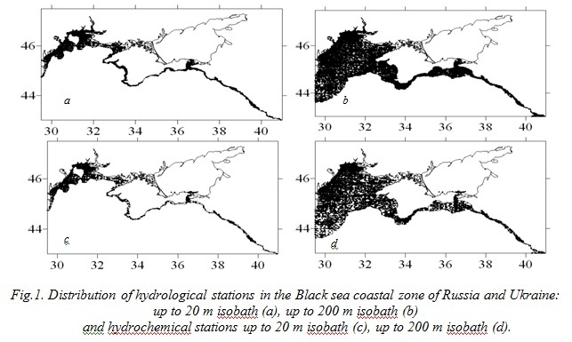
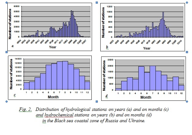
It should be noticed that a considerable part of the Black sea oceanographic and hydrochemical stations was accomplished in the coastal zone (Table 1) and most of them were in the coastal zone of Russia and Ukraine (Table 2, Fig.1 and 2).
Table 1. The number of hydrological and hydrochemical stations in the Black sea
|
Parameters |
Black sea |
Isobath, m |
||||
|
20 |
50 |
100 |
150 |
200 |
||
|
Number of stations |
||||||
|
Hydrology |
160085 |
53253 |
91336 |
108309 |
112886 |
114972 |
|
Hydrochemistry |
43231 |
10219 |
18106 |
25161 |
26417 |
27117 |
Table 2. The number of hydrological and hydrochemical stations in the Black sea coastal zone of Russia and Ukraine
|
Parameters |
Isobath, m |
||||
|
20 |
50 |
100 |
150 |
200 |
|
|
Number of stations |
|||||
|
Hydrology |
48255 |
81079 |
92096 |
95819 |
97419 |
|
Hydrochemistry |
8389 |
13950 |
18187 |
18988 |
19461 |
At present, MHI BOD receives data obtained with the use of such equipment for oceanographic observation as drifters and towed devices of different types. Depending on the type, the devices provide obtaining such data as seawater temperature distribution in depth and on the surface, air temperature and atmospheric pressure, currents, certain hydrochemical parameters, etc. These data are contained in special arrays in MHI BOD. Table 3 gives information on their number for the Black sea coastal zone.
Table 3. Number of measurements accomplished using towed devices and drifters in the Black sea coastal zone
|
Water area |
Device |
Isobath, m |
||||
|
20 |
50 |
100 |
150 |
200 |
||
|
Number of measurements |
||||||
|
Black sea coastal zone |
Thermistor chain drifter |
1015 |
3049 |
13462 |
14466 |
14940 |
|
Drifter |
4085 |
11932 |
35857 |
41015 |
43338 |
|
|
Towed |
3241 |
5094 |
7064 |
7514 |
7664 |
|
|
Coastal zone of Russia and Ukraine |
Thermistor chain drifter |
0 |
523 |
4647 |
5232 |
5453 |
|
Drifter |
931 |
5296 |
15420 |
18906 |
20323 |
|
|
Towed |
3241 |
5094 |
7064 |
7514 |
7664 |
|
MHI BOD also stores data obtained at the oceanographic platform in the village of Katsiveli (meteorological measurements, waves, water temperature, salinity, currents, hydrochemistry, etc.) and at the Golitsyn platform (meteorological measurements, water temperature).
Depending on the problems under solution, the specialized databases for the coastal zone study can contain hydrological data on temperature and salinity, hydrochemical data, including alkalinity, pH, oxygen, silicates, nitrates, nitrites, phosphates, hydrogen sulphide (about 20 parameters in total), data on hydrooptics, waves, currents, sea level, and other parameters. The databases can be created both for the entire coastal zone and for its significant parts or certain water areas. As examples one can take the prepared in MHI BOD specialized databases on the Black sea coastal zone of Russia and Ukraine, the databases intended to study the hydrochemical regime of Yalta bay, environmental state of Sevastopol bay, coastal waters of the Heracles peninsula, etc.
- Data quality check
While creating databases, the MHI BOD specialists pay great attention to data and metadata quality. The work aimed at developing and improving data quality check systems has been conducted at the MIST department for a long time [2]. The results of the activities were acknowledged both at the national and international levels.
Taking into account the coastline proximity, complicated interaction of various factors effecting generation of hydrophysical and hydrochemical fields in the coastal zone, the data quality check becomes of particular importance. To solve the posed question, the following step-by-step procedure is realized in MHI BOD:
- data import and conversion into the necessary format;
- metadata check:
- location check;
- date/time (including velocity and chronology) check;
- sea depth/last sounding value check;
- automated quality flags setting.
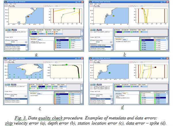


Some examples of metadata and data errors detected as a result of applying the data quality check procedure while forming a specialized database for information support of the coastal zone research are presented in Fig. 3.
- Examples of the database use
The database is in active use while studying natural processes and environmental state of certain water areas in the framework of both national and international projects. Applying this database in realization of the PEEX "Pan-Eurasian Experiment" project can serve as an example [3].
The successful realization of the PEEX "Pan-Eurasian Experiment" Program is impossible without reliable information support both on the global and regional levels.
MHI accumulated a considerable experience in creating data banks and specialized databases and developing on this information basis a wide range of differently targeted information products.
Due to the unique location of the Crimean peninsula, the information on the state of individual environmental components (in particular, the atmosphere), obtained there, is undoubtedly valuable for successful realization of the project tasks.
Creating, in the framework of the PEEX Project, the proper regional specialized databases and software to provide their management and data quality control is of current importance. At the first stage, it seems to be expedient to include into the database the information obtained in a number of observation points located both in the sea-land interactive zone (Golitsyn platform, Sevastopol bay, the oceanographic platform and the set of sensors in the village of Katsiveli, Tuzla spit, and the coastal area of Lubimovka village) and in the central part of the Crimean peninsula (e.g., Simferopol).
It is also planned to include drifter and solar radiation data into the database. The location of observation points and drifter paths in the Black Sea are shown in Fig. 4.


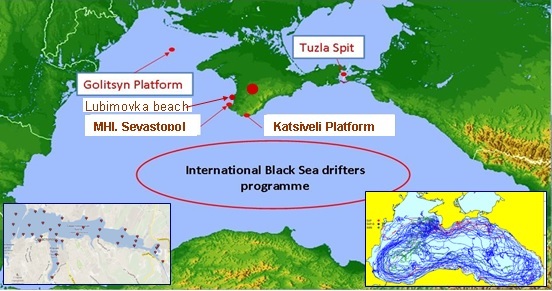
Fig. 4. Location of observation points. The insets show the location of observation points
in Sevastopol bay and drifter paths in the Black Sea.
The database creation will allow more proper solving tasks of modeling in the sea-land interface area, as well as estimating the situation in the area of the Crimean peninsula and obtaining integrated characteristics of the environment.
The list of the parameters to be included into the database is shown in Table 4.
Table 4. The parameters to be included into the database
|
Station |
Coordinates |
Observation Parameters |
Equipment |
Period |
|
Golitsyn Platform |
45°43'23"N 31°50'16"E |
Wind and Wave Parameters |
Hydrometeorological complex KCTD + waverecorder |
1995-2005 |
|
EB MHI NAS Ukraine |
44°23'42"N 33°58'28"E |
Wind and Wave Parameters |
Hydrometeorological complex KCTD + waverecorder |
2003-2014 |
|
Temperature Chain |
Temperature Chain |
|||
|
Sea Level |
MedGLOSS Station |
|||
|
Tuzla Spit |
45°16'13"N 36°32'49"E |
Wind and Wave Parameters |
Hydrometeorological complex KCTD + waverecorder |
2007-2013 |
|
MHI NAS Ukraine |
44°36'56"N 33°31'1"E |
Direct and Scattered Radiation of the Sun |
Solar Spectrophotometer CIMEL380N |
2006-2014 |
|
Drifters |
Black Sea |
Sea Surface Temperature, Temperature Chain |
SVP Drifters with Temperature Chain |
1999-2014 |
|
Lubimovka beach |
|
Beach characteristics (length of beach, length of coastline, perimeter and area, coastline curvature, height and slope of cliff - average slopes of berm and bench and etc.) |
|
2009-2015 |
|
Sevastopol bay |
|
Chemical characteristics (concentration of Oxygen, Nitrates, Nitrites and etc.) |
CTD, Laboratory analyze |
2006- 2014 |
The work will result in the database and software providing online access for its users.
In future, the database development will allow more proper solving tasks of modeling and estimating the situation in the area of the Crimean peninsula. It is also planned to create GIS of the Crimean region using this database and including regional models of the sea-land interface area.
V. Prospects of the database development
Taking into account the necessity of further improving the information support of research and practice in the coastal zone, perfecting the structure and updating the oceanographic database for the coastal zone seem to be the main tasks for the nearest future. The new data will be obtained as a result of further research accomplished by research vessels and other facilities in the coastal zone including a new hydrophysical polygon at the area of Gelendzhik. The up-to-date research equipment is used at the polygon, such as ADCP bottom stations; AQUALOG diving buoys with a large number of gauges for measuring oceanographic parameters; thermistor chains. Hydrological and hydrochemical surveys are regularly carried out by the research vessel.
VI. Acknowledgment
The research was accomplished under the support of the Russian Science Foundation (RSF grant 14-50-00095).
1. A.Kh. Khaliulin, E.A. Godin, Yu.N. Tokarev, I.V. Mezentseva, and S.S. Smirnov, “Information resources of Crimean oceanological institutions,” Digests Intern. Conf. “Current State and Prospects of Marine Resource Capacity Building in the South of Russia,” Sevastopol: EKOSI-Gidrofizika, 2014, pp. 170-173 [in Russian].
2. V.N. Eremeev, A.Kh. Khaliulin, A.V. Ingerov, E.V. Zhuk, E.A. Godin, and T.V. Plastun, “Current state of the oceanographic data bank, MHI NAS of Ukraine: software,” Marine Hydrophysical Journal, no. 2, pp. 54-66, 2014 [in Russian].
3. PEEX "Pan-Eurasian Experiment" https://www.atm.helsinki.fi/peex/
4. V.A. Soloviev, D.A. Shvoev, S.B. Kuklev, O.N. Kukleva, O.I. Podymov, et al., “Subsatellite polygon for studying hydrophysical processes in the Black Sea shelf-slope zone,” Izvestiya. Atmospheric and Oceanic Physics, vol.50, no. 1, pp.13-25, 2014 [in Russian].