


Санкт-Петербург, г. Санкт-Петербург и Ленинградская область, Россия
BISAC NAT010000 Ecology
BISAC NAT045050 Ecosystems & Habitats / Coastal Regions & Shorelines
BISAC NAT025000 Ecosystems & Habitats / Oceans & Seas
BISAC NAT045030 Ecosystems & Habitats / Polar Regions
BISAC SCI081000 Earth Sciences / Hydrology
BISAC SCI092000 Global Warming & Climate Change
BISAC SCI020000 Life Sciences / Ecology
BISAC SCI039000 Life Sciences / Marine Biology
BISAC SOC053000 Regional Studies
BISAC TEC060000 Marine & Naval
Synthesis of long-term geological research on the Russian region of the southeastern Baltic and its coastal zone has allowed for the establishment of boundaries and determination of the time of formation and the structure of the Sambian morpho-lythodynamic marine and coastal system. The systems studied include the coastal zone (at a the water depth of 30 m according to longshore storm wave current impacts) and adjacent silty-clay sedimentation basins. The development of the Curonian Spit area in the Late Pleistocene – Holocene was reconstructed based on marine geological and geophysical study and modelling. Comparative analyses of the geological settings of the Curonian and Vistula Spits and lagoons has shown that the mechanisms for their development are significantly different. By the late Holocene, the southeastern Baltic Sea consisted of several lithodynamic coastal systems. By 5 ka BP, both lagoon systems had formed. Evolution of the spits and lagoons during the last 5000 years caused the development of similar morphological features. The Vistula and Curonian lagoons transformed into sediment traps for alluvial deposits of the Neman and Pregola Rivers. Smoothing of the shoreline as a result of longshore sediment drift is a dominant coastal process.
lithodynamics, morpho-lithodynamic system, Holocene, Sambian Peninsula, Baltic Sea
- INTRODUCTION
The long history of investigations of the southeastern Baltic geology, geomorphology and coastal processes began in the late 19th and early 20th centuries, led by German scientists J. Schumann, G. Berendt, J. Abromeit, and A. Tornquist, and continued after the Second World War under specialists from the P.P. Shirshov Institute of Oceanology of Russian Academy of Sciences (IO RAS) with Atlantic Branch (AB IO RAS) [1], [2], [3] and Lomonosov Moscow State University (MSU) [4], [5]. Considerable geological, geomorphologic and lithodynamic research on the Curonian Spit and lagoon was undertaken by Lithuanian scientists [6], [7], [8], [9], [10], [11], while the Vistula Spit and lagoon were studied by Polish specialists [12], [13], [14]. During the last decade, the Atlantic Branch of IO RAS, A.P. Karpinsky Russian Geological Research Institute (VSEGEI) and Immanuel Kant Baltic Federal University (BFU) carried out a significant number of marine geological and geophysical investigations, allowed to providing detailed information about the Quaternary geological settings, bottom and coastal relief and surface sediment distribution. A synthesis of the long-term geological research in the Russian region of the southeastern Baltic and its coastal zone provides the opportunity to develop an understanding of the evolution of the Sambian morpho-lithodynamic system.
The aim of this article is to summarize geological and geophysical data obtained in 2005-2015 in the Russian sector of the southeastern Baltic and compare the results with Polish and Lithuanian data to create a single regional model for coastal zone formation. Coastal zone evolution resulting from the long-term processes of sediment and energy interchange between land and sea can be examined using the concept of the morpho-lithodynamic system. The morpho-lithodynamic system of the southeastern Baltic includes the coastal zone (at a water depth of approximately 30 m according to longshore storm wave current impacts) and adjacent silty-clay sedimentation basins. The main task of such an approach is to establish boundaries and to determine the time of formation and the structure of the studied system.
- MATERIALS AND METHODS
In 1993-2002 VSEGEI, ABIO RAS and Kaliningrad Hydrogeological Expedition carried out joint studies aimed at generalizing geological, geophysical and cartographic information concerning the geological structure of the seafloor of the southern Baltic Sea within the Russian Federation economic zone. The geological maps (at 1:200 000 and 1:500 000 scales) previously compiled for this area by the VNIIMORGEO Institute in 1970-1986 on the basis of the geological survey and geotechnical works have been substantially modified using modern geological and geophysical data obtained by VSEGEI and AB IO RAS. As a result of joint efforts, a set of maps (1:200 000), including Bedrock and Quaternary Geological maps combined with economic deposit maps, Distribution of Bottom Sediments maps and Environmental Geological maps, accompanied by Explanatory notes, was compiled [15]. This set of maps was not published, but was stored in the archives of VSEGEI and the Federal Agency for Mineral Resources of the Russian Federation. Further geological and geophysical studies have shown the high reliability of these maps, at least pertaining to sea depths of more than 5-10 m. In 2005-2008, geological studies by VSEGEI and AB IO RAS were concentrated in the Kaliningrad region coastal zone and adjacent offshore areas, as well as in the Curonian and Vistula lagoons, or the areas most variable in terms of bottom sediment distribution and transformation of bottom topography. Detailed maps of the bottom sediment distribution in the shallow key areas adjacent to the Sambian Peninsula, as well as the Vistula and Curonian spits, were developed based on data obtained by side-scan sonar profiling and sediment sampling. Extensive areas of bottom erosion marked by outcrops of glacial moraine and bedrock were identified and mapped. The assumption that the lack of sediment load along the northern coast of the Sambian Peninsula is one of the main causes of beach degradation in this area was confirmed. Outcrops of relict lagoon sediments were identified and mapped along the coastal slope offshore of the Curonian Spit. Meanwhile, a pilot version of the electronic cadastre of the Kaliningrad region coastal zone has been developed. It contains modern information about the structure and dynamics of the coasts, as well as sets of multiscale combined (land - sea) geological and environmental geological maps.
New information about the geological structure of the sea bottom was obtained by AB IO RAS, VSEGEI and other organizations while conducting environmental research monitoring the offshore oil field "Kravtsovskoye" (D-6), within the framework of "LUKOIL-KMN", Ltd. As a result of this work, pockmark occurrence and underwater landslides on the slopes of the Gdansk Basin were identified. These investigations also included the assessment of the environmental geological conditions in the Russian region of the southeastern Baltic Sea, concentrating on the study of bottom sediment contamination by heavy metals, organic compounds and petroleum.
In 2010, VSEGEI together with AB IO RAS compiled and published the Atlas of geological and environmental geological maps of the Russian area of the Baltic Sea (1:700 000 scale) [16] and State Geological maps of the Kaliningrad Region (1:1 000 000 scale) [17], which compiled all of the newest information about the geological structure of the region.
In 2011-2015, VSEGEI and AB IO RAS began a new stage of geological exploration in coastal areas. High resolution materials were obtained by carrying out continuous aerial surveys of the seabed using side-scan sonar and multibeam, as well as a network of seismic-acoustic profiling and monitoring sediment sampling. To the west of the Sambian Peninsula, several scarps of ancient coastlines were traced and mapped; evidence of glaciotectonics was fixed; the accumulation of technogenic sediment dumped by the Amber Plant was located and the thickness of these sediments was measured; and underwater outcrops of the Paleogene rocks, including amber bearing layers, were differentiated. To the north of the Sambian Peninsula, some palaeovalleys were identified and areas of bottom erosion and outcrops of pre-Quaternary rocks were clarified. Outflow runnels and specific diapirs formed by relict lagoon muds were found in the area adjacent to the Curonian Spit. Near the Russian-Lithuanian border, an offshore area of ground water discharge, probably associated with deposits from the Palaeo-Neman River, was identified. This new geological and geophysical data allowed for the development of noncontradictory palaeogeographic schemes of regional development during the Late Pleistocene - Holocene, as well as forecasting the development of the coastal zone of the Kaliningrad region.
- RESULTS AND DISCUSSION
Palaeogeographical analyses
The southeastern part of the Baltic Sea (within the boundaries of the Russian Federation) is located at the southwestern flank of the Russian Plate. The Archean-Proterozoic metamorphic basement is covered by the sedimentary cover of almost all Cambrian-Paleogene ages, except the Carboniferous [16]. The general contour of the shoreline is controlled by geology and tectonics. The Sambian Peninsula is located within a vast uplifted part of the “Kaliningrad megaswell”, where the Curonian and Vistula depressions are divided by cognominal lagoons [5].
The development of the Sambian Peninsula is the most self-evident since the time of the first paleogeographical reconstructions of the study area. Significantly shifted seaward and composed of easily erodible Paleogene-Quaternary deposits, it has been constantly eroded during postglacial history. Earlier, rather conflicting hypotheses regarding the location of submerged Holocene wave-cut cliffs (submerged coastlines) and terraces were presented by several authors based on bathymetric data analyses [8], [9], [18]. Recent detailed geophysical investigations and GIS analyses revealed several areas of maximum slope lines assumed to correspond to wave-cut cliff axes. A total of five axial lines of post-glacial wave-cut cliffs were identified: two dated to the Yoldia Sea (58–45 and 52–40 m), one assigned to the Ancylus Lake (38 m), and two dated to the Litorina Sea (29 and 21 m) [19]. All of the late-postglacial coastlines are located beneath the most recent sea level.
The question of the time and mechanism for the formation of the Curonian and Vistula spits is of fundamental importance in determining the age of the Sambian morpho-lithodynamic system. Before lagoon formation, alluvial deposits of the Neman, Vistula and Pregola Rivers discharged into the Baltic Sea Basin. Despite the morphological similarity of the Curonian and Vistula Spits, the results of geological investigations noted significant differences in their development caused by tectonic regime, pre-Holocene relief and sources of sediment material.
To the southwest of the Sambian Peninsula, the line of the Gardno end-moraines (Gardno Phase) is situated near the coast. It traces along the shore of the Vistula Lagoon, forming a landward curve in the area of the Vistula River delta and travels in the western direction within the Polish coastal zone [12], [14]. Within the Sambian Peninsula and further to the north-east, the end-moraine of the same stage (Mid-Lithuanian) [20], [21] changes direction, forming a large smooth landward curve. To the south-west of the Sambian Peninsula, all Late Pleistocene shorelines were located below the recent sea level. Deposits of the Baltic Ice Lake (BIL) were not found onshore. The young phase of the BIL was dated by the peat layers in the Pomeranian Bay; its transgressive phase was studied in the sediment complex of the Vistula River palaeodelta. The BIL level is estimated to be -30 - -25-22 m b.s.l. [14].
To the north-east of the Sambian Peninsula, the BIL clays are spread within glacial till depressions seaward from the Curonian Spit (at water depths of more than -25 m b.s.l.), from 12..-15 m b.s.l. in the southern part of the Curonian Lagoon [10] to 20 m b.s.l. in the central part and to -25..-28 m b.s.l. in front of Rybachy village. The thickness of the BIL deposits in the borehole from the central part of the Curonian lagoon is more than 10 m. In the northern (Lithuanian) part of the lagoon, BIL deposits are widespread, but their thickness is less [22]. Sandy facies of the BIL were mapped during the geological survey of the coasts of both the Curonian and Vistula lagoons. Taking into account the difference in the tectonic subsidence rates (Fig. 1), their occurrence can be easily explained for the Curonian Lagoon, but is rather contradictory with the existing hypothesis of the BIL sea level for the Vistula lagoon. Further research and dating is needed to solve this problem.
Late Pleistocene relief controls the land and sea bottom morphology, as well as the structure and composition of overlaying Holocene deposits. The results of geomorphological modelling revealed the conditions for the development and recent position of the Curonian Spit.
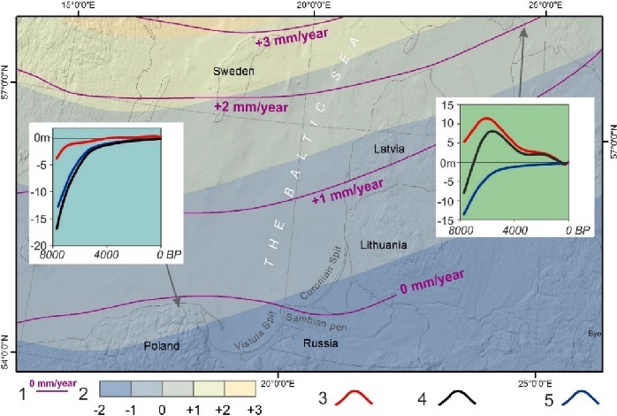
Fig. 1. Vertical crustal displacement (mm/year) for the twentieth century: 1 – isobases by [23]; 2 – isobases by [24]. Graphs: 3 – the isostatic component; 4 – relative sea level change; 5 – the eustatic curve.
The Late Pleistocene relief within the Baltic Proper in front of the Curonian Spit is rather dissected (Fig. 2), with several basins, ridges and narrow runnels. Runnels are up to 10 m in relative depth and are located within the Palaeo-Neman area and most likely have an erosion origin. The Late Pleistocene surface within the Curonian Lagoon is subdivided into two separate basins. Many modern relief features are inherited from the Late Pleistocene surface. GIS hydrological modelling allowed for the possible locations of palaeoriver valleys in the Early Holocene to be traced – linked with palaeo-Neman in the east, palaeo-Deima in the south and the third (southwestern) under the attached part of the Curonian Spit [25].
In the area of the Vistula Spit, deposits of Weichselian glaciation and Late Pleistocene postglacial basins were one of the few remaining occurrences of significantly reduced thickness, mainly sands with gravel. Their surface is eroded, and the degree of destruction increases in the eastern direction. Late Pleistocene deposits are identified in the Sztutowo area at -20-16 m b.s.l. and in the Przebrno area at -21-20.5 m b.s.l. [13].
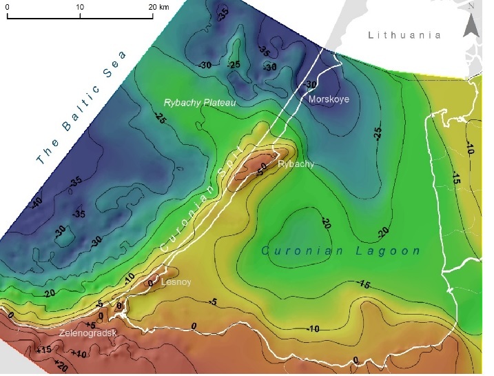
Fig. 2. Model of Late Pleistocene relief (m m.s.l.)
In the Early Holocene, as a result of the final drainage of the BIL, the water level dropped by -55-60 m b.s.l. within its southwestern part [12], [14] and the Baltic Basin was connected with the ocean, forming the Yoldia Sea. The next palaeobasin – the fresh-water Ancylus Lake – was formed after a 25 m transgression caused by a glacioisostatic rebound [12]. The level of Ancylus Lake in Gdansk Bay reached -20 m b.s.l. by the end of Early Holocene. To the north-east of the Sambian Peninsula, deep-water facies of Ancylus Lake are found at a sea water depth of -80 m b.s.l. [15], [16].
Significant differences were revealed in the Holocene geological settings of the Curonian and Vistula Spits. The thickness of Holocene deposits within the Russian part of the Curonian Spit increases from the southwest to the northeast from 1-5 m to 40-80 m (under dune massifs). Along some areas in the attached part of the spit and in the vicinity of Rybachy village, their thickness is less than 1 m [25]. On the contrary, Holocene deposits of the Vistula Spit are characterized by a consistent thickness of approximately 20 m.
In the boreholes located in the Russian part of the Curonian Spit, Early Holocene deposits are absent, with the exception of the southern part of the spit in the vicinity of Morskoye village [4], where they are represented by unsorted sands. In the Lithuanian part of the Curonian spit and the lagoon, a surface of Early Holocene deposits, submerging seaward, are located at a depth from -6 to -10 m b.s.l., with local valleys up to -15..-20 m b.s.l. [22].
The best preserved areas of Ancylus Lake deposits according to borehole data are found in the Curonian Lagoon [10]. They are represented by sand with the surface established at a depth from -4 to -18 m b.s.l., with decreasing thickness in the eastern and southern directions. Along the eastern and southern coasts of the Curonian Lagoon, the thickness of Ancylus deposits is less than 1 m and completely absent within the Neman delta plain.
Palaeoreconstructions of the Curonian Spit area during the Holocene based on this research are shown in Fig. 3. According to the data on the Ancylus Lake level [1], [7], [14], it is can be concluded that palaeorivers were the main source of sediment material for deposition within the Curonian Lagoon basin during the Early Holocene within the Baltic Basin shoreline of the Ancylus Lake located near modern isobaths of -60 m. Small fresh-water lakes could have been located in the bottom depressions of the central part of the Curonian Lagoon. In the northern part of the Curonian Lagoon that was connected to the open part of the Baltic Basin during the period of the lowest water level, deltaic sand accumulation occurred.
During the first stage of the Litorina Sea development, the coast line was located at a depth of -25 m b.s.l. An isolated fresh-water lake occurred in the Curonian Lagoon Basin. During the maximal phase of the Litorina transgression (about +3 m a.s.l.), the Curonian Spit plateau and ridges and the Rybachy Plateau were submerged. The Curonian Lagoon area was an open bay of the Litorina Sea, possibly partly separated by several small islands. Due to active hydrodynamics, bottom erosion and redeposition of sediment material dominated within the study area after the maximal phase of the Litorina transgression.
Investigations of the Baltic Sea bottom along the southern half of the Curonian Spit using side-scan sonar, multibeam echosounder, seismic imaging, sediment sampling, and video observations allowed for the identification and mapping of a unique underwater landscape formed by extensive outcrops of laminated and folded lagoon marl at water depths of 5 to 15 m. The relict lagoon marl was deformed, compacted, and dehydrated by a massive dune-covered coastal barrier migrating landward (retrograding) over these sediments during the Litorina Sea transgression in a process termed “dune tectonics”. Offshore lagoon marl ridges form an extensive complex that was approximately 5 m (up to 8-10 m) thick; modern marine sands [26] cover the described complex. A conceptual palaeogeographic model of the relict lagoon marl extrusions (diapirs) on the underwater coastal slope of the Curonian Spit is shown in Fig. 3 (7500 ka BP).
Along the marine coast of the Curonian Spit in the vicinity of Zelenogradsk, Lesnoy and Rybachy, peat and palaeosols layers were found at a depth of approximately -1 m b.s.l. Radiocarbon dating results have shown that during the last 5000 years, slow shifting of the spit toward the lagoon due to the increasing sea level was the main Curonian Spit development trend [27].
Consequently, the Curonian Spit developed during the Holocene on a postglacial surface (e.g., glacial moraine ridges remain) as a polygenic accretion form. During the first stages of the Curonian Spit development (regressive phase after the Litorina transgression maximum), both cross-shore and longshore sediment transport were sources of sediment material, as a result of the erosion of the Sambian Peninsula, Rybachy Plateau and deltaic sediments. The smoothed contour of the spit shoreline formed during the last 5000 years as a result of longshore sediment drift.
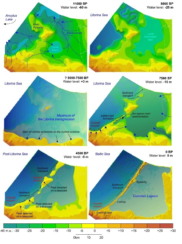
Fig. 3. Palaeogeographical reconstruction of Holocene development of the Curonian Spit area [25].
The geological setting and postglacial history of the Vistula Spit area, according to [12], [13], [14], are completely different, as was earlier mentioned by [28]. There are only subaerial lacustrine–swampy or alluvial–deltaic complexes beneath the modern silty sediments of the gulf, whereas marine complexes are completely absent. Therefore, the Vistula lagoon has never been open to the Litorina Sea. An important feature of the Vistula Delta Plain and area under the Vistula Spit is a consistent biogenic layer, deposited between 9120 and 7330 kal years B.P. The palaeoenvironment of this long-term biogenic accumulation is interpreted as a large plain with channels and shallow swamps and peat logs in depressions. Within Vistula Spit, this layer is covered by marine Litorina sands and dunes [13].
According to detailed palaeoreconstructions [14], during the existence of Ancylus Lake, the coastline was situated below the recent sea level within the Gdansk Basin, forming a vast open bay with advanced palaeo-Vistula deltas. As a result of deltaic deposit erosion, extensive barrier beaches formed in the coastal zone and aeolian processes started. During Early Litorina time, the shoreline shifted landward within the central part of the recent Vistula Lagoon and the small, partly isolated lake occurred. During the Litorina transgression (by 8000 kal years BP), the coastline shape first became similar to the modern one. Hel Spit developed; the Vistula Lagoon became separated from the sea by the Vistula Spit, probably by several palaeostraits. Approximately 2500 kal years BP the area of the lagoon was larger than it is today [14].
It is noteworthy that numerous datings and other geological evidence support this concept. However, some geological survey results in the Russian part of the Vistula Lagoon coasts map marine Litorina sands at an altitude of 2 to 5 m, and hypotheses on the formation of the palaeo-lagoon marl of the Vistula Spit also differ. It should be mentioned that the Russian part of the Vistula Lagoon is much less studied in comparison with the Polish part. To fill in these gaps in knowledge, further investigation is needed.
Modern lithodynamic processes
Analysis of materials and data confirmed that most of the transported sediment forming the total sediment flux migrated within the coastal zone of the Sambian Peninsula and that the Curonian Spit consists of products of coastal and bottom erosion, although one of the particularities of the Gdansk basin is a predominance of the river load in its sediment balance. The explanation for this is that first, the equilibrium profile is still under formation and erosion processes are taking place there and, second, the Vistula and Curonian lagoons act as traps for fluvial sediments. As was previously observed, such fluvial sediment flux plays an important role in the Vistula Spit sediment balance.
Complex erosion and accumulation processes leading to the smoothing of irregularities along the coastline (bays, capes) is the modern development tendency of Kaliningrad region coasts. The common pattern of longshore sediment transport described in the literature depicts two sediment fluxes directed to the north-west and southeast from the Sambian Peninsula (Cape Taran). On an underwater slope of the northern part of the Sambian Peninsula and the Curonian Spit, sandy material migrates within so-called morpho-lithodynamic cells [29]. The McLaren method [30] was applied to determine the sediment transport direction of the underwater slope restricted by isobaths -30 m (zone of active wave influence) [31]. The results show that sediment movement depends on the morphological properties of the coastal zone – points of flux divergence are associated with capes; outcrops of moraine and pre-quaternary deposits are a source of material to be transported.
- CONCLUSIONS
Synthesis of long-term geological research in the Russian part of the southeastern Baltic and its coastal zone allowed for boundaries, the time of formation and the structure of the Sambian morpho-lythodynamic marine and coastal system to be established. New geological and geophysical data enabled palaeogeographical schemes of the Holocene development of the Curonian Spit area to be produced. Comparative analyses of the Curonian and Vistula Spits areas revealed significant differences regarding their development in the Late Pleistocene and Early Holocene, when the coastal zone of the study area consisted of several morpho- lithodymanic systems.
The Curonian Spit developed during the Holocene on a postglacial surface (e.g., glacial moraine ridges remains) as a polygenic accretion form. During the first stages of Curonian Spit development (the regressive phase after the Litorina transgression maximum), both cross-shore and longshore sediment transport were sources of sediment material as a result of the erosion of the Sambian Peninsula, Rybachy Plateau and deltaic sediments. The smoothed contour of the spit shoreline was formed during last 5000 years, mostly as a result of longshore sediment drift.
The Vistula Spit area, according to [14], was located onshore by the time of the Litorina transgression when the coastline shape first became similar to the modern one. The Hel Spit developed and the Vistula Lagoon became separated from the sea by the Vistula Spit, most likely with several palaeostraits [14].
Consequently, the lagoon systems of the south-eastern Baltic became morphologically similar during the last 5000 years when the Curonian and Vistula Spits and lagoons had similar configurations; the lagoons became sediment traps for the alluvial material of the Neman, Vistula and Pregola Rivers; and longshore and sediment transport became one of the most important coastal processes of these marine shores.
The work was supported by the Russian Scientific Fund (grant 14-37-00047).
1. A.I. Blazhchishin, “Flooded Dunes and Deposits of Construction Materials on the Sea Underwater Slope of the Curonian Spit,” Problems of Investigation and Protection of Nature at the Curonian Spit, pp. 59-67, 1998, in Russian.
2. V.L. Boldyrev and O.I. Ryabkova, “Coastal Zone Processes Dynamics of the Baltic Sea (Kaliningrad Region),” Proc. Rus. Geographical Soc., vol.133. no.5, pp. 41-48, 2001, in Russian.
3. G.S. Kharin and S.G. Kharin, “Geological Structure and Composition of the Curonian Spit (Baltic Sea),” Lithology and Miner. Resources, vol. 41, issue 4, pp.3 17-323, 2006.
4. E.N. Badyukova, L.A. Zhindarev, S.A. Lukyanova and G.D. Solovyeva, “Curonian Spit: Genesis and Development,” Quaternary International, vol. 167, pp. 21-27, 2007.
5. L.A. Zhindarev, O.I. Ryabkova and V.V. Sivkov, “Geology and Geomorphology of Marine Coasts,” Oil and Environment of Kaliningrad Region, vol. II: Sea, pp. 19-37, 2012, in Russian.
6. A. Bitinas, R. Zaromskis, S. Gulbinskas, A. Damusyte, G. Zilinskas and D. Jarmalavicius, “The Results of Integrated Investigations of the Lithuanian Coast of the Baltic Sea,” Geology, Geomorphology, Dynamics and Human Impact. Geological Q., vol. 49 (4), pp. 355-362, 2005.
7. A. Damušytė, “Post-glacial Geological History of the Lithuanian Coastal Area,” Summary of doctoral dissertation, Vilnius, 84 p., 2011.
8. Zh. Gelumbauskaite, “Methods and Results Study of Ancient Coastal Levels Deformations of the SE Baltic Sea,” Baltica, vol.7, pp. 95-104, 1982.
9. V.K. Gudelis, L.S. Lukoshevichus, G.I. Klejmenova and E.M. Vishnevskaya, “Geomorphology and Late-after-glacial Bottom Sediments of the South-eastern Baltic,” Baltica, vol.6, pp. 245-256, 1977, in Russian.
10. M. Kabailienė, “Kursiu Nerija Spit and the Kursiu Marios Lagoon: Geological Structure, Origin and Development During Late Glacial and Holocene,” Abstr. Excursion Guide, The fifth marine geological conference «The Baltic», pp. 134-142, 1997.
11. O. Pustelnilovas, “The Development of Kursiu Marios Lagoon on the Sedimentological Data,” Abstr. Excursion Guide, The fifth marine geological conference «The Baltic», pp. 149-155, 1997.
12. J. E. Mojski, “The Evolution of the Southern Baltic Coastal Zone,” Oceanologia, vol.42, no.3, pp. 285-303, 2000.
13. A. Tomczak, “Geological Structure and Holocene Evolution of the Polish coastal zone,” J. Coast. Res., no. 22, pp. 15-32, 1995.
14. S. Uscinowicz, “Relative Sea Level Changes, Glacio-isostatic Rebound and Shoreline Displacement in the Southern Baltic,” Pol. Geological Inst. Special Papers, vol.10, 79 p., 2003.
15. V.A. Zagorodnyh, T.A. Kunaeva, “Geology and Economic Deposits of Kaliningrad region,” 171 p., 2005, in Russian.
16. Atlas of Geological and Environmental Geological Maps of the Russian Area of the Baltic Sea, Editor O.V. Petrov, St. Petersburg, VSEGEI, 78 p., 2010, in Russian.
17. N.V. Lukyanova, Y.B. Bogdanov, O.V. Vasiliev, G.P. Vargin, V.R. Verbitsky, N.R. Gorbatsevich, et al., “State Geological map of the Russian Federation,” 1:1 000 000 scale (third generation). Central European Series. Sheet-N-(34) - Kaliningrad. Explanatory note, St. Petersburg, VSEGEI, 226 p., 2011, in Russian.
18. A.I. Blazhchishin, V.L. Boldyrev, A.N. Efimov and I.A. Timofeev, “Ancient Coastal Levels and Formations in the South-eastern Baltic Sea,” Baltica, vol. 7, pp. 57-64, 1982, in Russian.
19. Sivkov, D. Dorokhov and M. Ulyanova, “Submerged Holocene Wave-Cut Cliffs in the South-eastern Part of the Baltic Sea: Reinterpretation Based on Recent Bathymetrical Data,” The Baltic Sea Basin, Cent. East. Eur., pp. 203-217, 2011.
20. B.G. Anderson and H.W. Borns, The Ice Age World, Scandinavian University Press, Oslo, 208 p., 1994.
21. I.I. Krasnov, K. Duphorn and A.Vogese, “International Quaternary Map of Europe,” scale 1:2500000, 1971.
22. L. Ž. Gelumbauskaitė, J. Šečkus, “Late-Glacial-Holocene History in Curonian Lagoon (Lithuanian sector),” Baltica, vol. 18, no.2, pp. 77-82, 2005.
23. J. Harff and M. Meyer, “Coastlines of the Baltic Sea - Zones of Competition Between Geological Processes and a Changing Climate: Examples from the Southern Baltic,” The Baltic Sea Basin, Cent. East. Eur., pp. 149-164, 2011.
24. O. Vestøl, “Determination of Postglacial Land Uplift in Fennoscandia from Levelling, Tide-gauges and Continuous GPS Stations Using Least Squares Collocation,” J. Geodesy, no.80, pp. 248-258, 2006.
25. A.Yu. Sergeev, “The Palaeogeographical Reconstruction of the Curonian Spit Area in the Late Pleistocene - Holocene,” Reg. Geology Metallogeny, no. 62, pp. 34-44, 2015, in Russian.
26. A. Y. Sergeev, V. A. Zhamoida, D. V. Ryabchuk, I. V. Buynevich, V. V. Sivkov, D. V. Dorokhov et al., “Genesis, Distribution and Dynamics of Lagoon Marl Extrusions along the Curonian Spit, Southeast Baltic Coast,” Boreas,https://doi.org/10.1111/bor.12177. ISSN 0300-9483.
27. A. Sergeev, V. Sivkov, V. Zhamoida, D. Ryabchuk, A. Bitinas and J. Mažeika, “Holocene organic-rich Sediments within the Curonian Spit Coast, the South-eastern Baltic Sea,” Baltica, , vol.28, no.1, pp. 41-50, 2015.
28. E.N. Badyukova, L.A. Zhindarev, S.A. Lukyanova and G.D. Solovyeva, “The Geological-geomorphological Structure of the Baltic (Vistula) Spit,” Oceanology, vol. 51, no. 4, pp. 632-639, 2011.
29. A.N. Babakov, “Evolution of Ideas about Structure of Long-shore Sediment Transport in the South-eastern Baltic,” Lithodynamics of Ocean Bottom Contact Zone, pp. 56-58, 2009, in Russian.
30. P. McLaren and D. Bowles, “The Effects of sediment transport on grain-size distributions,” J. of Sediment. Petrology, vol.55, no.4, pp. 0457-0470, 1985.
31. E.V. Dorokhova and D.V. Dorokhov, “Sediment Mapping and Transport Pathways in the Nearshore Zone of the Russian part of South-Eastern Baltic Sea,” EMECS’11 - SeaCoasts’26 Conference Proc., 2016, in press.