


BISAC NAT010000 Ecology
BISAC NAT045050 Ecosystems & Habitats / Coastal Regions & Shorelines
BISAC NAT025000 Ecosystems & Habitats / Oceans & Seas
BISAC NAT045030 Ecosystems & Habitats / Polar Regions
BISAC SCI081000 Earth Sciences / Hydrology
BISAC SCI092000 Global Warming & Climate Change
BISAC SCI020000 Life Sciences / Ecology
BISAC SCI039000 Life Sciences / Marine Biology
BISAC SOC053000 Regional Studies
BISAC TEC060000 Marine & Naval
The northern Shikoku region is located in the Western part of Japan and faces towards the Seto Inland Sea. The forest area, which is one of the non-point sources in the Seto Inland Sea watershed, occupies 75% of the land use in the watershed of the northern Shikoku region. The amount of loadings of nutrients and COD in the Seto Inland Sea has been estimated by the unit load method but actually the data has not been investigated. It is however, necessary to know the real concentration of nitrogen in mountain streams to evaluate the role which is the mountain area plays as non-point sources. Therefore, more water samples of mountain streams in the watershed need to be taken and the concentrations of nitrogen analyzed. The mountain streams in the northern Shikoku area were investigated from April, 2015 to November, 2015. The number of sampling sites was 283, in addition to the past data by Kunimatsu et al. The average concentration of nitrate nitrogen in Ehime, Kagawa, and Tokushima was 0.61mg/L, 0.78mg/L and 0.34mg/L, respectively. The environmental standard range for nitrogen in the Seto Inland Sea is from between less than 0.2mg/L and less than 1mg/L. Therefore, the average concentration of nitrogen in these regions was over category II, and those of mountain streams in Kagawa Prefecture exceeded category III. About 20% of mountain streams were more than 1mg/L. It has become clear that mountain areas occupy an important position as non-point sources for the Seto Inland Sea.
Mountain Stream, Nitrate Nitrogen, Non-Point Source
I. INTRODUCTION
The water quality in the Seto Inland Sea had been polluted through the postwar period of the high growth of economy in Japan. A lot of measures have been achieved to protect water pollution and conserve the water environment based on the Act on Special Measures concerning the Conservation of the Environment of the Seto Inland Sea since 1973 [1]. The loadings of pollutants have been cut and number of red tide occurrence decreased [2]. On the other hand, the fishery production has shown a tendency to decrease [2]. It is the contemporary subject how to generate the bountiful Seto Inland Sea. Therefore, it is necessary to know the present condition on the nutrients loadings in the Seto Inland Sea. Among the point and nonpoint sources, the loadings of nutrients from nonpoint sources have been estimated by the unit load method, but actually the data has not been investigated. It is, however, necessary to know the real concentration of nitrogen in the mountain streams. The loadings from the forest area would largely contribute in total loadings to the Seto Inland Sea, because forest area occupies 67% of land use in Japan and 75% in the watershed of the northern Shikoku region which is the investigation area in this study, too.
The northern Shikoku region is located in the Western part of Japan and faces towards the central Seto Inland Sea, in which includes the Sea of Suo, the Sea of Iyo, the Sea of Aki, the Sea of Hiuchi, Bisan Strait, the Sea of Bingo, and the Sea of Harima. It is, however, necessary to know the real concentration of nutrients in mountain streams to evaluate the role which is the mountain area plays as the non-point sources. The concentration of nitrogen in the mountain stream water in Shikoku region investigated in 2004 by Konohira et al. It is, however, difficult to estimate the loadings of nutrients from forest area by their results, because the number of water samples were less than 77 in the same area.
In this study, we collected the mountain stream samples as many as possible in the widespread area, and investigate the concentration and characteristics of the distribution of the nitrogen concentration in the forest area. Based on these results, we evaluated a role of forest which plays as the nonpoint source for the Seto Inland Sea.
II. METHOD
Study area
The study area is shown in Fig.1. Most of Ehime Prefecture, Kagawa prefecture and a part of Tokushima Prefecture face towards the Seto Inland Sea except for the Bungo Channel and the Kii Channel. The watershed area is about 5500km2 in Shikoku region. The population of six major cities, which are Matsuyama, Imabari, Niihama, Shikokuchuo, Sakaide and Takamatsu, are from about 40,000 to 500,000. Moreover, the population of Matsuyama and Takamatsu occupy more than 60% of these area.
An industrial area concentrates in Takamatsu and the neighboring areas. In addition, pulp and paper industry in Kagawa Prefecture is located near Ehime Prefecture. The land use is forest (75%), farmland (12%), and urban (9%).
The northern Shikoku region is Setonaikai climate division, which is warmer and less precipitation. The annual average temperature is about 17°C (about 16°C in the whole Japan) and annual average precipitation is 1300mm/year (about 1,700mm/year whole Japan). The geology in the study area mainly consists of the granite named Ryoke zone, the rhyolite named Izumi Group, the metamorphic rock named Sanbagawa metamorphic belt. The median Tectonic Line divides into Ryoke zone and Izumi Group in the eastern region, moreover the sedimentary and the Sanbagawa metamorphic belt in the eastern region. The main vegetation is Japanese cedar, Japanese cypress, Sawara cypress, and Japanese red pine.
The elevation of sampling sites is between about 30m to 1,010m, and the average was 339m. The Shikoku Mountains, which continues for about 90km from west to east and separate the northern and southern part of Ehime Prefecture. The Asan Mountains is a watershed between Kagawa and Tokushima Prefecture. The catchment areas of the each site were between less than 0.01km2 and 7.2km2. The average of the catchment area was 0.69km2.
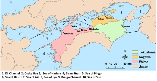
Fig.1 the sea areas in the Seto Inland Sea
Analytical items and methods
The mountain streams in the northern Shikoku area were investigated from April, 2015 to November, 2015. The sampling sites, which did not have any influence by anthropogenic pollution in upper watershed, were 283 in total, in addition to data by Kunimatsu et al.
The analytic items were nitrate nitrogen (NO3-N) by a flow injection analysis method and total nitrogen (TN) by the TN analyzer, in addition to pH, electrical conductivity (EC), alkalinity (pH4.3), and cation of major ionic species by ICP-AES.
Geographical features of sampling sites in Shikoku region, Japan
Fig. 2 shows the concentration of NO3-N and the elevation in the Shikoku region. The sites that had a high concentration of NO3-N were distributed around the “Median tectonic line” and the coastal area of “Takanawa Peninsula,” which is located in the northwest of Shikoku region. Conversely, sampling sites that had a low concentration of NO3-N were distributed more in the Western of Shikoku region. The point that had the highest concentration of NO3-N was located in the eastern part of the Shikoku region, the elevation of that point was about 40m and the catchment area was small.
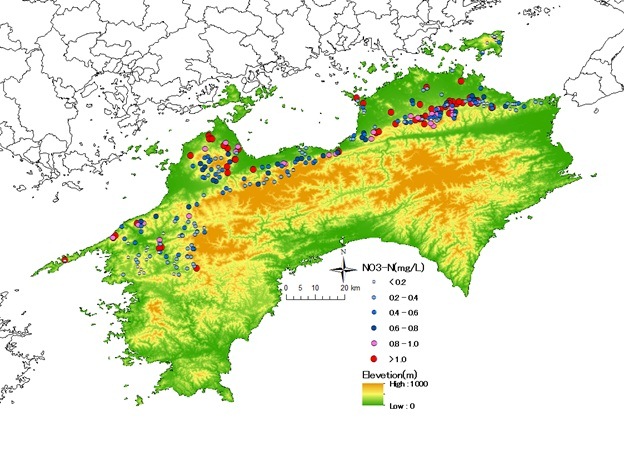
Fig. 2 Distribution of the NO3-N and the elevation in the Shikoku Region, Japan.
III. RESULT & DISCUSSION
The number of samples included the samples taken by Kunimatsu et al. were 156, 124, and 3 in Ehime, Kagawa, Tokushima, respectively. Table 1 shows the results of the NO3-N and TN in each areas. The average of concentration of NO3-N was 0.68mg/L, 0.61mg/L, 0.78mg/L, and 0.34mg/L in the Shikoku region, Ehime, Kagawa and Tokushima, respectively. The numbers of the sampling sites in the northern part of Shikoku region that more than 1.0mg/L of NO3-N were 55 (20%), and 20 (13%) in Ehime Prefecture and 35 (28%) in Kagawa Prefecture. Any sites in the Tokushima Prefecture were less than 1.0mg/L of NO3-N. The NO3-N has occupied more than 80% of the TN and the nitrogen has existed as the NO3-N in the mountain stream water.
These results show that the southeast part of the Sea of Harima has been not received the loadings of nitrogen from the forest areas.
Table 1. The results of NO3-N and TN in the each areas. 1); the number of points more than 1.0mg/L of NO3-N in this study. 2); the percentage of the points more than 1.0mg/L of NO3-N among all sampling points in this study. 3); the average concentration of NO3-N in the Konohira study. 4); the number of sampling points in the Konohira study. 5); the number of points more than 1.0mg/L of TN in this study. 6); the percentage of points more than 1.0mg/L of TN among all sampling points in this study. 3), 4) shows the result of Konohira study, but which has researched in the whole Shikoku region.
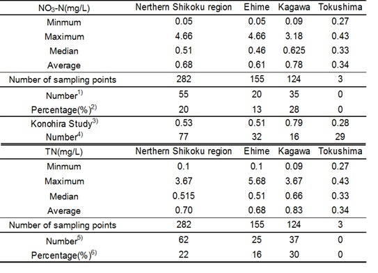
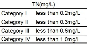
Table 2 shows the environmental standards for the TN in the Seto Inland Sea. The environmental standards for TN in the Seto Inland Sea, which faces towards the Shikoku region that is the investigation area in the study is category II, which is less than 0.3mg/L. The 82% of the mountain streams have exceeded the environmental standards for TN in the Shikoku region. As the average value of the NO3-N in the mountain stream water in the northern part of the Shikoku region was 0.68mg/L and the median was 0.51mg/L, the concentration of the TN is more than these values. Especially, the average concentration of TN in Kagawa Prefecture was 0.83mg/L, which was more than 0.6mg/L of category III at least. In addition, 30% of total sites in Kagawa Prefecture were more than 1.0mg/L of TN, which is the environmental standard in category IV. These results suggest that mountain stream is one of source of the nitrogen to coastal sea in the northern Shikoku region at least, even though these forested watersheds are not affected by any anthropogenic activities.
Table 2. The environmental standards for TN in Seto Inland Sea
IV. CONCLUSION
The average concentration of nitrogen in these regions was over category II, and those of mountain streams in Kagawa Prefecture have exceeded category III. About 20% of mountain streams were more than 1mg/L. It has become clear that mountain areas occupy an important position as non-point sources for the Seto Inland Sea. As the loadings of nitrogen have not been estimated, the contribution of forest area to total loadings of nitrogen in the Seto Inland Sea is unknown. It is necessary to evaluate a discharge and loadings of nitrogen in the each small forest watershed.
VI. ACKNOWLEDGMENT
This study was supported by JSPS KAKENHI Grant No. 15K00570.
1. Ministry of the Environmental, “Wide Area Comprehensive Water Survey,” pp. 8 - 15, 20 - 28, 2013, Ministry of the Environmental, http://www.env.go.jp/water/suiiki/h24/full.pdf
2. Setouchi fishery adjustment office, “Red Tide in the Seto Inland Sea (1971 - 2015),” Setouchi fishery adjustment office, http://www.env.go.jp/water/suiiki/h24/full.pdf
3. E. Konohira, J. Shindo, and T. Yoshioka, “Stream water chemistry in Japan,” Japanese Association of Hydrological Sciences, Japan, vol. 36(3), pp. 145-149, 31th August 2006
4. Ministry of Land, Infrastructure, Transport and Tourism, “Land White Paper”