


BISAC NAT010000 Ecology
BISAC NAT045050 Ecosystems & Habitats / Coastal Regions & Shorelines
BISAC NAT025000 Ecosystems & Habitats / Oceans & Seas
BISAC NAT045030 Ecosystems & Habitats / Polar Regions
BISAC SCI081000 Earth Sciences / Hydrology
BISAC SCI092000 Global Warming & Climate Change
BISAC SCI020000 Life Sciences / Ecology
BISAC SCI039000 Life Sciences / Marine Biology
BISAC SOC053000 Regional Studies
BISAC TEC060000 Marine & Naval
For a long period of time, the seashore has been eroded and the front dune has been intensely degrading in the area of the Vistula Spit south of the Baltic Strait, connecting the Vistula Lagoon and the Baltic Sea. This leads to the fact that Kosa settlement which is directly behind the front dune gets flooded during the storm events. The settlement was already flooded three times - in December 2011, January 2012 and December 2013. This article aims to provide a substantiation of the critical condition of the northern segment of the Vistula Spit seacoast.
coastal erosion, monitoring data, coastal protection, Vistula Spit, Baltic Sea
- Substantial of the critical condition of the segment
The Vistula Spit is located in the south-eastern part of the Baltic Sea and is a narrow strip of land 65 km long, 35 km of which (25 km south of the Baltic Strait and 10 km north of it) are situated on the Russian territory and called "The Baltic Spit". The spit is divided in the north by the Baltic Strait of 400 m wide and 8-12 m deep. [1]. Protective breakwaters of the strait are an obstacle for the natural alongshore movement of sand drifts [2].
Starting from September 1, 1995, the Baltic Spit became available for free visiting for Kaliningrad region residents. At that time, the transportation was performed by a military ferry and it was free of charge. Since 2007, the "Baltic Shipping Company" has launched the private ferry "Baltiysk – the Baltic Spit", which effected carriage 7 times a day at first and then 8 times a day. After the ferry was launched, according to the "Baltic Shipping Company", the flow of visitors to the Baltic Spit increased dramatically.
Currently, the landscape of the major part of the Vistula Spit consists of the front dune, followed by a more ancient coastal dune ridge, usually consisting of two elongated banks. The banks are often split into separate parabolic dunes, approaching the plains located behind them like vast tongues [3]. Almost the entire surface of the spit is covered with woodland.
It should be noted that the northern tip of the Vistula Spit is different in terms of landscape from the rest of the spit, related to the increased anthropogenic influence thereon. Instead of the forests, this area is detected by a low degree of tree and shrub vegetation, and the surface of the front dune is heavily indented by deflationary basins.
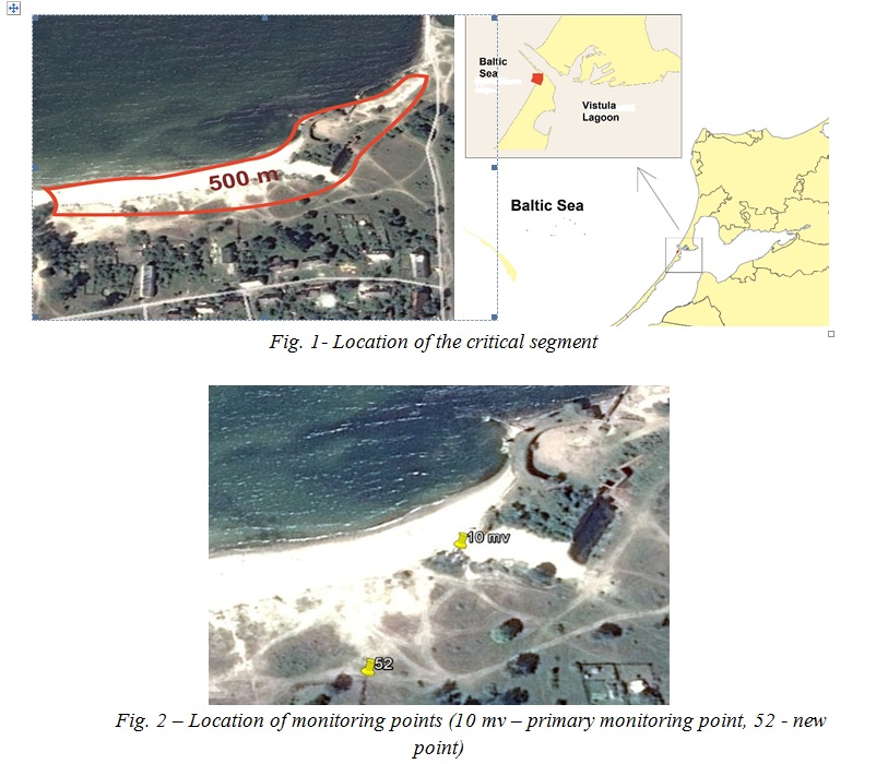
This segment of the spit is most strongly exposed to erosion and has been recognized as critical for the past 15 years, both in terms of the front dune degradation, which is considerably above the average retreat rate at the Vistula Spit, and due to the flooding threat for residential buildings of Kosa settlement, located directly behind the front dune. The critical coastal area is represented by the severely degrading front dune of 500 km long and the adjacent beach. [4]
Shore dynamics monitoring
Shore dynamics in the village of Kosa has been annually specified, from 2003 to 2016 [5, 6]. From 2003 to 2007, the observations were carried out by IO RAS. In 2007, the monitoring point had to be moved inland (Fig. 2), as due to the high rate of the coast erosion, it actually found itself on the beach within 5 years. Further observations were continued at the new monitoring point of the State Organization of the Kaliningrad region "Baltberegozaschita". In 1999, a relatively low coastal dune protecting Kosa settlement from storm waves located on a flat plain was intensely eroded during a storm. [7]
Over the following years, the trend of the coastal abrasion continued, as evidenced by monitoring observation data collected by IO RAS. According to the monitoring data collected from 2003 to 2006, the front dune base moved more than 4.5 m. (Fig. 3a)
On the average, the retreat amounted to -1.1 m / per year, which is higher than the average retreat rate of the front dune retreat at the Vistula Spit, equal to -0.35 m / per year.
Between 2007 and 2015, the base of the sea slope of the front dune retreated nearly by 10 m, the average retreat rate also accounted for -1.1 m / per year. (Fig. 3 b,c). The average beach width remained almost unchanged within the range of 20-30 meters.
The diagram (Fig. 4) shows the way the position of the top and bottom of the sea slope of the front dune, as well as the shoreline from the permanent monitoring point changed between 2007 and 2015.
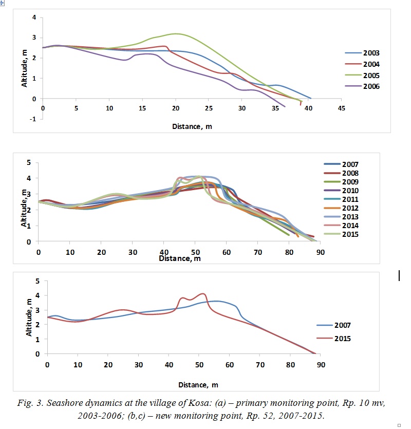
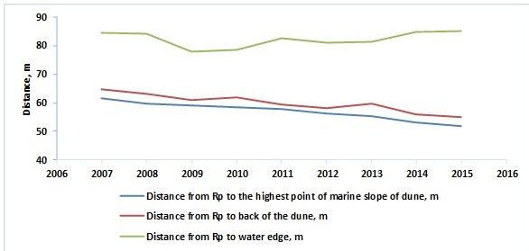
Fig. 4 – Diagram of the change of the seashore position near the village of Kosa between 2007-2015
Assessment of anthropogenic load influence on the segment
Since 2007, the anthropogenic load on the critical segment has increased due to the launch of the private ferry along the route "Baltijsk – the Vistula Spit" instead of the military ferry running between 1995 and 2007. The private ferry began running through the Baltic Strait 7-8 times a day. Passenger traffic of tourists, according to the "Baltic Shipping Company", which was carrying out the transportation, increased between 2008 and 2015 by 17270 persons / per year, the number of imported vehicles increased by 3818 units / per year. (Fig. 5).
Most of the visitors are concentrated on the northern section of the Baltic Spit near the village; tourists use the deflation basins of the front dune as hills and drive down them to the beach by cars, thus increasing degradation of the front dune. (Fig. 6)
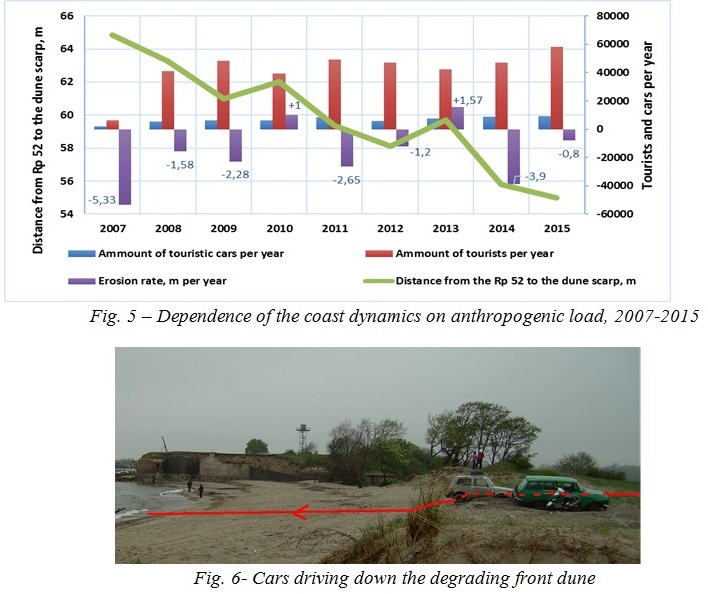
Destruction of the coast continued alongside with increase in the number of tourists visiting the Baltic Spit. However, despite the increase in tourists, the rate of the shore erosion has not increased, which means that the anthropogenic load has almost no effect on erosion of the front dune’s sea slope, but it mainly leads to increased deflation and surface degradation of the front dune body located outside of the wave field. The primary reason of the high rate of the front dune erosion is still storm impact and lack of sediment load related to the violation of beach drifting. As a result of degradation of the front dune body due to high anthropogenic load, deflation basins (washout) are formed through which the seawater enters and floods the territory of Kosa village. As a result of high rates of degradation, the volume of the front dune along about 500 m decreased by 25 126 m3 (the front dune in 2015 became 21.3% less than in 2007) between 2007 and 2015. [8].
- Flooding of the Village of Kosa
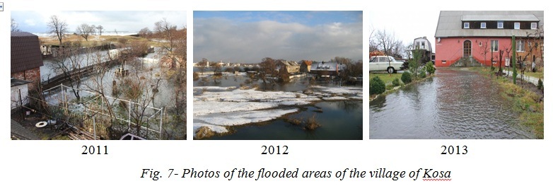
Increasing rates of the dune’s degradation led to the fact that the village of Kosa found itself in the flooding zone. The village was first flooded in November- December 2011, the next flooding happened in January 2012, and finally the village of Kosa was flooded for the third time in December 2013 during Xavier hurricane (Fig. 7).
The village of Kosa is located on a flat plain, so there is a threat of flooding of the major part of the village under extreme storm conditions through three main washouts in the front dune body (Fig. 8)
Fig. 8 – Scheme of sea waves’ outburst points on the territory of Kosa village
The flooding risk of Kosa village is determined by a combination of such factors as wind speed and direction, storm impact duration, as well as readiness of the shore segment for new hurricane waves (i.e. whether the coast managed to restore its margin of safety after enduring the previous storm).
As a result of the data of after-storm coast survey carried out by the State Unitary Enterprise and State-financed Entity "Baltberegozaschita" in the area of the critical segment between 1981 and 2013, a forecast of the area’s flooding was performed according to which one can presumably judge of the future flooding of the territory based on the storm duration and power data.
To assign the definition of "extreme" storm according to criteria of "Baltberegozaschita" to a storm impact on the coast of the Kaliningrad region, the following conditions shall be simultaneously fulfilled:
- wind speed 15 m / s or more;
- storm event duration more than 50 hours;
- dangerous wind direction in relation to the shoreline exposure, i.e. the wind direction when there is a chance of maximum shore erosion;
- sea level rise as a result of surges by 1 m or more.
In case when the wind speed is less than 15 m / s, but there is significant storm duration (80 hours) accompanied by a storm surge and significant coast erosion and abrasion, such a storm shall be also rated as "extreme".
According to the frequency of extreme storms occurrence on the coast of the Kaliningrad region in the twentieth century, their occurrence is determined according to basic parameters (wind strength and storm duration). Table 1 contains the data on major storms that happened over last 33 years.
Table 1- Major storms that happened over last 33 years
|
Years |
Wind speed, m/s |
Max. wind speed, m/s (gusts) |
Wind direction, rhumb |
Wave height, m |
Surge height, m |
Storm t, accumulative duration hours |
Occurrence, % |
Was the village of Kosa flooded? Duration? |
|
1983 |
35 |
45-50 |
SW, W, NW |
8 |
2,2 |
240 |
1 |
No |
|
1988 |
25 |
35 |
W, NW |
6 |
2,0 |
150 |
2 |
No |
|
1990 |
20 |
25 |
NW, W |
4 |
1,2 |
72 |
4 |
No |
|
1992 |
21 |
29 |
NW |
5 |
1,8 |
120 |
2 |
No |
|
1993 |
32 |
40-45 |
SW, WSW |
6 |
1,2 |
70 |
4 |
No |
|
1994 |
18 |
25 |
WSW, W, WNW |
4 |
0,8 |
40 |
10 |
No |
|
1999 |
30 |
40 |
NW |
6 |
1,1 |
130 |
2 |
No |
|
2002 |
30 |
34 |
W |
6 |
1,2 |
60 |
4 |
No |
|
2005 |
25 |
30 |
W |
3 |
0,6 |
20 |
20 |
No |
|
2007 |
25-27 |
35 |
W, NW |
4 |
1,2 |
72 |
4 |
No |
|
2011 |
20 |
24 |
SW, W |
3,5 |
0,8 |
12 |
20 |
Yes. Up to 100 m. |
|
2012 |
13-15 |
25 |
W, NW, N |
3,5 |
0,8 |
80 |
10 |
Yes. Up to 150 m |
|
2013 |
13-18 |
25-30 |
SW,W |
3,5-4,5 |
0,6 |
70 |
20 |
Yes. Up to 170 m |
|
Jnr 2015 |
13-18 |
25-30 |
W, NW |
4-5 |
0,5 |
24 |
50 |
No |
|
Nov 2015 |
12-16 |
20-22 |
NW |
3 |
0,3 |
12 |
100 |
No |
According to the data presented in Table 1, it is clear that the strength reserve of the front dune in the sea area of Kosa village reached a critical value in 2011. Now, even during a storm of 20% occurrence happening over the coast of the South-Eastern Baltic region and conditioned by the action of west winds, the village of Kosa may be flooded. In case of storms of greater strength, flooding of the village is inevitable.
In order to determine the extent of possible damage, a technique for damage determination was used in relation to the harm that can be caused to life and health of individuals, property of individuals and legal entities as a result of an accident of a hydraulic structure [10], since there are no existing methods to determine the possible damage resulting from flooding due to the front dune erosion under storm conditions.
At the first preliminary phase, a possible scenario of the most severe accident was made, which considered the impact of 1% occurrence storm, which appears 1 time in 100 years. Such a storm with the maximum wind strength of 45 m / s and about 10 days duration eroded and broke through the front dune on the 2nd km of the Curonian Spit in 1983. The maximum length of sea water entering the Curonian Spit was the root of more than 500 m. [11]
The studied area of the Vistula Spit with similar characteristics of 1% storm with the west wind most dangerous for this segment under existing conditions of the degrading front dune (similar to the one at the Curonian Spit) assumes flooding of the village of Kosa from the seaside by more than 500 meters. However, given the water rise in the channel, there could also be observed the splash of water and additional flooding of the village from the channel. The flooding zone includes an object of cultural heritage – the Swedish fort and 35 residential buildings, including a nursery school. The total number of people affected by the flooding of residential houses amounts to about 175 people.
At the second stage, the probable damage is determined in monetary terms. Monetary value of losses calculation as a result of an accident are grouped according to the indicators characterizing the socio-economic effects of hydraulic structures’ failures, and then added. According to this method, the damage caused by flooding of the village of Kosa during the impact of 1% occurrence storm shall be 2.1 billion rubles.
- Coastal protection proposals for the critical segment
In order to prevent flooding of the territory of the village pf Kosa at the critical segment, measures to eliminate the threat of an emergency should be urgently taken. The best option is a comprehensive approach that takes into account all the causes of the critical nature of the site and restoration of the natural landscape.
In this area, it is first necessary to restore and strengthen the strength reserve of the front dune. Strengthening of the front dune is possible in case of installation of an artificial nucleus made of either of precast concrete constructions (tetrapods) with stone filling, or geotubes. [12,13] into the front dune body. To secure the surface of the front dune and reduce development of deflation processes, plant turf vegetation planting and installation of wooden stands with brushwood flooring are proposed. Parameters of the front dune shall be calculated based on maximum hydrodynamic conditions of wave disturbance, maximum surge and splash. According to Regulation 32-103-97 [14] and taking into account climatic conditions of the sea coast of the Baltic Spit, the front dune should be at least 8 m high, not less than 500 meters long and 40 m wide. Parameters and facilities design can be adjusted in the process of design and survey works.
The second stage of coastal protection works includes artificial beach aggradation, which is, apart from coast protection functions of aesthetic and recreational value. Therefore, the proposed parameters of the artificial beach were defined taking into account the natural environment and recreational potential of the village of Kosa. The above-water part of the beach should be 60-70 meters wide, with the aggradation beach at least 600 meters long based on calculation of SanPiN 42-128-4690-88 [15], 5 m2 of beach for 1 person.
The next stage of the coast protection works is associated with a need to reduce the loss of natural erosion of the artificial beach. Such works include construction of beach supporting structures - cross dikes and alongshore breakwaters. All parameters of the beach supporting facilities, including their amount, permeability, length, depth and others should be defined by means of mathematical modeling. Conceptual proposals are shown in the diagram of Fig. 9. Estimated cost of construction of the proposed complex of coast protection facilities shall be 300-400 million rubles, well below the damage that may result from flooding of the village of Kosa in case of the extreme storm influence.
.jpg)
IV. Conclusions
The study has shown that the segment on the northern tip of the Vistula Spit is critical over a length of 500 m because of two reasons - a high rate of coast destruction and flooding threat of the residential village, located behind the degrading dune. The high rate of the coast destruction is caused by deficiency of shore sand deposits due to violations of alongshore beach drifting after extension of piers. Increased anthropogenic load on the shore segment contributes to degradation of the front dune and formation of deflation basins (washouts), through which the village is flooded.
To avoid the flooding situation in the critical area, measures to eliminate the threat of an emergency should be urgently taken. The best option is a comprehensive approach that takes into account all the causes of the critical nature of the site and restoration of the natural landscape. It is proposed to construct a complex of coast protection facilities with aggradation of the lost coastal areas, as well as marine infrastructure to organize movement of heaps of people across the front dune to the beach. The first step is to prevent emergencies by means of creating a nucleus in the front dune body with restoration of the full strength reserve of the very sand body of the front dune. The next stages of facilities complex construction and beach aggradation shall simultaneously provide a favorable environment for public recreation and maximum reduction of the risks of accidents on the shore caused a significant increase of the anthropogenic load and storm impact.
V. Acknowledgments
Technical facilitation of the study and problem identification was made with support of the theme № 0149-2014-0017 (supervisor – B. Chubarenko) of State Assignment of the P.P.Shirshov Institute of Oceanology of the Russian Academy of Sciences (2015-2017). Preparation of this article was made under the support of the Project No 14-17-00547 “A forecast development for evolution of accumulative Russian coasts of tideless seas”.
1. V.P. Bobykina, V.L. Boldyrev, "On the problem of conservation and sustainable development of sea coasts: Natural and industrial risks of coastal areas”. [Proceedings of the International Conference, Odessa, September 7-11, 2008]
2. V.P. Bobykina, “Seacoast morphology and dynamics of the northern segment of the Baltic Spit // Ecological issues of the Kaliningrad region and the Baltic region”. Kaliningrad: coll. scientific work. Publisher of Immanuel Kant Russian State University, 2007. S.20-26.
3. E.N. Badyukova, L.A. Zhindarev, S.A. Lukyanova, G.D. Solovieva, “Geological and geomorphological structure of the Baltic (Vistula) Spit. [The doctrine of the sea coast development: age-old traditions and ideas of modernity: Conference materials. - St. Petersburg: Russian State Hydrometeorological University, 2010. pp. 170-172]
4. O.V. Bass, L.A. Zhindarev, “Manmade accumulative landforms in the coastal zone of the South-Eastern Baltic region, Tr. Intern. Conf. “Creation and use of artificial land plots on the shores and water bodies territory” - Novosibirsk: Publisher of SB RAS, 2009. pp. 187-196.
5. Statistical data of the shore dynamics since 2000-2014. Monitoring of the critical segment in Kosa settlement. Data of State Public Entity of the Kaliningrad region “Baltberegozaschita”
6. Statistical data of the shore dynamics 2003-2006. Monitoring of the critical section. Data of IO RAS
7. V.P. Bobykina “On the extreme storm erosion of the coast of the Vistula Spit in December 1999, Scientific notes of the Russian Geographical Society (Kaliningrad branch). Kaliningrad, Publisher of Kazan State University, 2001, pp. 8A-1 - 8A-5
8. E.M. Burnashov, “Current dynamics and geo-ecological state of the sea coast of the Kaliningrad region: Cand. Sc. Geography: 25.00.06: approved on 15.07.2011.E.M. Burnashov - Barnaul, 2011, p 205.
9. K.V. Karmanov, E.M. Burnashov, V.Y. Glinka, A.Y. Komogorov, B.V. Chubarenko Topographic characteristics of dynamically active segments of the front dune of the Russian part of the Baltic.Vistula Spit, 2015.
10. RD 03-626-03. Methods of determination of the damage extension that can be caused to life and health of individuals, property of individuals and legal entities as a result of a hydraulic structure accident. - Introduced for the first time; introduced. 2003 10C.
11. O.I. Ryabkovа “The history of coastal protection at the Kaliningrad sea coast”. [Coastal zone: Morpholithodynamics and geo-ecology: Materials of the conf.Ed. Ed. Prof. V.V. Orlyonok. - Kaliningrad: Publishing House of the Kaliningrad State University, 2004,pp.273-275].
12. K.N. Makarov, Fundamentals of bank protection measures Sochi, SGUT and KD, 1999, p. 147
13. SNIP 33-01-2003. Hydraulic engineering structures. Main provisions. - Instead of SNIP 2.06.01-86; introduced on 30.06.2003. M .: Publisher of Standards, 2004. pp. 8.
14. SP 32-103-97: Regulation "Designing of marine coast protection facilities” Corporation "Transstroy", Moscow, 1998
15. SanPiN 42-128-4690-88 “Sanitary rules of maintenance of populated areas”.