


BISAC NAT010000 Ecology
BISAC NAT045050 Ecosystems & Habitats / Coastal Regions & Shorelines
BISAC NAT025000 Ecosystems & Habitats / Oceans & Seas
BISAC NAT045030 Ecosystems & Habitats / Polar Regions
BISAC SCI081000 Earth Sciences / Hydrology
BISAC SCI092000 Global Warming & Climate Change
BISAC SCI020000 Life Sciences / Ecology
BISAC SCI039000 Life Sciences / Marine Biology
BISAC SOC053000 Regional Studies
BISAC TEC060000 Marine & Naval
Coastal zones have great diversity of resources. The shallow water zones contain the most of plant and benthic communities. A description of relief and type of ground is needed for the rigorous monitoring of biota and environmental condition of coastal zone. Generally, on the basis of these data the investigation methods of the coastal zone are selected. The shallows research strategy has been developed by us for northern part of the Lake Ladoga. If the coastal areas are characterized by great depth and flat topography, then sonar’s can be used to describe them and samples of ground can be taken by bottom grabs. In the Lake Ladoga these methods don’t operate correctly by reason of the compound bottom relief and the fact that a sizeable part of the bottom is occupied by hard ground. Therefore, our investigations base on the diving transect method of Golikov and Skarlato (1965). A diver moves along transects. He registers the depth, length to coastline, water temperature, relief and ground, edificators and records video. In the laboratory all these data are decoded and used for mapping of bays. Studies of plant communities have been performed and strategy for research of benthic communities in complex relief and hard ground conditions has been developed based on the descriptions of shallow waters. Description of the Malay Nikonovskia Bay bottom has given an opportunity to estimate changes in the bottom of the bay under the influence of the trout farm.
Ladoga Lake, coasts, relief, ground, plant and benthic communities.
- Introduction
Coastal shallow water is reach of various resources. Formation of main part of plant and bottom communities, fattening and spawning of many valuable commercial fish species occurs here. Coastal communities are influenced by human activities. It is need description of relief and type of the bottom for full monitoring of biota and coastal zone condition. It is necessary to choose research of coastal biological resources methods based on these data.
If landscape conditions were favorable (the region is enough deep, and relief is sloping), then echo-sounder and side-scan sonar could be used, and sample selection could be realized by grab. But it is difficult to use research methods, that are realized from ship, in Ladoga lake because of complex rocky terrain and large area occupied by solid grounds. Therefore, modified Golikov-Scarlato diving method of transect (1965) [1] has been taken as a basis.
Complex of methods for North part of Ladoga lake shallow water research has been developed by us. Bays with complex relief and hard grounds prevail in this region.
The bay is divided along the bottom on different zones by marked transects so that range change of bottom grounds and bay reliefs were completely described. Being under water a diver describes bottom, relief changes and the nature of the soil. He notes distance from the coast and depth at the same time. This process is accompanied by photo- and videography. Received data are interpreted and converted to graphic schemes and cross-sections, that evidently describe the bay. Usually all surveys are accompanied by registration of benthic and plant communities, or at least ecosystem engineers.
- Results
Zolotaya bay is located at north-eastern part of Valaam island. Bay length is 2100 m, maximum depth is 12 m. All central part of Zolotaya bay is composed of sands and silty sand (fig. 1). Rocks occupy the north coast and north island end that limit the bay from the South. Rock fragments prevail on south and west coasts. Rock changes to bowlders in the coastal part of the bay. Rock fragments which compose surf zone change to bowlders and sands with depth in place of water line location.
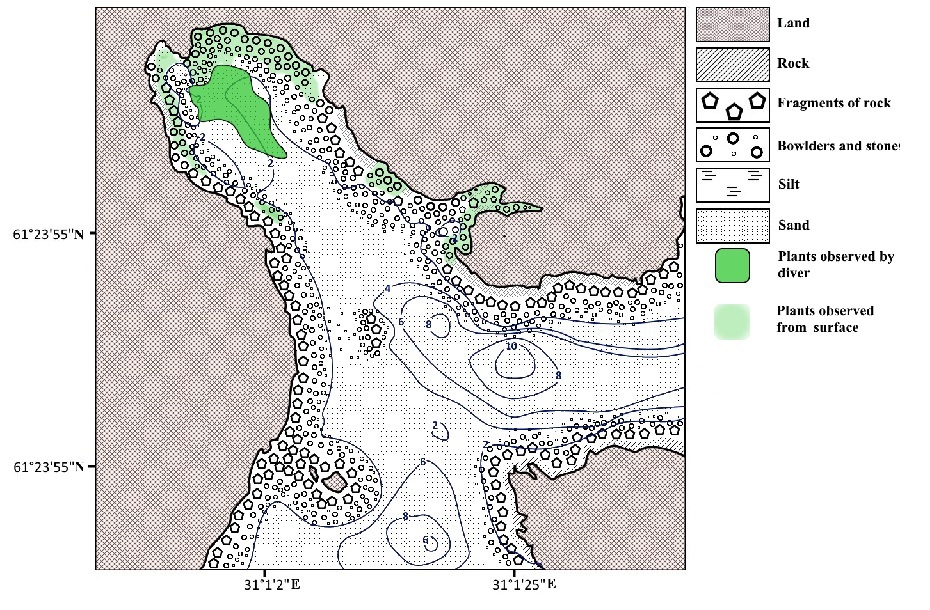
Fig. 1. Zolotaya bay scheme of relief and grounds
Krasnyy bay is located at south west part of Valaam island (fig. 2). Bay length is 140 m; maximum depth is 20 m. The coast is composed of rock fragments and large bowlders.
Surf zone (0–2,5 m) consists of monolithic rocks. Rock fragments are located at a greater depth (2,5–5 m), then they change to large bowlders.
Bowlders are main ground type at the depth more than 5 m, but there is rock yield (6–8 m) in central part of the bay. Clay yield occurs at the depth of 10–15 m along north and west coasts, other part of the bay at this depth is occupied by sand. There is no slope of the bottom from the depth 15–20 m; the composition is dominated by sand. Small bowlder yield occurs in central part of the bay, which rises above flat sand bottom to a height 0,5–1,0 m. Only sand has been noted from the isobath of 20 m.
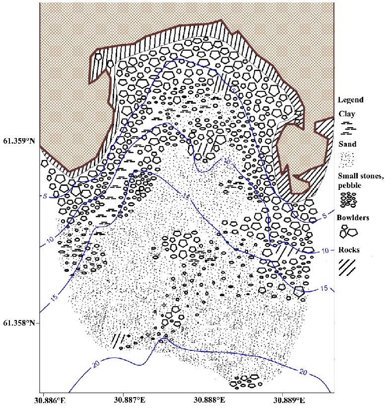
Fig. 2. Krasnyy bay scheme of relief and grounds
Krestovyy bay is located at south-western part of Valaam island. Bay length is 80 m, maximum depth is 20 m, its coast is steep and rocky.
Surf zone (0–1,5 m) consists of monolithic rocks. Rock fragments are located at a greater depth (1,5–3 m), then they change to bowlder slope with angle up to 90°. The slope finishes and proceeds to sandy bottom often with pebbles in all parts of the bay. Slope ending is located at the depth 5–6 m in inner part of the bay, and at the depth 9–10 m near the open part. Sand accumulates on the flat terrain. Generally, dependence of ground type on depth exists within Krestovyy bay.
Cape, which limits bay from the South-West (fig. 3), has underwater extension. The ness base is rocky; rock gradually changes to large bowlders. Blue clay yield which contains tightly packed large size pebbles has been noted near underwater cape base (fig. 3). Conglomeration of silt and plant detritus forms on the sand at the deepest points of bay.
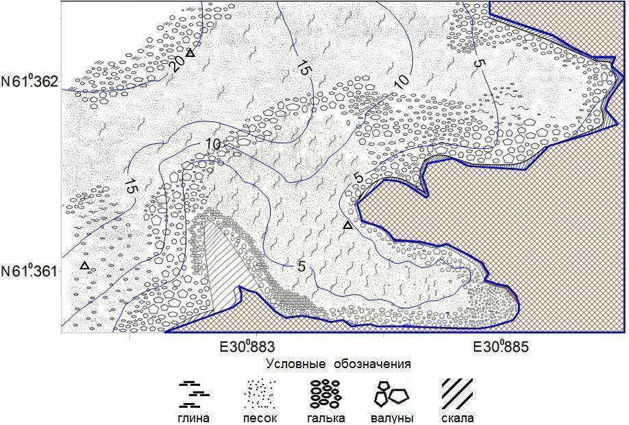
Fig. 3. Krestovyy bay scheme of relief and grounds
Malaya Nikonovskaya bay is located at north-western part of Valaam island (fig. 4). Bay length is 570 m; maximum depth is 24 m; it has various coastline landscapes. Rock ledges, bowlders of different size, sand, silty sand with stones and clay are found there.
Surf zone (at the depth 0–5 m) can be divided by ground and relief type into several regions. The inner part of the bay consists mainly of silty sand with rare inclusions of stones (fig. 4). Central coastal part of the bay is composed of rock and rock fragments and has significant slope, and the north part is composed of rocks and bowlders and partly proceeds to sand.
Mid-depth of Malaya Nikonovskaya (5–10 m) is occupied by brown silt. Silt zone width varies from 2 m in inner part of the bay to more than 100 m in the North part (fig. 4).
All central hollow is occupied by different types of silt. Silts of friable consistency, which surface reacts even to slight movement of water, occur at the depth of 10–20 m. Bottom surface at the deepest part of the bay (20–24 m) is covered by bacterial mat.
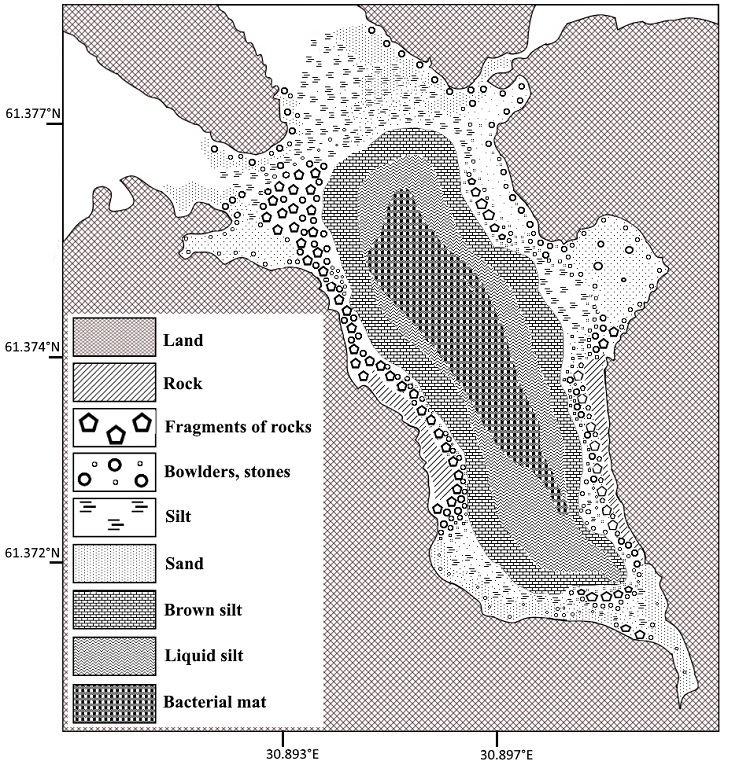
Fig. 4. Malaya Nikonovskaya bay scheme of relief and grounds.
- Discussion
Northern Lake Ladoga rocky littoral is the least investigated zone. Hydrobiological study in this zone is limited by depth to 1 meter. Exceptions are once-only studies. Some littoral areas had been described while macrophysics community had been being characterized by I.M. Raspopov [2, 3, 4, 5]. In the last year’s investigations of southern Lake Ladoga littoral are conducted by Limnology institute of Russian academy of science [6]. These coastal shallows descriptions are an important component of a wide range of research. Our group of underwater research laboratory RSHU has been investigating of coasts of Lake Ladoga since 2005.
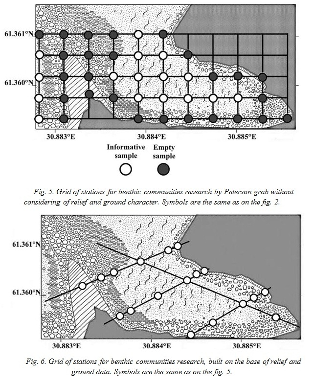
Description of the Krestovyy bay relief and ground changes allowed to optimize the study of benthic communities in the Bay [7, 8].
A grid of 42 stations (fig. 5) is required to describe benthic communities of different grounds with the same quality and without ground distribution data. Samples of macrozoobenthos would not be taken at more than half of stations (27) because of complex relief and hard ground. Only 18 stations, that is 2,5 times as less, were required to describe macrozoobenthos on all types of substratum using diving method of sample selection (fig.6).
It is important to base on knowledge of underwater part of coast slope for plant communities description. True aquatic plants are represented by Elodea canadensis, Potamogeton perfoliatus, P. alpines and Nitella sp. (fig.1). Plant communities predominantly develop at the depth of 1 m and fringe coasts in places where ground type allows them to grow. Zone of development of plants which is undetectable from surface has been found using diving method. Such hydrophytes as Elodea canadensis and Potamogeton perfoliatus have been met in inner part of the bay at the depth about 2 m.
Malaya Nikonovskaya bay is characterized by the greatest species diversity and variety of macrophytes among all studied bays. Using diving method lower border of macrophytes habitat area have been found out in this bay. Members of Elodea canadensis are met to a depth of 10 m, and some algae genus Nitella to a depth of 12 m. The obtained values exceed known littoral border in Ladoga lake (8,4 m). It should be noted, that water transparency (white disk visibility) ranged from 2,5 m to 4,5 m in summer 2013 year, from 2,7 to 4,4 in 2014 year, and from 2,4 to 4,9 in 2015 year in this bay. So depth of major plants habitat area border is more than 2 values of depth of maximum summer water transparency.
It is interesting to compare materials, which received using conventional method of field work describing lake plant cover and data of diving method (fig. 7). The major part of area occupied by hydrophytes has not been found, when water rakes and dredge has been used. Macrophytes have not been noted at all when working with the boat and from the shore in west coast of the bay. Nevertheless, underwater works have allowed finding significant macrophytes habitat area near this coast.
Thereby, data about macrophytes without binding to specific elements of relief are incomplete (fig. 7).
On the base of research the new depth spreading of macrophytes has been registered. Traditionally, littoral was described to the depth of 8,4 m. [5]. Macrophytes spreading have been noted to the depth of 10-12 m by us.
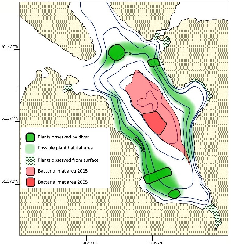
Fig. 7. Scheme of plant communities of Malaya Nikonovskaya bay and bacterial mat spreading from 2005 to 2015 years.
Bottom description of Malaya Nikonovskaya bay has been performed with the aim of assessment of trout farm located in the bay influence at bottom communities. The first description of bay bottom had been performed in 2005 year. Deposit, bacterial mat, presumably of bacterial origin) has been formed as a result of organic matter inflow on the bottom of the bay [9].
Continuous organic matter inflow into the bay caused increase of area, occupied by bacterial mat (fig. 7). Currently the deposit occupies third of third bay square. Excess organic matter inflow during more than 10 years led to sweeping changes. Indirect signs even on the shallow water confirm excess of organic substance in the bay.
Recommendations have been made for employees of the farm on the base of changes, occurring in the bay. Also scheme of assessment of cage farm influence on planktonic and bottom communities of Malaya Nikonovskaya bay has been designed.
- Conclusion
Coastal shallow waters research of Lake Ladoga is an urgent task. These investigations allow solving a wide range of scientific problems. On the basis of landscape surveys have been collected new data on the aquatic plant and benthic communities, bays and coves of North Ladoga. The research has laid the foundation for the assessment of the negative impact of human activities. The set of methods suitable for a wide range of researchers coastal and freshwater bodies of various latitudes has been developed. The developed complex of methods is suitable to coastal marine and freshwater bodies of various latitudes.
IV. Acknowledgment
We thank Oksana Vladimirova, Dr. Anastasiya Stepanova, Dr. Ekaterina Voiakina, Roman Oskardov, Alexandr Yasnov, Alena Timoshina, Sergey Goldin, Nikolai Popov, Aleksandr Babin, Sergey Nedoshivin, Denis Oleniov, who assisted us in the field sampling, sample treatment and many other aspects of studies. Anfisa Berezina responsive helped with the English language.
1. Golikov A.N., Skarlato O.A., 1965. Hydrobiological investigations in the Gulf Posiet using diving equipment (in russian)// Studies of fauna of the seas of the USSR, 3(9). 5-21 pp.
2. Raspopov I.M. About using of diving equipment in the study of higher aquatic vegetation of northern bays of Ladoga (in russian) // Petrozavodsk: Karelia Publishing House, 1962, p 241-244.
3. Raspopov I.M. Higher aquatic vegetation large lakes of the North-West of the USSR. Leningrad., 1985. 200 p.
4. Raspopov I. M., Adamec L., Husák Š., 2000. Long-term aspects of aquatic macrophytes in two bays of Lake Ladoga of different nutrient status. In: Peltonen A., Grönlund E., Viljanen M. (eds.), Proceedings of the Third International Lake Ladoga Symposium 1999. Publ. of Karelian Inst. № 129, University of Joensuu, Finland, pp. 148-151
5. Raspopov I.M. Specific and cenotic diversity higher aquatic and coastal aquatic plants in the littoral zone of Lake Ladoga // Littoral zone of Lake Ladoga. SPb., 2011. 52-64 pp.
6. Dudakova D.S., Rodionova N.V., Protopopova E.V., Kapustina L.L., Bardinskiy D.S. The composition and dynamics of aquatic bay of littoral of Petrokrepost of Lake Ladoga (in russian) // Proceedings of Karelian Research Centre of Russian Academy of Sciences. No 2. Ser. Environmental studies. 2015. 53-70 pp.
7. Zuyev Y.A., Zuyeva N.V. Experience of rocky littoral macrozoobenthos of lake Ladoga research (in russian) // Scientific notes of RSHU. Press: scientific-theoretical journal - 2013. - № 30. - 134-147 pp.
8. Zuyev Y., Zuyeva N., Lapenkov A.: Rocky littoral zone macrozoobenthos of Krestovyi bay (Lake Ladoga). 4th European Large Lakes Symposium - Ecosystem Services and Management in a Changing World Joensuu, Finland, 24-28 August 2015. P. 54
9. Zuyev Y.A., Zuyeva N.V. Experience of trout farm diving survey (in russian)// Pisciculture and fish-farming: scientific-practical journal. - 2013. - № 10. - 17-25 pp.