
BISAC NAT010000 Ecology
BISAC NAT045050 Ecosystems & Habitats / Coastal Regions & Shorelines
BISAC NAT025000 Ecosystems & Habitats / Oceans & Seas
BISAC NAT045030 Ecosystems & Habitats / Polar Regions
BISAC SCI081000 Earth Sciences / Hydrology
BISAC SCI092000 Global Warming & Climate Change
BISAC SCI020000 Life Sciences / Ecology
BISAC SCI039000 Life Sciences / Marine Biology
BISAC SOC053000 Regional Studies
BISAC TEC060000 Marine & Naval
The Estonian coast is geologically diverse and is characterized by its embayed nature with a variety of beach types experiencing land uplift ranging from 0,5 to 2,8 mm/year [5].
nature
Introduction
The Estonian coast is geologically diverse and is characterized by its embayed nature with a variety of beach types experiencing land uplift ranging from 0,5 to 2,8 mm/year [5]. This is due to its location at moderate latitudes in a transitional area between major geological structures (Fennoscandian Shield and East European Platform) and climatic (maritime and continental) regions.
The current study focuses on Osmussaar Island. Lying somewhat isolated at the entrance of the Gulf of Finland, Osmussaar (Odensholm in Swedish) is the 14th largest island in Estonia with an area of 4,7 km2. It is an approximately 1,5 km wide and 5 km long relict island of the Baltic Clint, overlain by a thin layer of Quaternary deposits, which emerged from the Baltic Sea about 3000 years ago as a result of postglacial rebound [1]. A 7 m high Ordovician limestone cliff is the most characteristic feature in the northern part of the island, whereas 2–3 m high accumulative gravel-pebble beach ridges cover the southern part of the island [3]. The main shore processes are erosion from the Osmussaar Cliff, which recedes approximately 9 cm/yr, longshore southward transport of gravel-pebble and accumulation of the material as beach ridges at the southern end of the island. Osmussaar as a whole is slowly migrating to the south-east [3]. The main objective of the research is to investigate the role of various hydrodynamic parameters on sediment transport in the near-shore sea bottom by conducting several field test with painted sediments on the southwestern cost of Osmussaar Island.
Data and methods
Field tests in several locations along Estonian coast have been carried out since the 1970s (Initiated by Dr Kaarel Orviku) to determine the origin of accumulative material in the beach ridges and the sediment flow directions. A study of painted sediments was carried out on the south-western coast of Osmussaar Island in the frame of the current study. The sea is very shallow (less than 5 m deep) due to the limestone bench up to 1 km from the shoreline on this side of the island. Further offshore, the depth increases rapidly. Particles with the diameters: 1–2,5 cm (yellow), 2,5–5 cm (red) and 5–10 cm (blue) were used. Painted sediments were accumulated in piles and placed in 0,5–4 m depths on limestone bench in September 2011. The locations were recorded with RTK-GPS. The study sites were revisited in November 2011 and the changes were registered. The hydrodynamic study is based on the measurements of waves and currents using the Recording Doppler Current Profiler (RDCP-600) at the Sundgrund Bank (approximately 1 km west to the study area) during the period September–November 2011. The instrument was installed at a depth of 10 m at Sundgrund [4].
Results and discussion
The study with painted sediments showed that the sediment piles were dispersed in depths from 2 to 4 m, but remained nearly unchanged in lower depths. Such results might be caused by a low sea level and a lack of strong storms during the study period. As the maximum depths of the sediment piles was 4 m and the edge of the limestone bench is located close to 5 m isobath one can assume that more or less active erosion takes place over the entirety of the limestone bench bordering the island from the west.
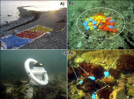
Figure 1 – A) A study of painted sediments was carried out.
B) Painted sediments were accumulated in piles and placed in 0,5–4 meter depths on
limestone bench. C) The hydrodynamic study is based on measurements of waves and
currents using Acoustic Doppler Profiler (on the picture) and the Recording Doppler
Current Profiler. D) The study with painted sediments showed that the sediment piles
were dispersed in depths of over 2 meters, only a few larger particles were found
between stones (Sediment pile on the picture is located in 3 meters depth)
Meteorological and hydrodynamic studies revealed that the mean wind speed during the strongest storm of the study period (with the painted sediments) reached 16 m/s. The measured maximum wave heights attained 3,4 m in the 11 m deep location. The sea-level remained close to the Kronstadt zero during the whole
study period. It can be concluded that low sea-level caused the waves to break and loose their energy in greater depths and the waves were too weak to move gravel and pebble closer to the shoreline.
Conclusions
The results of the field experiments with painted sediments showed that the waves of moderate storms in mean sea level conditions are capable to move sediment fractions with diameter of 1–10 cm nearer to the shore in over 2 meter deep basin. Accumulation of such fractions occurs in depth of approximately 2 meters, where swash is unable to shift the sediment further on. These deposits get onto the shore in case of strong storms in high sea level conditions. Further investigations with painted sediments and complex dataset of hydrodynamic, climatic and geomorphic characteristics are needed to determine the relationships between hydrodynamic parameters and coastal processes. This is an important scientific research task for the future, the results of which can contribute to sustainable coastal zone management and sustainable living conditions on the coast.
Acknowledgement
This work was supported by ESF Grants No. 9191, 8549, target financed project No SF0280009s07 and the EstKliima project of the European Regional Fund programme No. 3.2.0802.11-0043. Special thanks to Dean Adam Willis for his assistance in providing English language editorial comments and suggestions.
1. Kink, H. and Miidel, A. 1996. The Pakri Peninsula - Nature and Human Activity. Estonian Academy Publishers, pp. 94.
2. Orviku, K., 1992. Characterization and evolution of Estonian seashores. Tartu: Tartu University, Summary of doctoral thesis, 20p.
3. Suursaar, Ü., Szava-Kovats, R. and Tõnisson, H. 2011. Wave climate and coastal processes in the Osmussaar - Neugrund region, Baltic Sea. Benassai, G., Brebbia, C.A. and Rodriguez, G.R. (Eds.). Coastal processes II, WIT Press, 99-110.
4. Tõnisson, H., Suursaar, Ü. and Kont, A. 2012. Maps, aerial photographs, orthophotos and gps data as a source of information to determine shoreline changes, coastal geomorphic processes and their relation to hydrodynamic conditions on Osmussaar Island, the Baltic Sea. In: IEEE International Geoscience and Remote Sensing Symposium - Remote Sensing for a Dynamic Earth: July 22- 27, 2012, Munich, Germany, Proceedings: IEEE, 1-4.
5. Vallner, L., Sildvee, H. and Torim, A. 1988. Recent crustal movements in Estonia. Journal. Of Geodynamics, 215-223.