


BISAC NAT010000 Ecology
BISAC NAT045050 Ecosystems & Habitats / Coastal Regions & Shorelines
BISAC NAT025000 Ecosystems & Habitats / Oceans & Seas
BISAC NAT045030 Ecosystems & Habitats / Polar Regions
BISAC SCI081000 Earth Sciences / Hydrology
BISAC SCI092000 Global Warming & Climate Change
BISAC SCI020000 Life Sciences / Ecology
BISAC SCI039000 Life Sciences / Marine Biology
BISAC SOC053000 Regional Studies
BISAC TEC060000 Marine & Naval
The Vistula Spit is a sandy elongated barrier form which borders the Vistula Lagoon from the Baltic Sea. The evolution of the spit as well as nowadays sediment transport along the marine shore of it are still under discussion, especially due to existing of entrance jetties bordered the Strait of Baltiysk, the single inlet to the Vistula Lagoon, and advanced up to 10 m depth seaward. Different hypothesizes about ether uniform transport from north to south or contrary directed fluxes with convergence at various points at the spit shore are discussed. Most of them are based on fact of accumulation of sandy material just to north from the northern entrance jetty as in incoming corner. Basing on statistics of near-surface wind, direct measurements of currents and analysis of direction of the scour hole located between jetties the paper confirms the existence of two opposite fluxes - one brings alluvium from the Vistula River mouth to north as main winds blow from south-west and west, and, in contrast, another one brings material obtained by erosion of the western shore of the Sambian Peninsula to south. Dynamic equilibrium between these fluxes through hundreds of years resulted in formation of present shape of the coastline, and it is expected that the area of the equilibrium in alongshore migrations is in the top of the Yantarny- Baltiysk concave. Appearance of entrance jetties of the Vistula Lagoon inlet, in the area where opposite alongshore migration of material are nearly equalised, leaded to the accretion-erosion pattern, which is pseudo equal to sediment transport from north to south. In fact the accumulation of sand just to north from the northern entrance jetty and erosion to south from southern jetty may be explained by mechanism, when the sand transported in the incoming corner just near the northern mole by southward migrations is excluded from migratory movement and deposited in the zone shadowed by jetties (from northward migrations). Erosion to south of jetties is explained by wind surges in incoming corner for prevailing western winds.
sediment transport, Vistula Spit, Baltic Sea, current measurements.
- INTRODUCTION.
The study area covers the southern and eastern shores of the Gulf of Gdansk, from the mouth of the Vistula River to the Taran Cape (Fig. 1). Here, most intensive sediment alongshore transport occurs, which has been the subject of research in the last century (all references to studies are given below). The single inlet of the Vistula Lagoon, further called the Strait of Baltiysk (the ‘Baltiysk Strait” in some studies), is bordered by jetties stretched seaward up to 10 m depth.
The eastern shore of the Gulf of Gdansk has a concave form, the Sambia-Vistula arc, with the shoreline orientation changing from the west-eastern direction (the shore near the mouth of the Vistula River) to the south-north (the shore of the Sambian Peninsula). Thus, the prevailing
winds of the western rhumbs [1-4] influence the shore at an acute angle near the mouth of the Vistula River, and on the Sambian Peninsula shore, almost normal to the shore. This creates prerequisites for a change in the sediment transport direction within the Sambia-Vistula arc.
The purpose of this work is to provide an analysis of the prevailing wind direction and the results of the direct measurements of currents in the Strait of Baltiysk area and on that basis conjecture about the direction of sediment transport on the eastern shore of the Gulf of Gdansk distinct from previous hypotheses derived by evaluating the wave energy transport and the accumulative morphodynamic criterion.
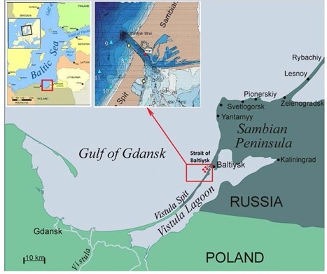
Fig.1. Location of the study area in the South-Eastern Baltic.
The researchers focussing on the phenomenon could not come to a consensus about the outcome of sediment transport along the eastern shore of the Gulf of Gdansk. First Tornquist (1910) [5] and Brükmann (1913) [6] believed that the sediment transport from the south to the north, up to the Taran Cape prevails, while Tidemann (1930) [7] and Pratje (1932) [8] claimed the outcome sediment transport from Yantarny to Baltiysk, but none of them have extended it further to the south.
In Russian literature sources the idea dominant by the end of the last century was that of the unidirectional transfer of sediments to the south of the Taran Cape to the mouth of the Vistula River (Fig. 2а). The idea followers headed by R. Knaps and V.P. Zenkovich were justifying their point of view by changes in the shore morphology [9-14], an increase in the number of underwater bars as soon as sediment flows become saturated [15] and the main argument was the accretion at the northern jetty of the Starit of Baltiysk and the downstream erosion immediately south the southern jetty [13, 14] (Fig. 3b).
As soon as the field and laboratory test data were compiled, the local flows concept was elaborated, which included the idea of the migrations oppositely directed within the limits of a lythodynamic cell [16-19]. The existing schemes of the outcome longshore sediment transport, the availability and location of the transport direction change area can be divided into three groups. According to the current concepts in the literature, the mark (or convergence) change zone of the resulting sediment transport within the Gulf of Gdansk can be at the top of the Baltiysk-Yantarny shore concavity (Fig. 2b, [20]), in the vicinity of the Vistula Lagoon inlet, which is designed with entrance breakwalls that go into the sea to the depths of 10 m (Fig. 2c, [10, 15]), or within the Vistula Spit (Fig. 2d-f, [17, 19, 21, 22]).
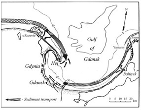
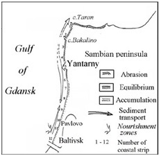
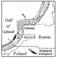
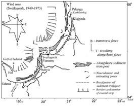
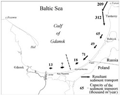
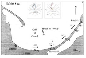
Fig. 2. Different visions on sediment transport structure along the eastern shore of the Gulf of Gdansk: (a) unidirectional flux to south [12] (1958); (b) convergence of fluxes at the Yantarny- Baltiysk concave [20] (1984), or (c) around the Vistula lagoon inlet [10] (1982), or (d) in the central part [17] (2003) or (e,f) at the southern part of the Vistula Spit, [21] (2010) and [22] (2012).
- SCOUR HOLE IN THE VISTULA LAGOON INLET
The scour holes [13] are a typical morphometric manifestation of the excited longshore currents an obstacle in the sea. The existing drainage line at the breakwaters of the Vistula Lagoon inlet stretched out from the southern breakwater to the northern one can show that there are the prevailing currents and intense transit of sediment from SW to NE.
The scour hole has the elliptical shape, and is adjacent to the head of the southern breakwater and crosses the fairway in the NW direction, roughly parallel to the shore. It began to take shape after the construction of the existing jetties (1878) and as early as 1903 it had distinct contours with depths up to 11-14 m (Fig. 3а). At the beginning of the twenty-first century, the maximum depth of the scour hole reached 28.5 m (Fig. 3b), and increased up to 32 m after reconstruction of the breakwater extremities in 2006-2008 and moved closer to the southern breakwater. At that, the depths in the fairway remained 10-12 m.
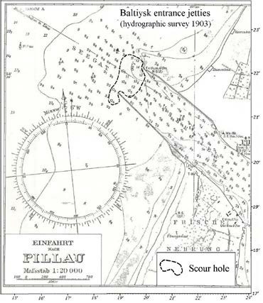
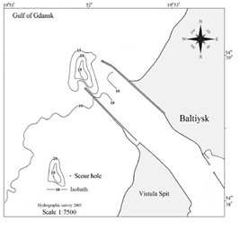
Fig. 3. Scour hole at the seaward end of the jetties of the Vistula lagoon inlet on the map of 1903 (a) and in 2005 (b), the accretion to north and the erosion to south are clear visible (b).
- WIND AND WAVES IN THE STUDY AREA
According to the weather station in Baltiysk (Fig. 1), the long-term average annual frequency of occurrence of all winds of the SW-W-NW directions is approximately the same (14.68% - 14.95% -14.31%), and only from the N rhumb it is a little less (10.45%). The share of W-SW rhumbs increases for stronger winds; and it significantly decreases from the N side. Such a redistribution of the repeatability of directions for wave-hazardous winds (W>6m/s) is due to seasonal restructuring of the western transfer of air masses, which is manifested in the activation of the winds from the south-western quarter of the horizon in the autumn-winter storm period. For storms (Table 1, W≥14m/s) W wind repeatability (56.4%) exceeds the total repeatability of the other 3 directions (43.6%), respectively, the frequency of the impact of the SW-W storm winds is 72.9%, while the repeatability of the NW-N directions is only 27.1%, and the repeatability of the N wind is very low 3.9%. So, the winds of the W rhumb significantly prevail in the wind direction structure for storm situations.
The resulting azimuth for SW-N winds with the speed more than 6 m/s and more than 14m/s is equal to 276°. The resulting azimuth of SW-N waves with a height of h ≥ 1 m is 290°, h ≥ 2 m – 284°, h ≥ 3 m – 287°.
Due to the orientation of the stretch of the sea shore of the Vistula Spit (azimuth normal to the shore in the Baltiysk area is 300°) the long-term average annual wind pattern in the South- Eastern Baltic (according to data collected in Baltiysk) should favour the predominant sediment transport from SW to NE, i.e. along the spit in the direction of the Baltiysk-Yantarny shore concavity. This tendency is especially obvious for storm winds, during which there are basic motions of sediment. This situation is also typical for the wave repeatability (Table 2), consequently, it is expected that the longshore component of the wave energy flux is directed in the northern half of the horizon here.
Table 1. Wind frequencies and intensities in wave-hazardous directions (in % of all possible wind directions) for fresh and storm wind speed gradations according to the Baltiysk weather station data for 1949-1988 [1]
|
Compass point |
N |
NW |
W |
SW |
Σ |
|
Gradation, m/s |
|
|
|
|
|
|
6 - 9 |
2.54 |
5.55 |
6.38 |
7.19 |
21.66 |
|
10-13 |
0.22 |
1.06 |
2.76 |
1.38 |
5.42 |
|
14-17 |
0.06 |
0.30 |
0.74 |
0.24 |
1.34 |
|
18-20 |
0.01 |
0.11 |
0.26 |
0.06 |
0.44 |
|
21-24 |
|
0.01 |
0.01 |
|
0.02 |
|
25-28 |
|
|
0.01 |
|
0.01 |
|
Σ (6-28 m/s) |
2.83 (9.80)* |
7.03 (24.33) |
10.16 (35.17) |
8.87 (30.70) |
28.89 (100) |
|
Σ (14-28 m/s) |
0.007 (3.87) |
0.42 (23.20) |
1.02 (56.35) |
0.30 (16.57) |
1.81 (100) |
* Note. In parentheses the repeatability only for this gradation within the whole wave- hazardous direction sector (N-SW) is indicated.
Table 2 Repeatability (%) of waves in deep water (Н=10 m) according to the Baltiysk weather station data for 1975-1984 [23]
|
Wave height, h m |
N |
NW |
W |
SW |
∑(N- SW) |
|
h ≥ 0 m |
26.61 |
15.65 |
28.42 |
15.17 |
85.85% |
|
h ≥ 1 m |
9.85 |
9.31 |
19.53 |
7.95 |
46.83% |
|
h ≥ 2 m |
1.39 |
2.26 |
7.41 |
1.12 |
12.19% |
|
h ≥ 3 m |
0.27 |
0.2 |
1.13 |
0.11 |
1.73% |
IV. CURRENTS NEAR THE EASTERN SHORE OF THE GULF OF GDANSK
The instrumental measurements of near-bottom currents were made by the Atlantic Branch of the Institute of Oceanology of Russian Academy of Sciences at 4 points to the south entrance jetty of the Strait of Baltiysk in the period 12.09-18.11.2005. Mechanical current meters BPV-2 (the sampling frequency is once per hour) were installed at the depth of 12 m (point 9,
 12.09 - 10.11.2005, and point 11, 12.09 - 18.11.2005) and at the depth 6 m (point 8, 12.09 –
18.09; 09.10-18.11.2005, and point 10, 12-16.09.2005).
The measurements period was dominated by the wind from the southern half of the horizon (WSW-S-ESE, 69.7%) and only in 17.8% it acted from the northern half (WNW-N-ENE). The E-W wind direction was recorded in 12.5 % cases. The wind speed did not exceed 8-10 m/s, and in only 4 instances (15.09, 24.10, 27.10 and 15.11) a short increase of wind up to 13, 15, 17 and
14 m/s was recorded [24]. Fig. 4 presents a current rose [18] at the measurement points (indicating the number of samples) constructed for situations with the wind speed of 8 m/s or more (for 6 gradations of wind direction - N, NW, W, SW, S, SE, that were recorded during the measurements for quite a long time). Measurement points were chosen in order to determine the area of influence of jetties [18].
For the oblique onshore winds (N, W directions), bottom currents were oriented in the direction of the longshore component of the wind action with a small deviation in the direction of the sea or shore depending on the water level variations (Fig. 4 a,c). During the period of exposure to the onshore wind normally to the shore (NW) the currents at deeper stations (9 and 11, the depths of 12-15 meters) have a substantial component along the shore to the north, and on the shallower stations (8 and 12), on the contrary, along the shore in a southern direction (Fig. 4b). With the longshore wind from SW the near-bottom velocities are directed along the shore northwards (Fig. 4d). For the winds of coastal rhumbs (SE and SE), the current velocities were mainly directed to the north (Fig. 4e,f).
а) 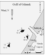 b)
b) 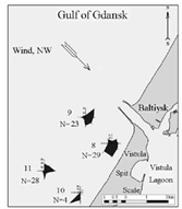 c)
c) 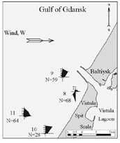 d)
d) 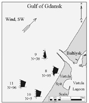
е) 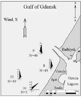 f)
f) 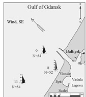
Fig. 4. Roses for coastal currents for the period 12.09.2015-18.11.2005 combined for typical wind directions: (a) N, (b) NW, (c) W, (d) SW, (e) S, (f) SE.
The maximum recorded velocities of the near-bottom currents at stations 8 and 10 reached 45 and 54 cm/s, at deep-water stations 9 and 11, 34 and 44 cm/s respectively.
In general, the measurements fully confirmed the physical pattern, the near-bottom currents are directed towards the longshore component of the wind and wave action starting with the wind velocities 6-7 m/s [17, 24]. This is manifested in all wind directions (N, NW, W, SW, S), with the longshore wind and oblique onshore winds a one-way flux of near-bottom waters directed along the wind is generated.
- DISCUSSION
The foregoing presentation and results indicate a discrepancy between the fact that based on the prevailing direction of strong winds (from west to east), the longshore sediment transport within the Sambian-Vistula lithodynamic system should be directed to the north, and the model estimates of the wave energy direction [21, 22] and geomorphological accretion criteria [13, 14] indicate its southern direction.
The calculations of the wave energy pattern in [21, 22] were based on wind statistics and leaded to the conclusion that the area where longshore transport changes the direction (convergence zone) is located at the root of the Vistula Spit. In [21, 22] the geostrophic wind data were used, while direct measurements lead to other statistics [1, 25] (see sub-section 3). This difference in the statistical distribution of the geostrophic and near-surface winds (the latter acts in the Ekman friction layer) is quite natural. So, the calculations [21, 22] contained the uncertainty in the original data influencing the results.
Models [22] showed that the area where longshore transport changes the direction is in the coastal segment, where the direction of the normal to the shore coincides with the azimuth of the resulting wind action (Fig. 2e,f). Based on this dependence, we can say that taking into account the near-surface wind statistics [1, 25] (see sub-section 3), you should expect the change of alongshore sediment transport within the Baltiysk-Yantarny concavity.
It is essential to note that for any transverse profile two integral opposite longshore flows are shown in [21], i.e. during a long-term period the integrated sediment flow vector is directed north and south depending on the wind situation, and there is a zone to change the mark of the longshore transport, where these flows are equalised. This means, first of all, that there is constantly a significant longshore sediment migration rather than a one-way transfer along the shore of the Vistula Spit. And, secondly, that there are no two converged flows in a one moment in the zone, characterised by the change of alongshore transport direction, this zone may even be called a convergence zone. Thirdly, as the resulted long-term sediment fluxes are directed towards each other from both sides of this zone, the sediment accumulation is expected in this zone. Once, the cross-shore seaward transport of sediments increases along the decrease of alongshore transport, and material deposited on a beach is involved in eolian transport, the flattening of the bottom slope (a), the widening of the beach (b) and the growth of the foredune height (c) are expected in this zone.
Supporters of the idea that the longshore flow is directed from Baltiysk to the south argue their position on the basis of the accumulative morphodynamic criterion: there is the accretion of sediment at the incoming corner (for a sediment flow) before the obstacle set perpendicular to the shore, and abrasion behind the obstacle [13, 14]. As it is traditionally assumed [14] that on the Baltic Sea shore the sediment flow is maintained by alongshore currents, then according to the accretion on the north side of the jetties of the Strait of Baltiysk and abrasion, on the south, the stream of sediments of the subject criterion is directed from north to south. Although, a shown in Section 3, there are no conditions that determine the prevalence of flows to the south on average per year.
On the shores with predominantly one-way sediment transport such a criterion does point to the direction of the resulting sediment transport. However, it is impossible to make a clear conclusion from the application of the only criterion because according to [26], the current and waves are in different ways involved in the deformation of the shores and bottom near the cross- shore breakwater, a sediment transport caused by the mean water flow (forced by the wind or water level gradient) gives the filling of the incoming corner by sand, and the sediment transport supported by the wind-induced waves lead to surges and erosion in the entrance angle and sediment deposition behind the breakwater.
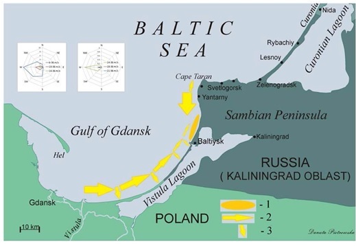
Fig. 5. Principle scheme of sediment transport on the eastern shore of the Gulf of Gdansk:
1 – alongshore resulted sediment transport; 2 – offload and supply of sediments to alongshore transpo, 3 – area of equilibrium of alongshore sediment migrations
Based on the immutability of the near-surface wind statistics (Section 3) and principle result of [22], that alongshore flux changes the direction at the shore segment having normal windward, we can assume that before the appearance of breakwaters in the XIX century the entire shore from the mouth of the Vistula River to the present location of Yantarny village was the scene of active migration of the sand material with a zone of change of sediment transport direction in the area of the top of the Yantarny-Baltiysk concavity. This view means that the Vistula Spit was built mainly by the Vistula alluvium (by the part of the flow through the Nogat arm from the Vistula Lagoon, and from the sea by the longshore movement of sediment from the mouth of the Vistula) and only a portion of abrasion material of the western shore of the Sambian Peninsula.
After the appearance of jetties of the Strait of Baltiysk and their extension to a depth of 10 meters, the accretion of material north of jetties and active erosion south of them along with the wind statistics (Section 3) fits into the concept that sediments at the winds in the southern direction fill the incoming corner of the northern jetty and are excluded from migratory movements, as during the winds from west and south this accumulated area is located in a wave shady of the jetties.
The erosion from the upwind side is typical for a long jetty, which have the incoming corner quite extensive and is oriented towards the prevailing storm winds. The resulting surge in the corner justifies an active bottom outflow of water (with sediments) depending on the prevailing wind, either along the shore to the south, or along the southern jetty to its seaward end.
The stability of the location and orientation of the scour hole is another argument in favour of the conclusion about the resulting transport of sediment from the upwind jetty to the downwind jetty, from south to north, towards the Baltiysk-Yantarny concavity.
- ACKNOWLEDGEMENT
Authors thank colleagues from the Department of Coastal Engineering and Dynamics of the Institute of Hydroengineering of the Polish Academy of Sciences for providing the data for wave measurements for calibration of the model. Research and preparation of this article were supported by the Russian Science Foundation: the study of the dumping sites at the Vistula Spit, Ц by the Project No 14-17-00547, and the modelling of sediments transport near the dumping site on the northern shore of the Sambian Peninsula Ц by the Project No. 14-37-00047.
1. Scheme of the Landslide and Shore Protection Actions on the Baltic Shore within the Kaliningrad Region, Volume 1, Book 1. Natural and Hydrometeorological Conditions of the Kaliningrad Shore of the Baltic Sea. Svetlogorsk, 1999. 130 p.
2. V.A. Chechko, B.V. Chubarenko, V.L. Boldyrev, V.P. Bobykina, V.Yu. Kurchenko, D.A. Domnin, “On the Sea Coastal Zone Dynamics in the Area of Protective Breakwaters of the Kaliningrad Sea Channel”, Water Resources, Moscow. vol. 35, no 6, pp. 681-691, 2008.
3. V. Chechko, A. Sokolov, B. Chubarenko, D. Dikii, V. Topchaya, “Dynamics of sediments disposed in the marine coastal zone near the Vistula Lagoon inlet, south-eastern part of the Baltic Sea”, Baltica., vol. 28 (2), pp. 189-199, 2015.
4. B.V. Chubarenko, S.E. Navrotskaya, Zn.I. Stont, O.A. Gushin, "Variability of the Hydrometeorological Characteristics near the Shore of the South-Eastern Baltic Observations 1996-2009” in The Basic Concepts of Modern Coast Use, vol. IV, L.N. Karlin, M.B. Shilin and P.F. Brovko Eds. Saint-Petersburg: Russian State Hydrometeorological University, 2012, pp. 247 - 269.
5. A. Tornquist, Geologie von Ostpreussen, Berlin, 1910.
6. R. Brükmann, “Beodachtungen über Strand verschiebungen an der Küste des Samlands. ІІІ. Palmnicken”, Schrift. Phys. ökonom. Ges. Jahrgang, Leipzig und Berlin, vol. LIV, pp. 119-144, 1913.
7. B. Tidemann. Uber Wandern des Sandes Kiistenraum des Samlandes.- Zeitschr. Bauwesen: 1930, pp. 199-212.
8. O. Pratje Der Verbleib des Abbruchsmaterials der Samlandkuste. Schr. d. phys. okon. Ges. Konigsberg: 1932, pp. 5-50.
9. V.R. Boynagryan, “Dynamics and Morphology of the Sambia Peninsula”, Oceanology, Moscow, vol. VI. Issue 3, pp. 458-465, 1966.
10. V.L. Boldyrev, V.P. Zenkovich, “The Baltic Sea”, in The Far East and the Shores of the Seas Surrounding the Territory of the USSR. Moscow: Science, 1982. pp. 214-218.
11. V.L. Boldyrev, O.I. Ryabkova, “The Dynamics of Coastal Processes on the Kaliningrad Shore of the Baltic Sea”, Proceedings of the All-Union Geographical Society, Moscow, vol. 133, Issue 5, pp. 41-49, 2001.
12. V.P. Zenkovich, “Some Features of the Polish Shore Dynamics of the Baltic Sea”, Transacts of the USSR Geographical Society, Moscow, vol. 90, Issue 3, pp. 23-31, 1958.
13. R.Ya. Knaps, “Protecting Structures such as Breakwaters and the Sediment Movement on Sandy Shores”, Newsletter of the Latvian SSR Academy of Sciences, Riga, No 6 (59). pp. 87-130, 1952.
14. R.Ya. Knaps, “Movement of Sediments near the Eastern Baltic Shore”, in Development under Oscillatory Movements of the Earth’s Crust. Tallinn: Valgurs, 1966. pp. 21-29.
15. V.L. Boldyrev, “Underwater Sand Bars as Indicators of the Longshore Sediment Transport” Scientific Proceedings of the Institute of Oceanology of the USSR Academy of Sciences. Moscow, vol. XLVIII. pp.193-201, 1961.
16. A.P. Agapov, L.A. Zhindarev, “Particle Size Distribution of Beach Sediments as an Indicator of the Sediment Movement Mechanism of in the South-Eastern Baltic Coastal Zone”, Lithology and Mineral Resources, Moscow, No 6. pp. 105-111, 1990.
17. A.N. Babakov, Spatio-Temporal Structure of Currents and Sediment Transport in the Coastal Zone of the South-Eastern Baltic Region (Sambia Peninsula and Curonian Spit). Thesis of PhD in Geographical Sciences, Kaliningrad: Faculty of Geography of the Kaliningrad State University, 2003.
18. A.N. Babakov, “Wind-driven currents and their impact on the morfolithology at the eastern shore of the Gulf of Gdansk”, Archives of hydro-engineering and environmental mechanics, Gdansk: Institute of Hydro-Engineering of Polish Academy of Sciences, vol. 57. no. 2. pp. 85 -104. June 2010.
19. N.A. Bogdanov, V.A. Sovershaev, L.A. Zhindarev, A.P. Agapov, “The Evolution of Ideas about the Dynamics of the South-Eastern Shores of the Baltic Sea”, Geomorphology. no 2. pp. 62-69. 1989.
20. A.V. Beloshapkov, .G. Beloshapkova, G.Kh. Brasavs, “Features of the Sediment Dynamics on the Western Coast of the Sambia Peninsula”, in The Structure of the USSR Sea Shelf as a Basis for the Evaluation of Engineering and Geological Conditions. Collection of Research Papers of the All-Soviet Union Research Institute Morgeo, Riga. 1984, pp. 42-45.
21. R. Ostrowski, Z. Pruszak, M. Skaja & M. Szmytkiewicz, “Variability of hydrodynamic and lithodynamic coastal processes in the east part of the gulf of Gdansk”, Archives of Hydro- Engineering & Environmental Mechanics, Gdansk: Institute of Hydro-Engineering of Polish Academy of Sciences, vol. 57 (2), pp. 139-153, 2010.
22. I.O. Leontiev, “Projection of the Shore Development in the Century Scale (by the example of the Vistula Spit)”, Oceanology, Moscow, vol. 52. no 5. pp. 757-767, 2012.
23. O.I. Ryabkova, The Dynamics of the Shore of the Sambia Peninsula and the Curonian Spit in the context of the Coastal Protection Problems. Thesis of PhD in Geographical Sciences, Moscow: Faculty of Geography of the Moscow State University, 1987.
24. A.N. Babakov, “Characteristics of Near-Bottom Currents of the Gulf of Gdansk near the Entrance Breakwaters of the Port of Baltiysk According to Field Measurements’, Scientific Notes of the Russian Geographical Society (Kaliningrad Region), vol. 7, part 1. Kaliningrad, 2008. pp. G1- G6.4.
25. Hydrometeorological Conditions of the Vistula Lagoon, N.N. Lazarenko and A. Maevsky Eds. Leningrad: Gidrometeoizdat, 1971, 330 p.
26. Guidelines for Research and Calculation Methods and Sediment Movement and Coastal Dynamics in Engineering Surveying. Moscow: Gidrometeoizdat, 1975. 240 p.