


BISAC NAT010000 Ecology
BISAC NAT045050 Ecosystems & Habitats / Coastal Regions & Shorelines
BISAC NAT025000 Ecosystems & Habitats / Oceans & Seas
BISAC NAT045030 Ecosystems & Habitats / Polar Regions
BISAC SCI081000 Earth Sciences / Hydrology
BISAC SCI092000 Global Warming & Climate Change
BISAC SCI020000 Life Sciences / Ecology
BISAC SCI039000 Life Sciences / Marine Biology
BISAC SOC053000 Regional Studies
BISAC TEC060000 Marine & Naval
The Azov Sea Coast is subjected to a complex of hazardous exogenous geological processes, landslides and abrasion being the most important ones. Both natural and anthropogenic factors contribute to the development and intensification of these processes. These processes are currently growing due to an increased frequency of storm surges.
geomorphology of coastline, beach forming material, gullies and ravines network, regulation of river flow, cyclonic activity, shores abrasion, hazardous exogenous geological processes, satellite monitoring.
The Azov Sea Coast is subjected to a complex of hazardous exogenous geological processes, landslides and abrasion being the most significant ones. The development and activity of these processes are intensified by both natural and anthropogenic factors. Climate change that results in increasing cyclonic activity, an increased frequency of western storms and surges, sea-level rise should be referred to natural factors [1]. Adverse environmental conditions (widespread easily-washed clay deposits in the coastal cliffs, low sand power, the shortage of beach forming material), multidirectional nature of neo-tectonic processes in the coastal zone, extensive gullies and ravine network also contribute to the active growth of the processes.
The main man-made effects include the intensive use of the coast by a number of different farmers, who often do not take into account the natural characteristics of the coastal zone (e.g. intensive plowing, deforestation, agriculture irrigation, river flow regulation leading to reduction of beach forming material, an unauthorized removal of sand and shell material from the beaches and spits, the change of sediment balance, deterioration of water quality and the reduction of biological components in the beach construction).
The Azov Sea Coast has been observed for more than 60 years [2-6]. Scientific monitoring is carried out by a reference network within the Russian coasts of the Don, Kuban areas, the Crimea involving 70 major districts. The total length of the studied coastline is over 1,000 km.
A number of observations available have revealed the cycles of intensification and stabilization of abrasion-landslide processes (Fig. 1). Periods of 1980-2002 and 2006-2010 are characterized by the abrasion stabilization, with the average speed at that time not exceeding 1 m/year, while the 2003-2006 and 2010-2014 periods are characterized by an intensification of these processes that is associated with an increased frequency of storm surges from the western part.
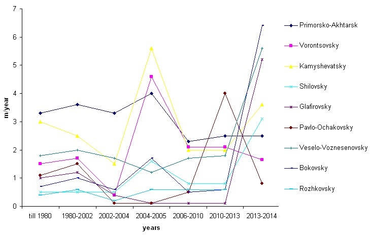
Fig. 1. Abrasion speed dynamics on the Azov Sea Coast
Particularly high rates of the coast destruction were recorded in 2013-2014, that was due to an increased frequency of winds and surges and catastrophic level rise, a notable example of which is the surge that took place on 24, September 2014.
The wind surges caused an increase of water level on the whole eastern coast of the Azov Sea, the Taganrog Bay and at the mouth of the Don River. Most hydrological stations recorded extremely high figures. This surge phenomenon is historically maximum ever recorded from the 1881 – 2014-period- observations.
The storm led to intensive coastal erosion in Primorsko-Akhtarsk, Veselo-Voznesenovsky, Glafirovsky and Shilovsky areas, and to flooding and erosion of the beaches in Dolzhansky, Yeisk, Chumburskaya, Pavlo-Ochakovo spits (Fig. 2). In the period of 2010-2013 abrasion rate reached 1.8 m/year, and in 2013-2014 it was 3.1m/year.
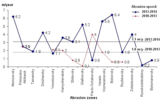
Fig.2. The abrasion rate in the Azov Sea emergency areas in 2013-2014
The coast of the Azov Sea has been zoned into the areas with mild, moderate, severe and very severe abrasion by abrasion processes activity (Fig. 3).
In the modern period (2013-2014) there were 20% of the shores with a weak abrasion (up to 1 m/year). Such abrasion rate was recorded in the areas near Russkaya Sloboda village (0.2 m/year), Pavlo-Ochakovo village (0.8 m/year), Botsmanovo village (0.8 m/year).
The average speed of coastal retreat (1-2 m/year) i.e. 20% of abraded coast has been recorded in such areas as: Vorontsovsky (1.7 m/year), Rozhkovsky (1.8 m/year), Taman (1.9 m/year).
Strongly abraded coast (2-4 m/year) i.e. 27% has been found in the areas of Primorsko-Akhtarsk (2.5 m/year), Shilovsky (3.1 m/year), Kamyshevatsky (3.6 m/year), Zolotokosovsky (4 m/year).
Such settlements as Dolzhansky (4.2 m/year), Glafirovsky (5.2 m/year), Veselo-Voznesenovsky (5.6 m/year), Morozov (6.2 m/year), Bokovsky (6.4 m/year) have been specified as emergency areas (at a rate of 4 m/year) that is 33% if activity of hazardous processes with a very strong abrasion is taken into account (Fig. 3).
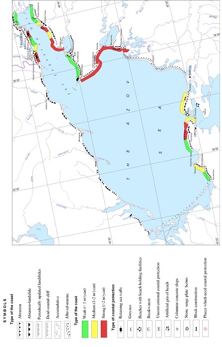
Fig. 3. Zoning of the Azov Sea coast by the abrasion processes degree
It has been found that the percentage of beaches with strong and very strong abrasion increased from 33% in 2010-2012 to 60% in 2013-2014., i.e. almost twice as much.
The Kerch peninsula is dominated by an abrasion and abrasion-accumulative shore, the beach from Cape Zyuk to the Kerch Strait is the most dangerous, which retreats on average 1.6 m/year, and from the eastern side of the Kazantip Gulf to Cape Zyuk - 1.1 m/year.
The shores in such villages as Nasir, Zavodskoe, Kurortnoe, Yakovenkova, Chelyadinov, and settlements as Podmayachny, Geroevskoe can be considered to be the emergency areas of the Kerch peninsula in terms of abrasion-landslide processes.
Nowadays the Kerch Peninsula coastal zone is in extremely poor condition. The coast tends to retreat; it is caused by specific geological and geomorphologic composition and hydrodynamic processes, as well as anthropogenic factors (hydraulic structures in the coastal zone, construction sites on the beaches and coastal dunes, coastal protection made of concrete material, sand and gravel picking from the beaches,).
Evaluation of spatial development of abrasion processes, the amount of material has shown that the variability of these indicators is due mainly to lithological characteristics of rocks (widespread distribution of unconsolidated sedimentary rocks, loess loam and clay) and the occurrence of surges.
Accumulative forms of the Azov Sea are also subjected to considerable deformations. The study is regularly carried out both at reference points, and with remote sensing of the Earth. Comparing the data from the map in 1980 and satellite images for a number of the Azov Sea forelands has shown that the area of the spit during this period did not change. But their displacement is noticeable in the eastern direction.
The western shore is eroded, and the material is redeposited on the eastern coast (Fig. 4). As for Dolzhanskaya Spit (foreland), on the contrary, the eastern shore is eroded, the accumulation of sediment occurs on the western one. The erosion speeds in different parts of the coast vary from 1 to 3 m/year [9-10].
Extreme surges which occurred in March 2013 and in September 2014 seriously affected the accumulative forms of the Azov Sea Spits (forelands): Dolzhanskay, Chumburskya, Pavlo-Ochakovsky, Petrushinskoe. Most of the forelands were flooded, the water level rose to the level of more than 2 m, which led to some catastrophic damage.
Particularly the main buildings, the recreation center, guest houses were badly damaged which are located next to the spit, near the spit base and in close proximity to the original bank.
Constant monitoring of the coastal area, the development and implementation of complex coastal protection and environmental management measures are necessary to preserve the coast infrastructure, cultural and architectural monuments of highways and other facilities.
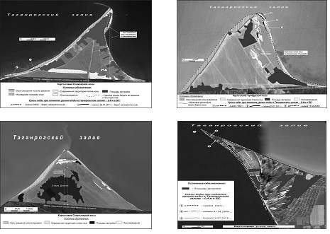
Fig.4. The spit displacement of the Taganrog Bay in 1982-2012
Long-term studies have shown that the Azov Sea coast is badly eroded as a result of dangerous exogenous processes, the most contributing of which are landslides and abrasion. A number of observations available have revealed their activation and stabilization cycles. In the modern period intensification of abrasion-landslide activity is observed, namely, the share of the shores with strong and very strong abrasion increased from 33% in 2010-2012 to 60% in 2013-2014., i.e. being almost twice as much.
An examination of bank protection structures of the Azov Sea coast has revealed that they are in a very poor condition. To date, they have been severely deformed or destroyed, as heavy concrete structures are mainly used on the loamy Azov coast. Rockfill groynes, suppressing surges dams made of natural stone, gravel and pebble beaches have proved to be a positively effecient way of coastal protection.
Research was done within the theme "Development of assessment methods and technology and natural hazards forecasting in Azov region of the Don, Kuban areas, the Crimea" (Southern Federal University grant № 213.01-07-2014/14PCHVG).
1. L.A Bespalova., P.M Lurie., A.E Tsygankova., T.A Vetkina., O.Sh Nosikova “Level mode Taganrog Bay in the modern period” //Modern technology monitoring and development of natural resources of the southern seas. International seminar proceedings. (Rostov-on-Don, 15-17 June 2005) -Rostov-on-Don, «TsVVR», 2005. - pp. 27-29
2. V.P. Zenkevich “The shores of the Black and Azov Seas”. - Moscow: Geographgis, 1958. - p. 373.
3. V.A. Mamyrkina, Yu.P. Khrustalev “The coast of the Azov Sea” - Rostov-on-Don: RSU Press, 1980. - p. 176.
4. Yu.V. Artyukhin “Wave destruction of the Azov Sea landsliding coast”// Geomorphology. - 1982. - Vol. №4. - pp.51-58.
5. D.G. Matishov, O.V. Ivlieva, L.A. Bespalova, V.V. Sorokina, P.P. Ivliev “Modern speed abrasion, and the condition of shore facilities of the Russian coast of the Sea of Azov” // Scientific proceedings of SNC RAS. Vol 1. Geology. Rostov-on-Don: SNC RAS Press, 2006. - pp. 151-164.
6. O.V. Ivlieva, L.A. Bespalova, P.P. Ivliev “Modern coastal processes of the Taganrog Gulf” //University news. North Caucasus Region. Sciences. - 2010 - Vol №5. - pp. 107-110.
7. I.A. Labutina “Interpretation of the space images” -Moscow. Aspect Press, 2004 - p. 184 .
8. O.V. Ivlieva, S.V. Berdnikov. “Contemporary rate of destruction of the Russian coast of the Azov Sea coasts” //Geomorphology. - 2005. - Vol № 4. - pp. 74-82.
9. L.A. Bespalova, O.V. Ivlieva, P.P. Ivliev “Environmental risks of development of the sea coast of Rostov Region”. - Moscow: Geos, 2014. - pp. 60-62.
10. N.S. Yatsun, L.A. Bespalova, O.V. Ivlieva, S.N. Soluyanova “The spits of the Azov Sea: morphodynamics, development issues” //The 3-d International Conference proceedings « The building of artificial beaches, islands and other structures in the coastal zone of seas, lakes, reservoirs” (Irkutsk, 29 July - 3 August 2013 g.). - Irkutsk: Institute of the Earth's crust SO RAS, 2013. - pp. 43-49.