


BISAC NAT010000 Ecology
BISAC NAT045050 Ecosystems & Habitats / Coastal Regions & Shorelines
BISAC NAT025000 Ecosystems & Habitats / Oceans & Seas
BISAC NAT045030 Ecosystems & Habitats / Polar Regions
BISAC SCI081000 Earth Sciences / Hydrology
BISAC SCI092000 Global Warming & Climate Change
BISAC SCI020000 Life Sciences / Ecology
BISAC SCI039000 Life Sciences / Marine Biology
BISAC SOC053000 Regional Studies
BISAC TEC060000 Marine & Naval
South-Eastern part of the Baltic Sea undergoes strong man-caused impact due to high level of shore usage. Suspended matter is an important carrying agent for pollutants. The Kaliningrad region has both the abrasion shore (Sambian peninsula) and the massive accumulative body (Curonian Spit), which is World Heritage site. The interannual and seasonal distribution of suspended matter concentration along the northern shore of Kaliningrad region against the hydrological conditions were studied. The research was made on five-year (2011-2015) monthly (April - October) data-array, consisting of surface and bottom water samplings. Two types of interannual and seasonal distribution of suspended matter concentration (SMC) revealed: Sambian type is defined by vertical gradient of SMC with descending of concentration from surface to bottom, while Curonian type – by horizontal gradient of latter.
suspended matter, coastal zone, the Baltic Sea.
- INTRODUCTION
In recent times, the coastal zone of the Baltic Sea to the north of the Kaliningrad region of the Russian Federation (fig. 1) experienced increase in usage for commercial purposes (e.g. waterworks building, recreation, fishery, oil exploration, etc.). At the same time, it is directly adjacent to the Curonian Spit which is the object of UNESCO natural and cultural heritage. Thus, there are increasing risks of negative impacts of marine natural management on the environment and growing urgency of research in this sea area.
Suspended in seawater mineral and organic particles (suspended matter) significantly affect the intensity of chemical elements migration, especially in the "coastal barrier zone" [1] where suspended matter concentration (SMC) is significantly higher than in the open sea. Therefore, suspended matter is one of the essential parameters of the marine environmental quality.
Suspended matter in the open part of the Baltic Sea is in a focus of research from 1960s [2], [3], [4]. However, the coastal zone, being so important for humanity, still remains insufficiently explored. Suspended matter data in the Gdansk Basin of the Baltic Sea was obtained during the 5-year period of research characterizes mainly open sea. Coastal erosion by wave action – is the main source of suspended matter in the studied area [5]. The vast majority of river discharge settles in Curonian and Vistula lagoons; atmosphere aerosols can be neglected. Studies on suspended matter in the coastal zone of the Kaliningrad Region are rare and fragmentary [5], [6], [7].
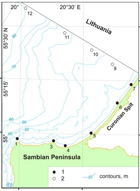
Fig. 1. Study area and location of stationary survey points of LUKOIL-KMN, Ltd. environmental monitoring: 1 – studied alongshore points; 2 – lateral profile points.
The aim of the present work is to summarize data on SMC collected over the last years along the northern coast of the Kaliningrad region as part of operational environmental monitoring of the marine oil production carried out by LUKOIL-KMN, Ltd.
- MATHERIAL AND METHODS
The research was carried out on 5-year (2011-2015) monthly data-array, collected within spring-summer season (April to October) (fig. 1). The whole route length was about 70 km – from cape Taran to Lithuanian border. The sampling was made coastwise to the north from the Kaliningrad Peninsula and the Curonian Spit. As a result, 6 points (stations) with 2-horizonts (surface and sub-bottom) were made. Suspended matter was then separated from water samples by the mean of pressurized ultrafiltration with a use of previously weighted nuclear filters (0.45 µm membrane diameter) to determine concentration. Interannual and seasonal averaged SMC data were calculated. The simultaneous vertical CTD-profiling (Idronaut 316 probe) was made at all 6 route points, so water temperature and salinity averaged sections can be plotted.
The transition from individual profiling series to the averaged seasonal profiles was performed with the method of layer-by-layer median filtering [9]. The key point of the approach is to calculate the median value for a layer with arbitrary thickness (in this study this parameter was taken as 1m).
- RESULTS AND DISCUSSION
In general, alongshore distributions of both annual averaged surface and near-bottom SMC demonstrate similarity (fig. 2). However, surface SMC is higher than near-bottom, and annual variations are more contrast. During entire period, increased SMC values with maximum in st. 4 were recorded at the Sambian Peninsula, while decreased values with minimum in st. 7 (close to Lithuanian border) were found at the middle of the Curonian Spit. Anyway, annual variability of SMC is quite high. Highest annual averaged SMC along almost whole investigated coastal zone were recorded in the 2015.
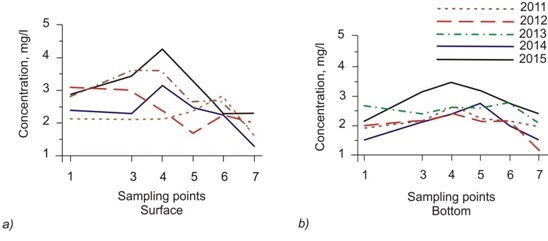
Fig. 2. Annual averaged suspended matter concentration at fixed survey points of monitoring along northern coast of Kaliningrad Region: a) surface layer, b) near-bottom layer.
Data discussed here corresponds with previously obtained results [8]. Maximum values within both near-bottom and surface layers were observed near eastern part of the northern coast of the Sambian Peninsula (fig. 3). However, our data demonstrates that SMC maximum moves to the east – from st. 3 (cape Gvardeysky) to st. 4. Anyway, this evidence do not contradict with an opinion that adjacent coastal area and underwater coastal slope are the main sources of suspended matter for the entire considered coastal area.
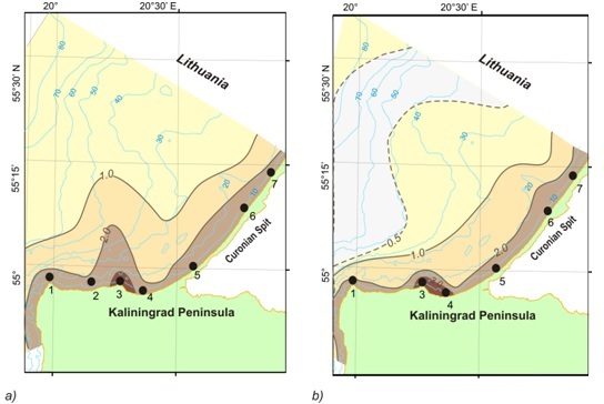
Fig. 3. Interannual averaged (2003-2008) surface suspended matter concentration (mg/l):
a) surface layer (0-1 m); b) near-bottom layer (1-2 m from the bottom); black dots – studied alongshore points
The main features of the spatial distribution of suspended matter in the interannual time scale are clearly visible on the lateral profile along the Lithuanian border (fig. 4, after [8]). Seaward, coastal concentration maximum of the suspended matter transforms into subsurface “tongue” with the thickness 10-15 m which is visible at a distance of 50 km from the coastal zone. Near-bottom maximum is located close to center of the Gdansk Basin beginning from a depth 50-60 m.
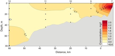
Fig. 4. Distribution of the interannual averaged suspended matter concentrations on the lateral profile from middle part of the Curonian Spit along the Russian-Lithuanian border (see fig. 1, after [8])
Our finding completes previous beliefs about suspended matter distribution in the studied area on the alongshore profiles. Interannual averaged and seasonal SMC data are shown on the hydrological section (fig. 5). For regional hydrological conditions the period from January to March is meant winter, April-June – the spring, July to September – the summer, October-December – autumn [10]. Therefore, there are two full seasons (spring and summer) and October during the time of observation.
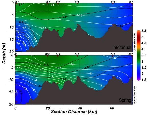
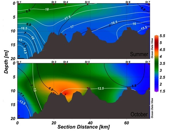
Fig. 5. Averaged SMC (color gradations) and hydrological conditions (white isolines – salinity (psu); black – temperature (°C); red dots – sample points of SMC
The peak of suspended matter concentration appeared to be located at station 3 and 4, which are nearby the Kaliningrad peninsula. Both the interannual and seasonal pictures show this maximum, besides the highest concentrations occur in October. SMC tend to decrease significantly towards to the Curonian spit, which provides us to the following observation.
Two types of SMC vertical distribution is revealed on interannual section:
Sambian Peninsula coastal zone (stations 1, 3, 4) is characterized by vertical stratification of SMC, while Curonian Spit coastal zone (stations 5-7) – by homogenous distribution of latter. Transition from one stratification type to another takes place near eastern part of Sambian Peninsula (between st. 4 and 5).
Vertical stratification (first type) may maintain when vertical suspended matter movements prevailed, while homogenous distribution (second type) indicate prevailing of the horizontal transport of SMC.
Interannual hydrological structure appears to be less vertically stratified over the entire section; there are no strong gradient zones which can prevent suspended matter transport.
Spring distribution of SMC follows the same pattern as interannual one, along with hydrological structure. Total summer SMC are slightly lower, than in spring. Two types of vertical suspended matter distribution are not clearly visible during summer. In autumn (October) highest SMC values are recorded (influence of beginning of the storm season). Two types of SMC distribution are clearly visible.
It appeared, that summer data shows specific feature – signs of cellular circulation with border at station 3 (cape Gvardeysky). According to [5], circulating cells form inside bays during weak wind conditions. There are strong and storm winds, which destroy those cells and carry sediments towards an open sea. The main run-off of bed load takes place along skirts of bays, infront of capes. During west winds influence, compensating water and sediment outflow focus on eastern bay shores.
According to our data, we can assume that this process is vivid nearby the Gvardeysky cape (st. 3), where the concentration maximum is. The same maximum was observed in [10].
- CONCLUSIONS
The maximum of SMC is situated alongside the Kaliningrad peninsula, the decrease in concentration takes place towards to the Cronian Spit. Consequently, two types of SMC vertical distribution is recorded on interannual and seasonal alongshore sections: Sambian Peninsula coastal zone is characterized by vertical stratification of SMC, while Curonian Spit coastal zone – by homogenous distribution of latter.
Our findings confirm that the main source of suspended matter for the northern coast area of the Kaliningrad region is located near the middle and eastern part of the northern coast of Sambian Peninsula (cape Gvardeysky).
- The work was financed by the RSF grant 14-37-00047. Authors are grateful to L.D. Bashirova for language editing and help with artwork.
1. E.M. Emelyanov. “Sedimentogenesis in basin of the Atlantic Ocean”, Moscow: Nauka, 1982, pp.190 (in Russian).
2. E.M. Emelyanov. “Geochemistry of suspended matter and bottom sediments of the Gdansk Basin and processes of sedimentation” in Geology of the Gdansk Basin. Baltic Sea, Kaliningrad: Yantarny skaz, 2002, pp. 220-302.
3. E.M. Emelyanov. “Quantitative distribution of suspended matter along Kaliningrad Peninsula and Curonian Spit (Baltic sea)”, Oceanological research, no 18, 1968, pp. 203-213.
4. V.V. Sivkov. “Suspended matter in the water”, in Neft' i okruzhayushchaya sreda Kaliningradskoj oblasti. Tom II: More (Oil and the Environment of the Kaliningrad Region. Volume II: Sea), Kaliningrad: Terra Baltica, 2012, pp. 120-128.
5. A. N. Babakov. “Dynamics of Sedimentary Substances in the Coastal Zone of the Sea”, in Oil and the Environment of the Kaliningrad Region. Volume II: Sea, Kaliningrad: Terra Baltica, 2012, pp. 37-59.
6. A.B. Kozhakhmetov, V. M. Latschenkov. “Preliminary results of determining of background turbidity on the aggradation area of free sandy beach loads at northern coast of Sambian Peninsula”, in Problems of geomorphology and Quaternary geology of the shelf seas, Kaliningrad: 1989, pp. 96-99.
7. A.I. Blazhchishin, A.N. Babakov, V.A. Tschechko. “Concentration and contamination of suspended loads of the Kaliningrad near-shore zone”, in Problems of studying and protection of the Curonian Spit, Kaliningrad: AB IO RAS, 1998, pp. 31-58.
8. V. Ph. Dubravin, E.V. Dorokhova, V.V. Sivkov, V.A. Smyslov, “Hydrochemical figures and suspended matter”, in Oil and the Environment of the Kaliningrad Region. Volume II: Sea, Kaliningrad: Terra Baltica, 2012, pp 276-291.
9. I. M. Belkin, Morphological and Statistical Analysis of the Ocean Stratification, Leningrad: Gidrometeoizdat, 1991, 130 p.
10. V. Ph. Dubravin, Zh. I. Stont, “Hydrometeorological Mode, Water Structure and Circulation,” in Oil and the Environment of the Kaliningrad Region. Volume II: Sea, Kaliningrad: Terra Baltica, 2012, pp. 69-105.