


BISAC NAT010000 Ecology
BISAC NAT045050 Ecosystems & Habitats / Coastal Regions & Shorelines
BISAC NAT025000 Ecosystems & Habitats / Oceans & Seas
BISAC NAT045030 Ecosystems & Habitats / Polar Regions
BISAC SCI081000 Earth Sciences / Hydrology
BISAC SCI092000 Global Warming & Climate Change
BISAC SCI020000 Life Sciences / Ecology
BISAC SCI039000 Life Sciences / Marine Biology
BISAC SOC053000 Regional Studies
BISAC TEC060000 Marine & Naval
A construction of breakwaters and other shoreline structures on part of a coast influences drift sand transport in the bay, and causes comprehensive topographic changes on the beach. This study investigated shoreline and coastal changes, taking as an example of Shiraragahama Beach in Miiraku on the northwestern end of Fukue Island, Nagasaki Prefecture (Kyushu, Japan). Miiraku, adjacent to Saikai National Park, appears in the revered 8th century poetry collection “Manyoshu” and served as a port for a ship taken by the Japanese envoy to China during the Tang Dynasty (618-709). Because of the recent development of breakwaters for a fishing harbor, the shore environments of this beach have changed significantly. In this study, the status of silt deposits and topographic changes on this beach arising from the construction of a harbor breakwater were evaluated by comparing aerial photographs taken in different years. Next, the changes in the shoreline visible from aerial photographs from 1947 to 2014 were analyzed. Lastly, the altitude of the beaches was measured using accurate survey methods. The following results were obtained: 1) coastal erosion made rock cliffs to fall off along the shore and deposited sand on this beach; 2) the more serious advances or retreats of the shoreline took place around shoreline structures; 3) sandbars and beach cliffs were formed.
Goto Islands, pocket beach, shoreline structure, coastal changes, drift sand transport
I. Introduction
A beach is located in the place where the sea and the land meet and where the dynamic environment is formed by moving sand and seawater. This littoral zone provides a space for diversified ecosystems to thrive. It is also a place where humans use for social activities such as shipping of marine products and construction of harbors.
A sand beach has various functions. For example, it absorbs the wave energy from the ocean effectively and protects the hinterland directly. Indirectly, it gives a space for coastal vegetation which prevents winds from the ocean, thus offering a protection against any wind-driven damages such as sand drift and salt, in addition to fogs and tides. The beach is also an outstanding place for people to enjoy seascapes, to have local events and festivities, and simply to relax.
Japan is an island country surrounded by the sea on all sides, with the shoreline extending to approximately 35,000km. In Japan the mountainous districts occupy 70% of the land. Plains are a very important place for population, industries, and traffic and are concentrated on coastal areas. The most prosperous place of the human activities is located on coastal areas. Industries that support people’s living, such as the fishing industry and commerce, develop on coastal areas and people have been living there while having close relationships with the ocean since the ancient times.
On the other hand, because we heavily rely on the ocean for our diverse activities, rapid developments to construct reclaimed grounds and port facilities were pushed forward in coastal areas of Japan, especially during the postwar revival period. As a result, fine natural environments that not only offered the people the various regions in Japan the beautiful landscape like sandy beaches, tidelands and rocky coasts, but also supported peoples' lifestyles had disappeared. Once a beautiful stretch of sandy seashore dotted with pine trees, characteristic of the natural coast of Japan, had significantly changed. Therefore, immediate attentions must be paid to the conservation of beaches, and to balance the conservation of the coasts and a regional development is a very important issue at present.
This study aims at investigating the influences of drift sand transport and comprehensive topographic changes on Shiraragahama Beach by comparing aerial photographs taken in different times. To measure the altitude of the beaches, the accurate survey methods were employed.
II. CHARACTERISTIC OF AN INVESTIGATION TARGET AREA
Shiraragahama Beach is located in Miiraku on the northwestern end of Fukue Island in the East China Sea (Fig. 1). Miiraku, where it has a relatively warm climate and is a rainy region throughout the year due to the effect of Tsushima Current, is blessed with a richness of nature and inshore fisheries. Also, Miiraku is near Saikai National Park, and appears in the revered 8th century poetry collection “Manyoshu” and served as a port for a ship taken by the Japanese envoy to China during the Tang Dynasty (618-709). Thus, Shiraragahama Beach has a rich natural environment as well as being a place of great historic interests. Shiraragahama Beach is a typical pocket beach of approximately 1.7km length. This beach is exposed to waves coming from the north, and there is a headland in the center of it. There is an extensive dune in the southern part of Shiraragahama Beach and a tidal flat is exposed in a part of this beach. In 1950s, this was a rich natural coast covered with white sand and had a children’s playground to enjoy fishing. Also, this beach was once a continuous stretch of sandy beach from the west coast to the east at low tide, but now is completely discontinuous at the headland in the center of this beach as a boundary.
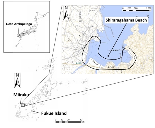
Fig. 1. The Location of Shiraragahama Beach in Miiraku on Fukue Island
III. THE STATUS OF SILT DEPOSITS AND COASTAL CHANGES
The status of silt deposits
Arc-GIS which is a comprehensive software system to collect, sort out, and accumulate the geographic information was used for the interpretation of the status of silt deposits and topographic changes on Shiraragahama Beach. Three aerial photographs taken from 1947 to 2014 when the major changes on the beach took place were chosen for the study.
Firstly, the status of silt deposits interpreted from the aerial photos in representative years on Shiraragahama Beach was evaluated. To quantitatively grasp the influence to drift sand transport caused by topographic changes, I set an outer flame along revetment walls, breakwaters and other shoreline structures in 2014 while taking land reclamation of streets and fishing ports into account, and calculated an area enclosed with the outer flame and the shoreline in each generation by using Arc-GIS.
As a result, at Shiraragahama Beach, the sandy beach which had a total area of 0.273km2 in 1947 has increased 0.1km2, covering the total area of 0.373km2 in 2014. This made it clear that this beach has increased approximately 37 % from 1947 to 2014 (Table. 1).
Table 1. An Area of Sandy Beach on Shiraragahama Beach
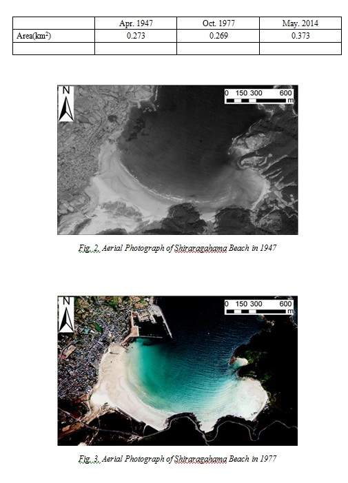
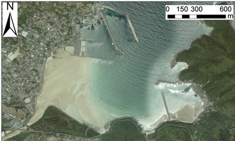
Fig. 4. Aerial Photograph of Shiraragahama Beach in 2014
Coastal changes
The coastal changes of Shiraragahama Beach were interpreted by comparing aerial photographs taken before and after the period when some breakwaters and other shoreline structures were constructed. Because breakwaters and sediment control groins at a fishing harbor were rapidly built on Shiraragahama Beach in various periods, the beach was divided into three segments to investigate more detailed coastal topographic changes (Fig. 5).
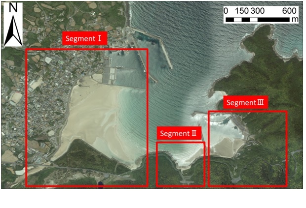
Fig. 5. Segments of Shiraragahama Beach
In segment I, the west of a headland located at the center of Shiraragahama Beach was eroded, and rocky areas came to be exposed because incident waves into this bay have changed the direction from the south to the southwest due to the expansion of shoreline structures and extension of breakwaters. Eroded sands were carried away towards the northwest by waves and gradually accumulated on the north side of Shiraragahama Beach. Also, a part of a tidal flat which existed in 1947 has been decreasing due to the development of residential areas and a construction of a park, and exists only partially at the estuary in 2014.
In segment II, it became clear that the erosion of the sandy beach was prominent. The cause of this incident is the same as segment I. The direction of incident waves have changed due to the extension of breakwaters. In addition, the supply-demand balance of the soil and sand may have been lost because the supply into Shiraragahama Beach from the east side was interrupted by a construction of a sediment control groin in 1990s and only the wave energy is transmitted onto Shiraragahama Beach today.
It is assumed that the accretion of sand in segment III is caused by the accumulation of soil and sand supplied from a river into the bay without being carried away into the sea because of the presence of the sediment control groin constructed in 1990s. Therefore, the east side of Shiraragahama Beach was turned into a stable topography.
IV. ANALYSIS OF SHORLINE CHANGES BY COMPARING AERIAL PHOTOGRAPHS
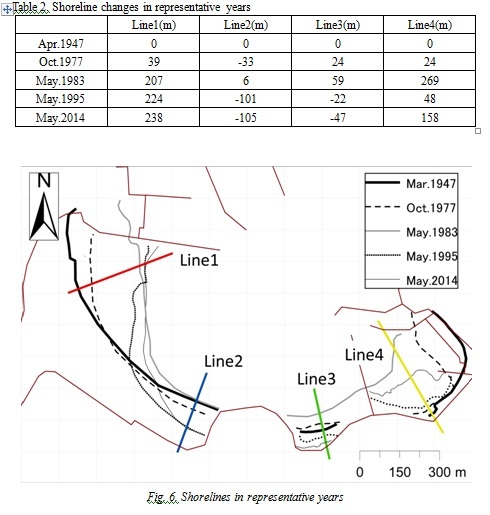
As with the area calculation, the analysis of the changes in the shoreline observed from the aerial photographs from 1947 to 2014 was made, and the distance of shoreline changes was quantified by using the Arc-GIS. In investigating shoreline changes, five aerial photographs taken from 1947 to 2014 were used for a comparison. Also, in measuring the distance of shoreline changes from aerial photographs, the shoreline in 1947 was made as a starting point at 0m. The changes in shoreline distance before and after it were expressed in +/- in the graphs. As the shoreline in 1947 being a reference point, lines were drawn at four points where large changes in the shoreline were observed, and the distance of the shoreline advanced or recessed was evaluated (Fig. 6).
As a result, it became apparent that shorelines advanced over 200m and retreated over 100m in Shiraragahama Beach, and the beach profile in Shiraragahama Beach was changed significantly from 1947 to 2014 (Fig. 7). The shoreline advanced 238m on Line1 and retreated 105m on Line2 during 67 years from 1947 to 2014. The reason may be that the shape of an entrance of the bay to Shiraragahama Beach was changed by the construction of the sediment control groin on a headland located on the east, and a large amount of sand from the south of Shiraragahama Beach has accumulated into the north. In addition, the shoreline of Line3 advanced 59m between 1947 and 1983, then retreated 47m in 2014. This reason is assumed that the influence of the sediment control groin constructed in 1990s on a headland located on the east was prominent. It was confirmed that shorelines on Line4 changed just like Line2 and Line3. The distance of the shoreline on Line4 advanced 269m between 1947 and 1983, then retreated 111m from 1983 and became 158m in 2014. The reason is because the inside of a fishing port on the east side became less affected by waves and winds because of the presence of the sediment control groin, and soil and sand supplied from a river were accumulated into the bay without flowing into the sea.
.jpg)
Fig. 7. Graphs of shoreline changes
V. EVALUATION OF MICROTOPOGRAHY USING ACCURATE SURVEY METHODS
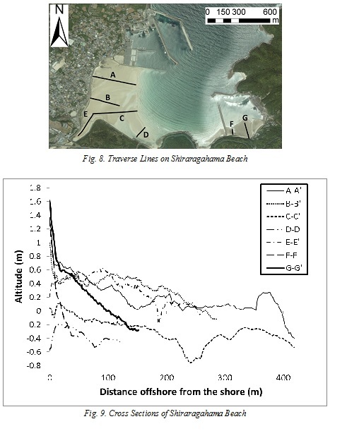
The topographic characteristics of Shiraragahama Beach such as wind-blown sand deposits and sandbars were expressed in cross sections by measuring the altitude of Shiraragahama Beach using RTK-GPS on site. On the beach survey, seven traverse lines from A to G were set as a representative traverse line (Fig. 8).
Fig. 9 shows the results of the Shiraragahama Beach survey in September and October, 2015. On A traverse line, a verified formation of a sandbar located approximately 350m away from the shore in the field survey corresponds to the cross section. It is assumed that concavity in cross sections of B and C traverse lines is a water way from Masabuchi River into Shiraragahama Beach. The beach around D traverse line is eroded remarkably, and a sudden incline in 15m from the shore is due to the influence of the erosion along the revetment. Around F and G traverse lines measured in the east side of Shiraragahama Beach, not much relief on the beach was observed in the field survey, and the slopes in cross segments were in a constant gradient. In addition, in calculating the altitude between traverse lines on Arc-GIS, it was confirmed that on the west of Shiraragahama Beach the altitude is higher in the northwest, and overall the southeast is lower. As is evident from the result of shoreline changes, differences in the altitude demonstrated that the remarkable influence of the beach erosion was observed on Shiraragahama Beach.
VI. CONCLUDING REMARKS
Shiraragahama Beach which was a subject to the process of waves for a long time was once a stable beach, and had pristine natural environments such as shore reefs and a tidal flat. Currently, it became apparent that large quantities of sand was accumulated on Shiraragahama Beach due to shielding effects against waves by breakwaters in Miiraku fishing port while a headland located in the center became eroded. A significance change in the form of sandy beach occurred on Shiraragahama Beach, but the different topographic changes occurred in each segment. A principal cause of topographic change on Shiraragahama Beach is due to the discrete advancement of projects without making comprehensive plans up to the present time. Hereafter, in order to balance natural and historic landscape and to improve regional development, more detailed segmentations must be considered on similar beaches and a more comprehensive management of the entire bay will be necessary.
VII. ACKNOWLEGEMENT
I would like to give heartfelt thanks to Yoshito Sakurai and Shintaro Kosaka whose comments and suggestions were of inestimable value for my study. Special thanks also go to Dr. Iwasaki whose comments made enormous contribution to my work. Finally, funding from Ministry of the Environment is gratefully acknowledged.
1. T. Uda, M. Serizawa, T. San-nami, K. Furuike, “Shoreline Changes of a Pocket Beach Caused by Elongation of Harbor Breakwater and their Prediction,” Japanese geomorphological Union, Kyoto, 23-3, pp. 395-413, 2002.
2. S. Unoki, “Coastal physical oceanography,” Tokai University Press, Kanagawa, pp. 560-572, 1993. (in Japanese)
3. Paul D. Komar, “Beach Processes and Sedimentation, Second Edition,” Prentice-Hall, New Jersey, 544pp., 1998.
4. Miiraku City, “Local History of Miiraku City,” Miiraku City, Nagasaki, 723pp., 1988. (in Japanese)
5. Miiraku City Local History Making Committee, “Local History of Miiraku City,” Miiraku City, Nagasaki, 344pp., 2004 (in Japanese)
6. T. Uda, “Japan’s beach erosion : reality and future measures,” World Scientific Publishing, Singapore, 418pp., 2010.
7. J. William Kamphuis, “Introduction to Coastal Engineering and Management, 2nd Edition,” World Scientific Publishing, Singapore, 525pp., 2010.