


BISAC NAT010000 Ecology
BISAC NAT045050 Ecosystems & Habitats / Coastal Regions & Shorelines
BISAC NAT025000 Ecosystems & Habitats / Oceans & Seas
BISAC NAT045030 Ecosystems & Habitats / Polar Regions
BISAC SCI081000 Earth Sciences / Hydrology
BISAC SCI092000 Global Warming & Climate Change
BISAC SCI020000 Life Sciences / Ecology
BISAC SCI039000 Life Sciences / Marine Biology
BISAC SOC053000 Regional Studies
BISAC TEC060000 Marine & Naval
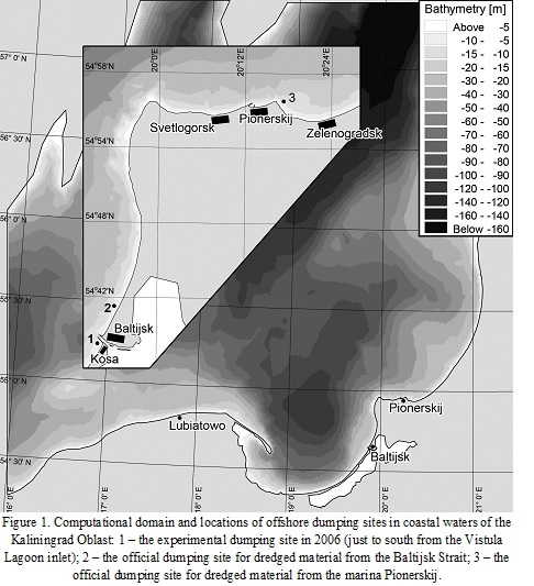
Three dumping sites located at the south-eastern part of the Baltic Sea (Kaliningrad Oblast) at shallow depths are considered. The first one is located to the south of the Vistula Lagoon inlet in front of a permanently eroded open marine shore segment. The second one is located to the north of the Vistula Lagoon inlet, and is used now for disposing of dredged material extracted from the Kaliningrad Seaway Canal. The third dumping site is located near the northern shore of the Sambian Peninsula to the east of the Cape Gvardeijski and assigned for disposing the dredged material extracted from the fairway to the Pionerskij Port located nearby. The last site is planned to be used for disposing of dredged material from the future port that should be constructed there before the beginning of the FIFA World Cup 2018. All three dumping sites are located not far from the eroded segments of the shore. The question behind the study is: would it possible that disposed material will naturally transported from the damping site to the shore and accumulate there to protect it from erosion? A numerical hydrodynamic-transport 3D model (MIKE) was used to model sediment transport under different wind actions. The winds with the speed stronger than 15 m/s complete wash out disposed material from the dumping site and spreading it over the wide area with a negligible layer thickness. Winds of about 7-10 m/s transport material along the shore at a distance of few kilometers that may be useful for shore protection. The first location of the dumping site (to the south of the Vistula Lagoon inlet) looks very ineffective for potential protection the shore nearby. At the other hand, the second and especially the third locations are favorable for transport of disposed material to the shore, the most favorable conditions are at onshore or alongshore currents.
dumping, sediment transport, numerical simulation, wind waves, near shore currents.
I. Introduction
It is known [1-3] that the entrances to marinas and ports in the South-Eastern Baltic are regularly filling by sand and, therefore, require periodic dredging. On the other hand, construction of any port on the open sea shore usually negatively influences on sediment balance in the location and coastal erosion very often becomes a problem after a port construction. Coastal protection would be the best use of the dredged material.
One of the places demanding constant deepening is the Baltijsk Strait, an inlet of the Vistula Lagoon (Figure 1), which hosts the main fairway connecting ports of Kaliningrad with the Baltic Sea. Entrance moles bounded this inlet from the marine side are obstacles for the alongshore sediment transport, and leeward erosion exists just to the south from the moles at a distance of 2.5-3 km [4, 5]. In June 2006 an experimental dumping of dredged materials were carried out in the vicinity of the eroded shore (insert of the Figure 1, site No 1). Unfortunately the result of the experiments was negative. Strengthening the coast at the Kosa Village, located opposite the dumping site No 1, did not happen. Detailed results of field measurements and numerical simulations given in [5] showed that the disposed material was transported along the shore and does not reach the shoreline under any landward wind conditions. It was concluded that the only effective suggestion which could strengthen the coast is to dispose dredged material directly onto the beach.
There are two regular offshore dumping sites (Figure 1, sites No 2 and 3) near the shore of the Kaliningrad Oblast that are used to dispose the dredged material. The dumping site No 2 is for the material dredged in the Baltijsk Strait. The dumping site No 3 is used to accumulate dredged material after the deepening of the marina near the town Pionerskij. This marina should be converted into a modern port before the beginning of the FIFA World Cup 2018. Consequently, the dumping site No 3 will be intensively used in the future.
The aim of the current paper is to analyze would the dredged material discharging on the dumping sites No 1, 2 and 3 be transported alongshore and serve to protect some part of the shore from erosion. The analysis is based on a numerical simulation.
II. Method
Simulations were performed using the software package MIKE, developed by DHI Software [6, 7]. A three-dimensional formulation (10 layers in depth, sigma-coordinate) was used for simulations. The computational domain covered a central part of the Baltic Proper (Figure 1). The depth field was taken from digital topography of the Baltic Sea [8]. Mesh sizes of irregular grid for the open sea were about 5-7 km, and in the vicinity of the dumping sites – about 100 m. All boundaries of the simulation area were closed, and wind was the only driving force in the model. It was assumed that wind measured in Baltijsk could be uniformly applied for the entire area of simulations. Such a model set-up showed its advantages for coupled hydrodynamic and wind waves simulations near the shore of the study area in [9, 10].
Three modules of the MIKE numerical models system were used. The Hydrodynamic Module gave the solutions (water level and currents) of 3-dimensional shallow water equations [7], the Spectral Wave Module solved the balance equation for the density of wave action [7], and the Mud Transport Module simulated the advection and dispersion of the admixture, including its settling and re-suspension [6]. All of them were used in coupled mode.
Calibration and verification.
The results of the calibration of the utilized model setup for the Hydrodynamic and Spectral Wave modules were presented in [9] and [10] respectively. The correlation coefficients between the measured and simulated currents and wave parameters were up to 0.8, and their maximal and average values were also comparable.
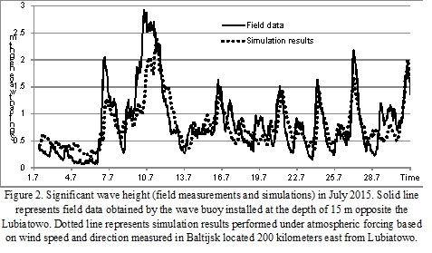
Utilized model setup is based on the assumption that wind speed and direction in computational area are uniform. Arguments behind are as follows: 1) satellite data [11] show that wind speed and direction over the Baltic Sea can be considered almost the same within the regions with a characteristic size from hundreds to thousands of kilometers; 2) the previous simulations [9, 10] showed a good agreement between field measured and simulated results for waves and currents while based on the same assumption. At last, the impressive results are shown in Figure 2. Solid line here represents field data obtained by the wave buoy of the IBW PAN[1] 1-31.07.2015 installed at the depth of 15 m opposite the Lubiatowo (see Figure 1). Dotted line represents simulation results. Simulations were performed for the point where the buoy was located but the wind speed and direction were measured by a meteorological station located in Baltijsk more than 200 kilometers far from Lubiatowo. In this case a good coincidence between field data and simulation results (correlation coefficient is higher than 0.8) shows that wind conditions over the Baltic Sea within hundreds of kilometers are similar.
Calibration of parameters of the Mud Transport Module was based on field data obtained in this field experiment in June 2006 [4] at the dumping site No 1 (see insert in the Figure 1). The measurements of particle size distribution were conducted for bottom sediments around the dumping site No 1 before and after the discharge of about 17000 m3 of dredged material with 70% of quartz sand with a median diameter of 0.7 mm. The measurements showed that a sediment spot was formed after the discharge and it was stretched along the southern entrance mole, then average thickness of the bed layer of the sediments was 15 cm. Related model parameters defining the settling and resuspension properties of the particles were the following: the settling velocity according to the Stocks formula was 0.004 m/s; critical shear stress for erosion was taken 0.01 N/m2. Simulations reproduced the conditions of the field experiment, a calculated bed layer thickness was 17 cm and the calculated sediment distribution at the bottom was similar to the observed distribution (see details in [5]). All coefficients obtained during calibration were used in the simulations described below.
Model setup for dumping scenarios.
This paper presents the results of simulations of dumping events at all three dumping sites mentioned above. The amount of the material that was discharged in the model scenarios was 17000 m3 (as in experimental dumping of 2006 on the site No 1). The dumping event lasts 20 minutes, i.e. the source with discharge of 14 m3/s was assigned at the top computational sigma-layer. The depth of the sea at the dumping site locations was very similar: dumping site number No 1 – 8.1 m; dumping site number No 2 – 8.8 m; dumping site number No 3 – 8.8 m.
The model simulated first the settling of sediments on the bottom and formation of some spot of the deposits around the place of dumping, and then these sediments were resuspended by waves and transported by currents further from the dumping site. 24 model scenarios of constant wind action were simulated: the wind of 5, 7, 10 and 15 m/sec blows from five main directions - SW (225°), W (270°), NW (315°), N (0°), NE (45°) and E (90°).
The wind speed varied during the scenario as following: it started at a rate of 3 m/sec (for all scenarios) and was constant within 12 hours from the beginning of the scenario. After that the dumping event occurred (20 minutes) but the wind speed remained 3 m/sec another 12 hours. Then the speed increased instantly up to the wind rate of the scenario and remained constant within 24 hours. Then a period of "calm" weather started, i.e. the wind speed dropped instantly to 3 m/sec (for all scenarios) and stayed constant within 24 hours. It was assumed that most of sediments will be settle down during the "calm" period.
III. Results and discussion
Simulations showed that for all dumping sites which have similar depth (8-9 m) a wind with 5 m/s is not strong enough to resuspend sediments and move it to another place. At the other hand a strong wind (more than 15 m/s) blowing about 24 hours completely washed out the initial sediment spot at the dumping site and spreads sediments to such a wide area that thickness of the layer after subsequent deposition is negligible (Table 1). So, the only winds in the range 5-15 m/s would be favorable for redepositing sediments from the dumping sites to the nearest segments of the shore.
Dumping site No 1.
It was shown [5] that no landward wind action bring sediments from dumping site No 1 to the shore opposite it, and therefore, the beach near the Kosa Village would not be protected by disposal of dredged material to this dumping site. Simulation of NE wind made in the current study showed that bottom currents are directed landward (Figure 3a) while the currents in the top layer are oriented mainly along the shore and a little bit seaward. This causes resuspended sediments to spread along the shore of the Vistula Spit and settle down along 10 km from the dumping site. In modeling simulations we obtained that near-bottom currents are capable to transport the particles of 0.7 mm. The same result was reported in [12] by comparison of POM modeling results with Hjulstrom diagram.
In addition, the N and NE winds produce the situation of upwelling near the shore of the Kosa Village. The upwelling itself is developing at some distance seaward from the shoreline [13], but the lateral strip of water near the shore traps sediments resuspensded from the dumping site.
Table 1. The fate of the sediments disposed at the dumping sites after the influence of different winds: “No” – there is no deposition near the shore, sediments are transported seaward but not very far from the dumping site; “Yes” – sediments are settled near the shore not far away from the dumping site, “0” – sediments are not washed from the dumping site due to low currents, “Far” - sediments are transported near the shore very far from the dumping site and are dispersed along the big distance, “∞” – sediments are washed out from the dumping site completely and spread over the huge area, the layer thickness is negligible.[1] Institute of Hydroengineering of the Polish Academy of Sciences, Gdansk, Poland
|
Wind range |
Probability, % |
Modelled wind speed |
Dumping site No 1 |
Dumping site No 2 |
Dumping site No 3 |
|
SW, 2-5 m/s |
5.16 |
SW, 5 m/s |
No |
No |
0 |
|
SW, 6-9 m/s |
7.19 |
SW, 7 m/s |
Far |
Far |
No |
|
SW, 10-13 m/s |
1.38 |
SW, 10 m/s |
Far |
∞ |
Yes |
|
SW, 14-17 m/s |
0.24 |
SW, 15 m/s |
∞ |
∞ |
∞ |
|
W, 2-5 m/s |
4.01 |
W, 5 m/s |
0 |
No |
0 |
|
W, 6-9 m/s |
6.38 |
W, 7 m/s |
No |
Far |
Yes |
|
W, 10-13 m/s |
2.76 |
W, 10 m/s |
Far |
Far |
Far |
|
W, 14-17 m/s |
0.74 |
W, 15 m/s |
∞ |
∞ |
∞ |
|
NW, 2-5 m/s |
6.04 |
NW, 5 m/s |
0 |
0 |
0 |
|
NW, 6-9 m/s |
5.55 |
NW, 7 m/s |
No |
No |
Yes |
|
NW, 10-13 m/s |
1.06 |
NW, 10 m/s |
No |
Far |
Far |
|
NW, 14-17 m/s |
0.3 |
NW, 15 m/s |
Far |
∞ |
∞ |
|
N, 2-5 m/s |
5.97 |
N, 5 m/s |
0 |
No |
Yes |
|
N, 6-9 m/s |
2.54 |
N, 7 m/s |
0 |
Far |
Yes |
|
N, 10-13 m/s |
0.22 |
N, 10 m/s |
No |
∞ |
Yes |
|
N, 14-17 m/s |
0.06 |
N, 15 m/s |
Far |
∞ |
Far |
|
NE, 2-5 m/s |
5.44 |
NE, 5 m/s |
0 |
Yes |
0 |
|
NE, 6-9 m/s |
1.01 |
NE, 7 m/s |
0 |
Yes |
Yes |
|
NE, 10-13 m/s |
0.03 |
NE, 10 m/s |
Yes |
Far |
Far |
|
NE, 14-17 m/s |
- |
NE, 15 m/s |
Far |
∞ |
∞ |
|
E, 2-5 m/s |
9.46 |
E, 5 m/s |
0 |
0 |
Yes |
|
E, 6-9 m/s |
1.62 |
E, 7 m/s |
0 |
Yes |
Yes |
|
E, 10-13 m/s |
0.3 |
E, 10 m/s |
0 |
Yes |
∞ |
|
E, 14-17 m/s |
- |
E, 15 m/s |
Yes |
Far |
∞ |
(светлые графики).jpg)
Dumping site No 2.
Simulations show that only in case of moderate winds (7-10 m/s) from the north (wind direction 0°) and north-east (wind direction 45°) we can see possible deposition near the shore (Figure 4a, b). Sediments spread significantly larger under wind with higher speed, they can settle down near the entrance to the Vistula Lagoon, round entrance moles and settle down along the shore, and even to come into the Vistula Lagoon.
This behavior can be explained by the same reason as in the previous case: for NE wind currents in bottom layer have a noticeable component that is oriented toward the shore. For other wind directions a seaward component of currents speed is dominated and no deposition along the shore was simulated.
Dumping site No 3.
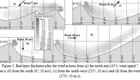
Simulation showed that disposal of sediments at the dumping site No 3 is followed by their sedimentation along the shore (Figure 5). Moderate wind actions (7-10 m/s) from south-west, west, north and north-east lead to the export of the sediments towards the beach.
IV. Conclusions
1) Winds with the speed of about 5 m/s or less do not lead to resuspension of the sediments at the dumping sites located at the depths of about 8-9 m.
2) The winds with the speed stronger than 15 m/s lead to the complete washing out of disposed material from the dumping site and spreading it over the wide area with a negligible layer thickness.
3) From the point of potential protection of the shore near a dumping site the best option would be the winds of about 7-10 m/s, which wash out disposed material and transported it along the shore at a distance of few kilometers.
4) For the dumping sites located at the western shore of the Sambian Peninsula (sites No 1 and 2) the winds with alongshore (southward) and seaward components may transport sediments towards the shore; but the probability of such winds are rather low – not more than 8.4%.
5) For the dumping site at the northern shore of the Sambian Peninsula (site No 3), the probability of favorable wind is much bigger (in total 28.6%): SW, W, N, NE and E winds.
Acknowledgement
Authors thank colleagues from the Department of Coastal Engineering and Dynamics of the Institute of Hydroengineering of the Polish Academy of Sciences for providing the data for wave measurements for calibration of the model. Research and preparation of this article were supported by the Russian National Foundation: the study for the dumping sites No1 and 2, located at the Vistula Spit, – by the Project No 14-17-00547 “A forecast development for evolution of accumulative Russian coasts of tideless seas”, and the analysis of situation around the dumping site No 3 – by the Project No. 14-37-00047 “Geoecological conditions of maritime use in the Russian sector of the South-Eastern Baltic”.
1. Aibulatov, N.A., Bass, O.V., 1983. Anthropogenic factor in the development of Baltic Sea coastal zone. Water Resources 3, 127-134. [In Russian].
2. Basinski T., Zmudzinski L., 1988. Poland. In H.J. Walker (Ed.), Artificial structures and shorelines, Kluwer Academic Publishers, Dordrecht-Boston-London, 67-80.
3. Boldyrev, V.L., 1988. USSR - Baltic Sea. In H.J. Walker (Ed.), Artificial structures and shorelines, Kluwer Academic Publishers, Dordrecht-Boston-London, 47-52.
4. Chechko, V.A., Chubarenko, B.V., Boldyrev, V.L., Bobykina, V.P., Kurchenko, V.Yu., Domnin D.A., 2008. Dynamics of the marine coastal zone of the sea near the entrance moles of the Kaliningrad Seaway Channel. Water Resources 35 (6). 652-661.
5. Chechko, V., Sokolov, A., Chubarenko, B., Dikii, D., Topchaya, V., 2015. Dynamics of sediments disposed in the marine coastal zone near the Vistula Lagoon inlet, south-eastern part of the Baltic Sea. Baltica 28 (2), 189-199. Vilnius.
6. MIKE21&MIKE3, 2007. MIKE 21 & MIKE 3 Flow model FM. Mud transport module. Short description. DHI software, DHI Water and Environment, Horsholm, 12 pp. http://www.mikepoweredbydhi.com/upload/dhisoftwarearchive/shortdescriptions/marine/mudtransportmodulemt.pdf (last call 23.08.2015).
7. MIKE 3/21 model, 2004. MIKE 3/21 Flow model FM. Hydrodynamic and transport module: Short description (Hydrodynamic Module, Spectral Waves FM). DHI Software, DHI Water and Environment, Horsholm, 48 pp. http://naturstyrelsen.dk/media/nst /65583/54335_bluereef_actiona2_hyd_appendixa_short_descriptions.pdf (last call 23.08.2015).
8. Seifert, T., Kayser, B., 1995. A high resolution spherical grid topography of the Baltic Sea. Meereswissenschaftliche Berichte 9, 72-88.
9. Sokolov, A.N, Chubarenko, B.V., 2012. Wind influence on the formation of nearshore currents in the Southern Baltic: numerical modelling results. Archives of Hydroengineering and Environmental Mechanics 59 (1-2), 37-48.
10. Sokolov, A.N, Chubarenko, B.V., 2014. Analysis of possible influence of climate changes on the wind wave parameters in the nearshore zone of the South-Eastern Baltic. Transactions of Kaliningrad State Technical University 34, 43-52. [In Russian].
11. The Ocean Surface Winds Team (OSWT) of the Center for Satellite Application and Research, http://manati.star.nesdis.noaa.gov/index.php (25.04.2016)
12. Golenko M. N., Golenko N. N., Emelyanov E. M., Nekrasov M. A. Influence of Quasi-Geostrophic Currents and Inertial Waves on the Elution of Fine Sediments in the Southeast Baltic // Oceanology, 2016, Vol. 56, No. 2, pp. 200-204. DOI:https://doi.org/10.1134/S0001437016020077
13. Esiukova E.E, Chubarenko I.P., Sinyukhin A.O. How to differentiate between coastal cooling and upwelling events on SST images? // Baltic International Symposium (BALTIC), 2014 IEEE/OES, 27-29 May 2014, Tallinn, Estonia. - Publisher: IEEE. - p. 1-7. - Print ISBN: 978-1-4799-5707-1, DOIhttps://doi.org/10.1109/BALTIC.2014.6887839