


BISAC NAT010000 Ecology
BISAC NAT045050 Ecosystems & Habitats / Coastal Regions & Shorelines
BISAC NAT025000 Ecosystems & Habitats / Oceans & Seas
BISAC NAT045030 Ecosystems & Habitats / Polar Regions
BISAC SCI081000 Earth Sciences / Hydrology
BISAC SCI092000 Global Warming & Climate Change
BISAC SCI020000 Life Sciences / Ecology
BISAC SCI039000 Life Sciences / Marine Biology
BISAC SOC053000 Regional Studies
BISAC TEC060000 Marine & Naval
In implementation of the Bucharest Convention (http://www.blacksea-commission.org/), the first regional List of Black Sea (BS) Hot Spots (HSs) has been prepared in 1996. It included municipal and industrial sources of pollution located in the BS coastal zone. Since then, the regional HSs List has not substantially changed, although a few non-harmonised revisions have been undertaken at national levels. The non-harmonization occurred due to the lack of an agreed regional methodology, which would clearly specify the term ‘hot spot’ and give criteria for HSs identification and ranking in support of decision-making in BS protection. Recognising this gap in the knowledge-based management of BS land-based sources of pollution (LBSs), in 2015we developed such a methodology and undertook revision of the regional BS HSs List. To automate the HSs Methodology application we developed a unique BS LBSs Database and a HSs software. This paper presents our approach to hot spots evaluation, which is applicable to any other sea. Results of identification and prioritization of BS HSs are discussed in view of their crucial role in managing risks to coastal regions and in investment planning aimed at reduction of BS pollution.
Land-based pollution sources, hot spots, identification, prioritization, Black Sea
I. Introduction
The Bucharest Convention 1992 (Convention on the Protection of the Black Sea (BS) Against Pollution, http://www.blacksea-commission.org/) sets out the overall objectives and obligations of the contracting Parties (Bulgaria, Georgia, Romania, Russian Federation, Turkey and Ukraine) in Black Sea protection, the actual implementation of each of these is to be done through more detailed and specific Protocols. In 1994, the Black Sea States have ratified the following implementing Protocols [1]:
- The Protocol on Protection of the Black Sea Marine Environment Against Pollution from Land-Based Sources (LBSs) ;
- Protocol on Cooperation in Combating Pollution of the Black Sea Marine Environment by Oil and Other Harmful Substances in Emergency Situations;
- Protocol on the Protection of the Black Sea Marine Environment Against Pollution by Dumping.
(Note: The Black Sea Biodiversity and Landscape Conservation Protocol to the Convention on the Protection of the Black Sea Against Pollution was signed in Sofia, Bulgaria in 2002 [2] (exception is Georgia, signatory since 2009), and entered into force in 2011; the 1992 LBS Protocol was revised and signed in 2009 [3]).
In 1996, the Bucharest Convention implementation was given a tight time-frame through an ambitious Strategic Action Plan (SAP [4], currently replaced by [5]) and the first regional List of BS Hot Spots (HSs) was prepared shortly before [6]. Worth mentioning is that in the mid-1990s there was no regionally agreed upon definition of HSs. Such a definition was given 14 years later in the revised LBSA (land-based sources and activities) Protocol, 2009 [3] which however remains unenforced. The BS SAP 1996 mentions the HSs List with the following: “It will provide the basis for the elaboration of national strategies and timetables for realising substantial reductions of inputs of pollutants from hot-spots, in accordance with agreed water quality objectives”.
The 1996BS HSs (total 50 in number) were identified using a “rapid assessment” methodology [7].For that purpose, the loads of point municipal and industrial sources of pollution located in the BS states’ coastal zones (although not well defined in national and regional legal/policy documents [8]) were inventoried and prioritised for further investigation. In the mean time, the ‘rapid assessment’ applied did not fully take important criteria into account: other sources of pollution in proximity (sensu cumulative effects), socio-economic developments in the HSs locations as well as the status of the impacted receiving environments versus their degradation’s root-causes (neither were properly assessed).The latter was due to the following shortcomings: In 1996 there were no regionally approved water quality standards. Unfortunately, they are still largely non-agreed upon and “BS environmental status” assessments are also not yet harmonised at regional level. Besides, pressure/impact analyses were and remain poorly developed in the BS countries, and there is also no common (regional), up-to-date understanding of BS “good environmental status”.
Since 1996 (already for 20 years), the regional HSs List has not substantially changed, though few revisions have been undertaken at national level yet, in a purely non-harmonised way. The national revisions included deletion of closed HSs or addition of new HSs, no prioritization was provided in parallel, having in mind the change in LBSs status with time (improvements or deterioration). Meanwhile, most of these revisions remained a mere scientific endeavour, and were never formally recognised by national governments. Consequently, they were never proposed to the Black Sea Commission (BSC, Commission on the Protection of the Black Sea Against Pollution, http://www.blacksea-commission.org/_commission.asp) for approval of amendments in the official regional HSs List and in the related national reporting under the Bucharest Convention. In this regard, since 2001, the BS HSs have been annually reported to the BSC following a regionally agreed upon Format. This Format contains no meta data on HSs and the HSs are characterised by their annual loads only (BOD5, nutrients, trace metals and other pollutants). The HBS Project Reports on LBSs management and monitoring [9, 10] narrate the current inconsistencies in LBSs data reported by the BS coastal states. Comparability of data is questioned in these reports having in mind the national monitoring practices employed and the lack of a regionally approved methodology on LBSs loads calculation.
The non-harmonization in HSs detection through the years since 1996 occurred due to the lack of an agreed upon BS regional methodology, which would clearly specify the term ‘hot spot’ and also give criteria for HSs identification and ranking in support of decision-making and investment planning.
Recognising this gap in the management of Black Sea land-based sources of pollution and the need to regularly update the official regional BS HSs List (two-yearly as required by the LBSA Protocol 2009), the HBS Project (http://bs-hotspots.eu/)[1] developed such a methodology and undertook a scientific-based revision of the regional BS HSs List. The definition of a hot spot, as given in the LBSA Protocol 2009, was taken into consideration and further developed. This definition is as follows: Hot Spot – means a limited and definable local land area, stretch of surface water or specific aquifer that is subject to excessive pollution and necessitates priority attention in order to prevent or reduce the actual or potential adverse impacts on human health, ecosystems or natural resources and amenities of economic importance.
The further developed definition by us says: Hot Spots are (a) Point sources on the coast of the Black Sea which potentially affect human health, ecosystems, biodiversity, sustainability or economy in a significant manner. They are the main points where high levels of pollution loads originating from domestic or industrial sources are being discharged; (b) Defined coastal areas where the coastal marine environment is subject to pollution from one or more point or diffused sources on the coast of the Black Sea which potentially affect human health in a significant manner, ecosystems, biodiversity, sustainability or economy. Thus, our definition covers two types of hot-spots: one in which there is major environmental activity affecting, or threatening to affect, the environment (needs prevention measures); and another in which the environment has already been affected to an extent that the environment is damaged or there exists a substantial threat of future damage (often needs ‘cure’ measures).
For the purpose of currently existing HSs identification and ranking, a unique LBSs Database was developed and a HSs software was linked to it. This software eases the application of the HSs Methodology as it contains not only expert judgement but also complicated mathematical calculations in examination of environmental and socio-economic impacts of LBSs. The LBSs Database contains detailed meta data and data collected for municipal and industrial sources of pollution which are located in the Black Sea Basin (some of them far upstream from the rivers flowing into the Black Sea or around lakes connected to the BS, but with a proven record of influence on the BS status).
Recently the HSs Methodology was proposed to the BSC for adoption and regular use in the region which would ensure the BS coastal states evaluate their LBSs in a harmonised way and would help them improve the national investment planning in BS protection.
This paper presents the Black Sea regional HSs Methodology, its Software (automated application of the Methodology) and the LBSs Database developed in support. Results of identification and prioritization of Black Sea hot spots are discussed in view of their crucial role in managing risks to Black Sea coastal regions environmental deterioration. The application of the HSs Methodology allowed the revision of the regional BS HSs List and gave indications on priorities in tackling pollution stemming from land-based municipal and industrial facilities to the Black Sea. In 2016, the revised BS HSs List was proposed for formal approval at national (by Ministries of Environment) and regional levels (by BSC).
The HSs Methodology is applicable to any other sea, it is universal in approach, although, the selection of its criteria depends very much on the availability of data on LBSs discharges, receiving environments status and standards (for discharges and water quality), and socio-economy indicators used in national statistics. In the Black Sea case study, the selection of criteria for HSs and candidates in HSs was based on a preliminary thorough examination of data availability and best available practices from other regional seas in identification and ranking of HSs. The paper gives an overview of the needed data requirements to pass through the various levels of LBSs screening (four in total) and communicates our decision on BS HSs ranking to support short, medium and long-term actions in the endeavour to improve the BS protection against pollution from land.
- The BS HSs methodology
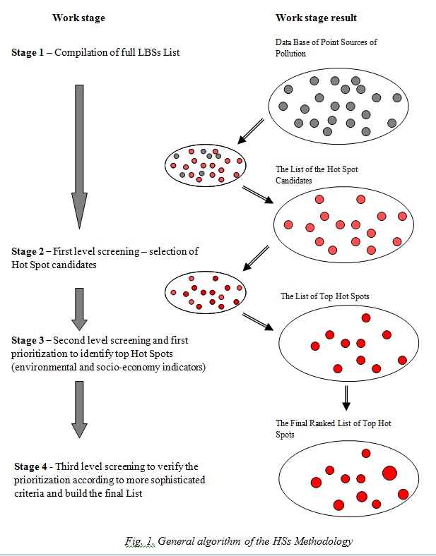
This methodology (Fig. 1) deals mainly with point LBSs as diffuse sources of pollution are poorly studied in the BS region. There is almost no quality data to properly assess them. Under “point”, we assume sources of pollution where emissions and releases are introduced into the environment from any discernable, confined and discrete conveyance, including but are not limited to pipes, outfalls, channels, ditches, tunnels, conduits or wells from which pollutants are or may be discharged. Diffuse sources are those which cannot be confined to a concrete point of discharge. The HSs Methodology gives indications on two diffuse sources identification and prioritization only: urban surface runoff and irrigation systems. The Methodology does not examine river and lake discharges as HSs, which are the most substantial sources of nutrients and pollutants to the BS.
The BS HSs Methodology was initiated in 2008 under the BSC activities using best available practices (BAPs). The draft BSC HSs Methodology was never finalised, although it was extensively discussed in the course of 8 years in the frames of the activities of the BSC LBS Advisory group (http://www.blacksea-commission.org/_ag-tor-lbs.asp). The utilised BAPs were of HELCOM (Baltic Marine Environment Protection Commission, http://www.helcom.fi/), UNEP-MAP/MEDPOL (United Nations Environment Programme, Mediterranean Action Plan for the Barcelona Convention (http://www.unepmap.org/index.php), and The MED POL Programme (the marine pollution assessment and control component of MAP [11]), ICPDR (International Commission for the Protection of the Danube River, https://www.icpdr.org/main/), Arctic Seas [12], GIWA (UNEP Global International Water Assessment, http://www.unep.org/dewa/giwa/), WHO (World Health Organization, http://www.who.int/en/ [13]), DABLAS (Danube/Black Sea Task Force, http://www.blacksea-commission.org/_dablas.asp), etc. in identification and prioritization of hot spots.
The HBS Project stepped on the BSC draft HSs Methodology, revising and further developing it into a modern knowledge-based document which carefully took into consideration the availability and reliability of meta data and data in the BS region.
We developed a List of HSs criteria which contains environmental, socio-economic and integrated indices [14]. Based on this List, and depending on the amount of final weight of a pollution source, 3 categories of HSs are being distinguished:
- The Hot Spot of the first rank is an entity that requires the most attention and prompt actions from decision makers.
- The Hot Spot of the second rank is an entity that requires attention from the decision makers and problem-solving in the short term (3 to 5 years).
- The Hot Spot of the third rank is an entity that requires constant attention on the part of decision makers and problem-solving in the medium term (5 to 10 years).
The candidate Hot Spots, outside of the List of top HSs, may obviously be addressed later in the long-term run (over 10 years).
Detail description of the BS HSs Methodology stages and indicators is given in [14].
- The BS HSs Software
The HSs Software automates the HSs Methodology application, extracting metadata and data from the LBSs Database. The Software requires additional online/manual data input (from Stage 3, Fig. 1) to allow full expert scoring and also the application of mathematical modelling where the candidate HSs effect on the BS environment is estimated [14]. The availability of such data was also checked and found satisfactory in all BS coastal states. The manual data/information input through the HSs Software (Fig. 2) includes:

Fig. 2. Example of the manual data/information input through the HSs software.
- Characteristics of flow and mixing in the receiving aquatic environment: it is necessary to know the type of water body into which the examined Hot Spot Candidate discharge is executed: e.g. river (with an indication of the type of river: large, small or medium), lake, liman/coastal salt lake (with the indication of: a half-open or weak mixing water), sea (with indication if the discharge is into a bay, open sea, etc.);
- Level of environmental hazard - receiving water body state: existing assessments of the state of the receiving water body or oxygen concentration (annual minimum, preferably for the bottom layer) in the waterbody at the site of the examined Hot Spot candidate discharge;
- Environmental tension at the location of the examined Hot Spot candidate: e.g. presence/absence of industrial enterprises or other sources of pollution in the vicinity, etc.
- The degree of local impact on water quality (characterizes the local impact of waste water discharge on the receiving aquatic environment taking into account the dilution of waste water by inland or sea waters): the depth of water body in the site of discharge (for discharges in sea and related surface waterbodies), river flow rate (if waste water is discharged into river), flow rate in the water body in the area of discharge (in the case of non-wind-drift current) or wind speed of 95% occurrence (if available), the location of discharge relative to shore (it is necessary to point out coastal or distant sea discharge or land-based source having discharges to water body connected with the Black Sea (e.g. river/lake);
- Presence of recreational and protected areas (national parks, nature reserves, wetlands, places of mass bird nesting etc.) in the vicinity of the Hot Spot and distance to them;
- Level of potential impact on aquatic life, including contamination of biota: concentration of heavy metals, expert assessment regarding the possibility of reducing oxygen content and shifts in the colour of water in the receiving water body, etc.;
- Investment attractiveness of the region/province (if available), or the value of Regional GDP per capita (note that you should have the following values of these parameters: minimum and maximum in the country and values for the Black Sea regions/administrative units where the examined Hot Spots are located; you also need to know (for each Hot Spot) the population size of the city/town/settlement/village where this Hot Spot is located);
- Prospects of development of the region/province: the birth rate and mortality rate (per 1,000) or the number of births and deaths as well as average population size (note that you should have the following values of these parameters: minimum and maximum in the country and values for the Black Sea regions/administrative units where the examined Hot Spots are located).
The data automatically derived from the LBSs Database by the HSs Software include:
- Name of the LBS and city/town/settlement of location;
- Coordinates of LBS location (on land and those where the discharge from it takes place (end of the pipe));
- Category of LBS (Industrial/ Municipal);
- Type of LBS (directly discharging to the Black Sea or not);
- Sub-type – point or multiple points;
- Type of waste water the LBS discharges – treated, untreated, insufficiently treated;
- Type of waste water treatment at the LBS – Mechanical, Biological, Chemical, etc. (or a combination);
- Receiving water body (to later identify its ecological status);
- Operating hours of the facility;
- Pollutants (concentrations and loads) in the waste water discharged by the LBS (for the second stage, a few parameters are needed to examine - BOD5, trace metals, nutrients, and oil products, however, the third and fourth stages of the HSs Methodology require an as full as possible list of pollutants contained in the waste water discharge to be compiled).
Based on the data listed above, the HS Software calculates environmental and socio-economic indicators, including the degree of overall HS impact on water quality (WQ), and/or assigns scores. The WQ impact calculation is based on the following three factors: the effective mass of a pollutant, the coefficient of relative toxicity of a pollutant and the coefficient taking into account processes of assimilation and respiration of a pollutant. WQ standards were chosen in line with those recommended by EU legislation [15] and applied in Bulgaria, Romania, Turkey and Ukraine.
The HSs ranking is done by multiplying the weight factors (Table 1, example of preliminary ranking – Stage 3 in Fig. 1) and the scores given to indicators (e.g. Table1, 3-9 columns). Example of scoring is given for the indicator Environmental tension (Table 2).
Table 1. Preliminary Hot Spot description
|
Name of Hot Spot candidate |
Location (town, region, country) |
Waste water discharge volume |
Distance to the Black Sea |
Population in HS town/village |
Type of waste water treatment used |
Characteristics of flow and mixing in the receiving aquatic environment |
Level of environmental hazard |
Environmental tension at the location of the Hot Spot candidate |
Final preliminary rank of the Hot Spot candidate |
|
Weight factor |
1 |
0.8 |
0.8 |
1 |
0.8 |
1 |
0.8 |
||
|
1 |
2 |
3 |
4 |
5 |
6 |
7 |
8 |
9 |
10 |
|
… |
|
|
|
|
|
|
|
|
|
Table 2. Environmental tension scoring
|
Score 1
|
environmental tension is absent – there are no other pollution sources in the vicinity |
|
Score 2 |
environmental tension is low - the source of pollution is situated within the borders of a village or urban settlement, where industrial facilities are absent |
|
Score 3 |
environmental tension is medium - the source of pollution is situated in a town, where significant industrial facilities are absent |
|
Score 4 |
environmental tension is high - the source of pollution is situated within the borders of a town, where there are middle-scale industrial facilities with no significant adverse impact on the environment (for example, facilities of food-processing, consumer goods production, woodworking industries, etc.) |
|
Score 5 |
environmental tension is very high – the source of pollution is situated within the boundaries of a town/city, where there are working enterprises of «hazardous» branches of industry (for example, chemical industry, heavy industry (metallurgy, machine building etc.) |
|
Score 6 |
environmental tension is extremely high – areas, which contain both large and/or harmful industrial activities and at the same time they are either PAs (or nearby), or bathing waters (nearby) or fishing grounds (nearby) |
Note: Similar scorings (classes of impact) are assigned to 12 other criteria/indicators used in the HS methodology for HSs identification and ranking.
- The BS LBSs Database (LBSs DB)
This Database (Manual and instructions on access at http://bs-hotspots.eu/Documents/Deliverables/HS%20DataBase%20Manual%20(ENG).pdf) is a tool in support of decision-making and investment planning. It ensures common LBS data management and generation of data products useful in BS environment protection management.
The Database (Fig. 3) contains point land-based sources which discharge directly or indirectly into the Black Sea. “Indirectly” means to other water bodies (surface waters), which are connected to the Black Sea. The point sources addressed include municipal and industrial facilities, rivers and lakes. So far BS LBSs detailed meta data and data on their discharges are collected and stored for the period 2010-2015.
For discharges, a total of 137 pollutants (8 major groups, Fig.4)) are included in the LBSs DB, as some of them are those discharged by industrial facilities into air and soil. Air and soil pollutants were included as a ‘forward-looking’ component of the LBSs DB. In future, such LBSs should also be addressed in BS HSs identification and prioritization.
.jpg)
The DB gives the opportunity to Search in it through various keys and produces four major reports. The meta data visualization is the first report and it appears in a Table and on a map (Fig. 5).The data visualization (Fig. 6, 7) includes the following three reports:
- Tables, which display the reported releases of a specific facility, or a River or a Lake for a specific year;
- Tables, which display aggregated releases of a specific industrial activity or an economic sector (includes facilities data only);
- Graphs, which display releases level for a specified pollutant – for a certain year and time series for a specified period.
The HS DB is harmonised with the European Pollutant Release and Transfer Register (E-PRTR,http://prtr.ec.europa.eu/Home.aspx).E-PRTR is the Europe-wide register that provides easy access to key environmental data from industrial facilities in the European Union (EU) Member States and in Iceland, Liechtenstein, Norway, Serbia and Switzerland.
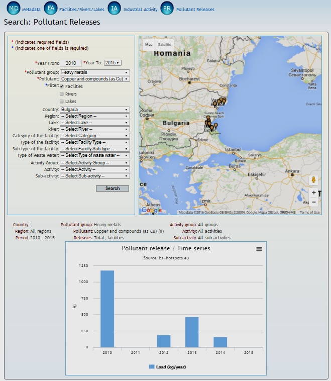
Fig. 6. Examples of Search options in the LBSs DB: Data Search (Pollutant releases – time series data for 2010-2015)
For further detail on Search options of the LBSs DBvisit:http://bs-hotspots.eu/Documents/Deliverables/HS%20DataBase%20Manual%20(ENG).pdf.
- Results of BS HSs identification and prioritization
The update of the regional BS HSs List was performed using the data collected in the LBSs DB and the HSs Methodology Software. Detail description of these results is given in [16].Total 187 BS LBSs (40industrial/ports/channels and 147municipal facilities; 58 directly and 129 indirectly discharging into the BS) were examined (Fig. 8). The general results of screening are presented in Figure 9 and Table 3. LBSs located in the Russian Federation (RF) were not screened as no recent data was available for them. According to data prior 2010, two industrial (Ballast water treatment plants in Tuapse and Novorossiysk) and eleven municipal facilities (WWTPs in Adler, Sochi (Kudepsta, Bzugu, Navaginskiye, Dagomis, Lazarevskiye), Tuapse, Gelendzhik (also Kabardinka), Novorossiysk and Anapa) are located along the RF coast.
In Crimea, the screening of LBSs confirmed the Hot Spot character of the following Waste Water Treatment Plants (WWTP): Sevastopol, Kerch, Yevpatoria, Balaklava and Yalta. In Bulgaria, Georgia, Romania, Turkey and Ukraine, the screened facilities were not only located at the BS coast. All LBSs within the boundaries of BS municipalities/regions (oblast, district) with potential impact on the BS were taken into consideration.
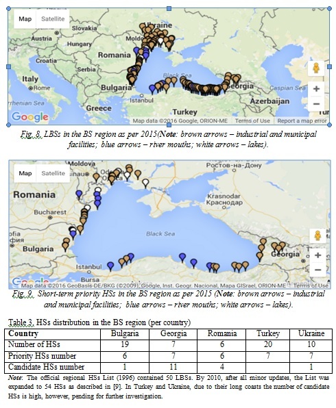
Therein, managing risks to BS coastal environments, minimum 38 LBSs (Table 4) require urgent measures (maximum in the course of 5 years). They are all with proven long-term negative record and lack of sufficient investments to tackle the related environmental problems.
Table 4. Priority HSs in the BS region as per 2015
|
Country/ region |
Bulgaria |
Georgia |
Crimea |
Romania |
Turkey |
Ukraine |
|
Name of HSs |
Varna WWTP |
Kutaisi municipal WWTP |
Sevastopol WWTP |
Constanta port |
Giresun Marine Outfall Discharge |
PivdenniWWTP, Odessa |
|
BurgasWWTP |
Batumi Oil Terminal* |
Balaklava WWTP |
Constanta South WWTP |
Trabzon Marine Outfall Discharge |
MykolaevWWTP |
|
|
Meden RudnikWWTP* |
Poti municipal WWTP |
Kerch WWTP |
Mangalia WWTP |
ZonguldakUWWTP |
Odessa urban surface run-off* |
|
|
Lukoil NeftohimBourgas AD |
Batumi WWTP |
YevpatoriaWWTP |
Constanta North WWTP |
Erdemir * |
Sea commercial port of Illichivsk |
|
|
Oilfield Tulenovo (Shabla) * |
Manganese ore mining and processing (Chiatura) |
Yalta WWTP |
Eforie South WWTP |
Rize Marine Outfall Discharge* |
Kherson WWTP |
|
|
SolveySodi AD (Devnya) |
Zestafoni ferroalloy factory |
|
SC ROMPETROLRAFINARE |
Bulancak UWW* |
Port Yuzhnii |
|
|
|
Zugdidi municipal |
|
|
Arakli Marine Outfall Discharge* |
PivnichniWWTP, Odessa |
|
|
Note: *means new for the BS regional HSs List; UWWTP – Urban Waste Water Treatment Plant; WWTP – they could collect also waters from industrial facilities and ports |
||||||
Thus, to the existing regional HSs List (54 LBSs as per 2015 after all minor revisions since 1996) seven new high priority HSs were added due to our screening, whereas two sources in Bulgaria (Asparuhovo and Sarafovo (quarters of the cities Varna and Burgas, respectively) – closed facilities), one source in Georgia (Tskhaltobo (resort) – candidate HS), four sources in Turkey (Bafra, Ordu, Samsun and Eregli – not confirmed) and one source in Ukraine (Krasnoperekopsk, bromide – closed facility) were excluded. Obviously, the regional HSs List has not shortened, despite all measures taken by the BS coastal states during the last decade [9, 16]. It increased to 62 LBSs as the lower priority sources added (3rd Rank, in need for investments in 5-10 years only) were high in number in Bulgaria and Turkey.
- Acknowledgement
This paper was prepared as a follow-up of the HBS Project and the authors gratefully acknowledge the contribution of all colleagues and stakeholders who helped to collect large meta data and data sets, prepare the HSs methodology and its software as well as to develop and nourish the LBSs Database. Without the constant support of JMA[1]and CFCU[2]the work under the HBS Project would not have been successful. Thank you.
[1] Joint Managing Authority of the CBC Programme, Bucharest, Romania
[2] Central Finance and Contracts Unit, Ankara, Turkey
[1] European Union(EU) funded joint action under the Cross Border Cooperation (CBC) Black Sea Basin Programme, http://blacksea-cbc.net/; Full name of the Project: Integrated Hot Spots Management and Saving the Living Black Sea.
1. Protocols to the Convention on the Protection of the Black Sea against Pollution, BSC electronic publications, http://www.blacksea-commission.org/_convention-protocols.asp, 1994, 31 pp.
2. Black Sea Biodiversity and Landscape Conservation Protocol to the Convention on the Protection of the Black Sea Against Pollution, BSC electronic publications, http://www.blacksea-commission.org/_convention-protocols-biodiversity.asp, 2002, 21 pp.
3. Land-based Sources and Activities Protocol to the Bucharest Convention, BSC electronic publications, 2009 (http://www.blackseacommission.org/_od_LBSAProtocol.asp), 27 pp.
4. Strategic Action Plan for the Rehabilitation and Protection of the Black Sea, BSC electronic publications, 1996, http://www.blacksea-commission.org/_bssap1996.asp, 29 pp.
5. Strategic Action Plan for the Environmental Protection and Rehabilitation of the Black Sea, BSC electronic publications, 2009 (http://www.blacksea-commission.org/_bssap 2009.asp), 63 pp.
6. B. Parr (ed.), “Black Sea Transboundary Diagnostic Analysis”, BSC electronic publications, http://www.blacksea-commission.org/_tda2008.asp, 2008, 232 pp.
7. M. Kerestecioğlu, “Development of a quantitative methodology for assessment of the effects of the hot spots in the Black Sea Region”, Regional Hot Spots Report to the Black Sea Environmental Project (BSEP), UNOPS/GEF, 1996, 26 pp.
8. R. Kosyan and V. Velikova, “Coastal zone - terra (and aqua) incognita - Integrated Coastal Zone Management in the Black Sea”, ECSS Elsevier, v. 169, 2015, pp. 1-16.
9. G. Alecu, A. Voina, G. Avaz, E. Ozer, E. Pekdemir, V. Mihneva, V. Velikova, K. Utkina, V. Komorin, V. Kresin, N. Iakovleva, E. Godin, B. Chorny, T. Cherna and I. Popovich, “LBS Management Report: Guiding harmonization of policies in the Black Sea region”, HBS Project electronic publications, http://bshotspots.eu/Documents/Deliverables/LSB%20 Management%20Final%20Draft.pdf, 2015, 175 pp.
10. G. Avaz, E. Ozer, E. Pekdemir, G. Alecu, A. Voina, M. Devidze, K. Utkina, N. Iakovleva, V. Kresin, E. Godin, B. Chory, V. Komorin, T. Chernaya, L. Popovich, V. Bondarenko, V. Mihneva, V. Velikova and V.N. Velikova, “LBS/HSs Monitoring: Guiding improvements and harmonization in the LBS monitoring and data collection in the Black Sea region”, HBS Project (http://bs-hotspots.eu/) electronic publications, http://bs-hotspots.eu/Documents/Deliverables/LBS%20Monitoring%20Report.pdf, 2015, 250 pp.
11. UNEP/WHO, “Identification of Priority Pollution Hot Spots and Sensitive Areas in the Mediterranean”, MAP Technical Reports Series, v. 124, UNEP, Athens, 1999, 106 pp.
12. ACOPS (http://www.acops.org.uk/) and Interagency Commission on Arctic and Antarctic Affairs of the Russian Federation, “Methodology for the identification and characterization of environmental Hot Spots: Case study for the Russian Arctic”, London and Moscow, 2010, 23 pp.
13. A. Economopoulos, “Assessment of sources of air, water, and land pollution. A Guide to rapid source inventory techniques and their use in formulating environmental control strategies”, WHO, Geneva, 1993, 263 pp.
14. K. Utkina, V. Kresin, V. Brook, N. Iakovleva, V. Komorin, V. Velikova and G. Avaz, “Hot Spots Methodology: Guiding harmonization in identification and prioritization of Hot Spots in the Black Sea Region”, HBS Project (http://bs-hotspots.eu/) electronic publications (http://bs-hotspots.eu/Documents/Deliverables/Hot%20Spots%20Methodology.pdf), 2015, 45 pp.
15. Directive 2013/39/EU of the European Parliament and of the Council, Official Journal of the European Union, I. 226/1, 2013, 17 pp.
16. K. Utkina, V. Brook, V. Kresin, N. Iakovleva, V. Komorin, G. Avaz, A. Gunay Donertas, A. Olgun, G. Alecu, A. Voina, M. Devidze, V. Velikova, M. Nikolova and V.N. Velikova, “Black Sea Hot Spots verification and update”, HBS Project (http://bs-hotspots.eu/) electronic publications (http://bs-hotspots.eu/Documents/Deliverables/HS%20Lists%20Update % 20Report%20Final.pdf), 2015, 43 pp.