


BISAC NAT010000 Ecology
BISAC NAT045050 Ecosystems & Habitats / Coastal Regions & Shorelines
BISAC NAT025000 Ecosystems & Habitats / Oceans & Seas
BISAC NAT045030 Ecosystems & Habitats / Polar Regions
BISAC SCI081000 Earth Sciences / Hydrology
BISAC SCI092000 Global Warming & Climate Change
BISAC SCI020000 Life Sciences / Ecology
BISAC SCI039000 Life Sciences / Marine Biology
BISAC SOC053000 Regional Studies
BISAC TEC060000 Marine & Naval
Eustatic changes have interrelations with other long-term processes, connected with the glacial activity and related isostatic adjustment. Topographic changes in glacial and periglacial areas, linked with sediment- and hydro-isostasy, influence the redistribution of amount of water globally before and after glaciations. Glacial erosion is a significant, but variable factor. Many enclosed basins of different order- including the Baltic -were created or strongly modified by this process. In relation to the ice age onset they can hold additional amount of water, even if related isostasy reduces its volume. Accumulation replaces ocean water by low-compacted sediments, with additional subsidence, but part of deposition remains in coastal areas. Negative topographic elements, previously occupied by central parts of ice sheets (Bothnian, Hudson Bay) would likely remain stable water storage with gradual shallowing up to future system of giant lakes. Hydro-isostasy impacted non-uniform relocation of coastal zone in local and regional scale.
glaciation, erosion, accumulation, isostasy, modeling, hydro-isostasy, mantle, rheology
I. INTRODUCTION
The Ice Age is known to influence ocean level and shorelines globally in different way (e.g. [1, 2]). The obvious major impact is usually assigned to the processes of growing and melting of ice sheets, linked with eustatic changes. Such changes of a shape and thickness of former ice sheets and water volumes influenced the load of Earth’s crust, generating isostatic adjustment movements in response to the loading – unloading cycles. However, glacial and periglacial areas experienced variable, but often strong, geomorphological changes caused by erosion and accumulation. Glaciers could commonly modify, deepen pre-glacial lowlands and overdeepen their fragments, creating small or huge, isolated or complex basins. It would not be exaggeration that the Baltic Sea lowland was in high degree created and sculptured by glaciations. Here we focus on gradual topographic changes mostly in glacial and periglacial areas under the rare point of view: changing the redistribution of amount of water globally before and after glaciations under the influence of erosion, accumulation and isostasy.
II. METHODS
In estimations we performed modeling of topographic changes in time for ice sheets of Atlantic region, mostly in North Europe and adjacent areas, and – in less degree – North America segments. It included reconstructions of possible ice expansion and decay with thickness approximation, water and sediment redistribution, and isostatic adjustments caused by mentioned processes.
Our automated modeling was made with 10 km grid spacing and less. It used different reconstructions of ice sheets in time [3, 4, 5, 6], with variable interval of time slices up to 1000 ka for the last deglaciation. Reconstructions of an ice sheet thickness were independent from the isostatic adjustment reconstructions, in comparison with some other models [5]. In spite of numerous variants due to climatic and glaciological uncertainties, our modeling accounts for the flow law and general pattern of ice sheets, including determination of fast-flow ice stream erosion and areas of stagnation, changes of the pattern in time due to topographic, geological and climatic factors, which could result in different ice-bed conditions. Different models were tested.
Climatic, geological, geomorphological and tectonic features could influence the history of glacial grows and decays of prominent regions. The first-order pre-glacial landscape elements were among the major factors that could partly control centers of ice nucleation and its basal velocities in favorable circumstances. In time, many landforms were in various degree modified by glacial and periglacial processes, in particular by erosion. Estimation of Plio-Pleistocene erosion and deposition was performed by combining regional geological-geomorphological analysis and rate-based time-scale reconstructions, with mass-balance control [7].
The model has been calibrated on Russian platform, where it was possible to examine preserved elements of pre-glacial Neogene topography in bordering non-glaciated areas, and distinguish their gradual erosion modifications in neighboring regions that underwent assorted duration of glacial activity. Such time-scale reconstructions are based on software tools to infer reasonable glacial erosion and sedimentation rates, and with geological and physical constraints. As in the case of ice sheet thickness reconstructions, we use the same information about an ice sheet position over time, accounting for the speed of growing and decay in calculated interval. Ice boundaries give a hint of likely concentric changes of the erosion rates, increasing to the margins. Even details of outlines may indicate the differentiation of ice flow, when fast-flowing ice streams have largest erosion capacity. Further determination of such differentiation was performed using detailed bedrock grid analysis (or other surfaces, indicating interglacial stages if they could be compiled), and special filtering.
Attention was also focused on bedrock lithological properties and different rock resistance. Soft rock types could be eroded faster in zones of erosion, but also content of fresh resistant abrasive is likely of importance. To account for this special grids were involved, with rock complexes coded in values of relative erodability. Additional complications of the pattern by fluvioglacial activity were accounted for in simplified form, without consideration on exact position of particular generated landscape elements, like tunnel valleys.
Upper regional unconformity separates bedrock from the Pleistocene and Holocene sediments with thickness up to 300-400 m onshore, but much larger accumulation is known on the continental slope. Overall simplified isopach map was compiled from numerous published sources to compare with modeling results (Fig. 1). Glacial sedimentation was balanced with erosion, being computed in simple agreement with general basic tendencies of redistribution and migration, but without accounting for bottom currents and some other factors. Subglacial accumulation was placed in reconstructions randomly in relevant zones with higher degree of its expectation due to sub-glacial topography.
Forecast of permafrost was also required, as a candidate to change basal conditions with ice stagnation or low velocity. Permafrost also increases erosion resistance for many types of sediment. The depth of permafrost distribution and time changes could be approximated, solving Stefan's problem. However, scenarios of glaciations, their shape and climate changes are disputable, increasing uncertainties of the modeling process and resulting options. Several known climate reconstructions were involved to estimate mean annual temperatures and quantify possible permafrost depth, accounting for possible ice-sheet related temperature depressions. In time-slices they were reinterpolated in agreement with changing the outlines of the ice sheets.
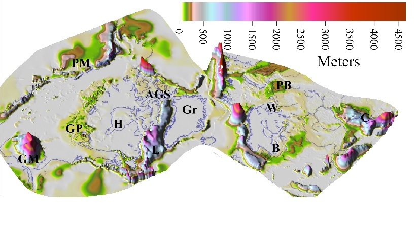
Fig. 1. Dominantly Pleistocene-Holocene accumulation.
Compiled by A. Amantov (1989, VSEGEI Report) from numerous published sources. PM-Pacific Margin, GP-Great Plains, GM-Gulf of Mexico, H-Hudson Bay, AGS-Arctic Gulfs and Sounds, Gr-Greenland, B-Baltic Sea, W-White Sea, PB-Petschora Basin, C-Caspian Sea.
Models of the basal sub-ice temperature based on relevant models for Greenland and Antarctic ice sheets were used to estimate possible zonation and variability of warming effects of ice sheets [4]. Special additional grids, with relevant information (like showing geologically proved frozen-bed conditions) were used as additional input.
Moving back in time, eroded volumes were put back, with restoration of topography and drainage pattern over time. Special analysis was addressed to overdeepenings of different order, which are widespread in glaciated areas. They were estimated using landscape grid filtering with changing rectangular sub-array of nodes. However, correct topography restoration is impossible without determination of isostatic changes caused by redistribution of sediments, ice and water.
The isostatic response to deglaciation was modeled using an Earth model with a layered mantle viscosity overlain by an elastic lithosphere. Different values of flexural rigidity and asthenosphere viscosity were checked to get a best fit between theoretical and observed present rate of uplift and tilting of paleoshorelines. The best fit was achieved with a low-viscosity asthenosphere of thickness less than 150 km and viscosity less than 7.0x10^19 Pa s above a uniform mantle of viscosity 10^21 Pa s, and an effective elastic lithosphere thickness (te) of 30-40 km (flexural rigidity less than 10^24 Nm).
III. RESULTS AND DISCUSSION
Glaciations in time
The continental part of the North Atlantic segment with adjacent shelf regions was repeatedly covered with a continental ice sheet, at least since Gelasian. However the patterns and extents of the early glaciations are very disputable. In contrary to common opinion on the relatively local ice sheets, we believe that extensive Gelasian glaciations are likely. The first 2.4 Ma recorded advance of the Laurentide Ice Sheet reached 39°N near the extreme southern limit of North American glaciation [8]. Far-reaching glaciation of comparable age, covering the Barents Sea and Fennoscandia, was expected in paleogeographical reconstructions of possible pro-glacial lakes close to Caspian depression with rare possible indications of such ice sheet [9]. We assume such option in the modeling. However, specific features are reasonable at the beginning of the ice age. Specific ice base conditions are expected, because of broad distribution of saprolites or weathering crusts. They could cause relatively thin fast-moving ice, with short-term exception in areas of extensive discontinuous permafrost.
More distinct radial glacial erosion pattern and larger basal ice velocities seem likely at the beginning of the early ice-age stage, with partial widening of pre-glacial drainage elements. Intensive cryo-hydration weathering, solifluction or gelifluction at slopes, and intensive (coastal retreat rates up to 1 m/year and more) thermal abrasion are expected in areas without direct glacial influence because of general climatic changes. Wide - originated from Cenozoic stages -lowlands with meandering rivers (often in permafrost conditions) could provoke early stage onset of ice-streams, but only in favorable conditions. Over time, further complication of the pattern from radial to "spider web" is expected due to gradual developing of topographic ice-streams. It is also worth mentioning progressive exhumation of resistant formations, additional complications of the pattern by fluvioglacial activity and glacial sedimentation, "pendulum" principle, with increasing amount of glacial and interglacial sedimentation in eroded material [7].
Approximated variable permafrost distribution seems to be an additional weighty aspect, changing erosion rates during some time intervals. This contributed to differentiation of erosion with heights, because thick continuous permafrost could be developed on relative highlands without protection of large water bodies that did not freeze to the bottom, keeping “warming effect”. Such effect was dependent on eustatic changes and outlines of continental shelf and inner basins, in spite of known possibility of thin permafrost occurrence in cold Arctic seas in restricted height intervals. During onset of glaciation, permafrost-free areas could be subject to faster ice flow and increased erosion. Vice versa, lowlands bearing major topographic ice streams were likely represented by taliks not affected by continuous permafrost or - depending on scenarios and parameters - were shortly affected by reduced permafrost with thick active layer. So, zones were likely stable in space. Also, linear taliks of discontinuous permafrost zone on terrigenous sediments could contribute tunnel valley formation.
Accumulation
In areas that underwent strong ice sheet activity, the upper regional unconformity represents bedrock surface, sculptured by different erosion agents. Their role is often debated [7], but volumes of deposits unquestionably show huge sediment redistribution during ice age. The bedrock is usually covered by the Pleistocene and Holocene sediments, with non-uniform thickness ranging from 0 to 400 m and even more in continental part, but the offshore sedimentation on the continental slope and ocean bottom is known to be an order larger [10, 11]. Such zones of accumulation bound zones of variable erosion and weak deposition, exhibiting general concentric arrangement of glacial activity. However, it usually shows concentric pattern either from the last glacial dome, or from the most active and stable one. It could also differ from the pattern of older or weaker ice sheets, not indicating fluctuations of the position. In parts, resulting zone of accumulation (Fig. 1) covers zone of deep erosion, which was formed mainly by early and/or largest ice sheets. Zone of accumulation in platform domains of Europe extends from Poland and Buelorussia to Petschora basin of the Arctic region (Fig. 1). The average thickness here is more than 50 m, often exceeding 100 –150 m, while the section commonly belongs to several glaciations [12, 13]. Similarly, on the opposite side of Atlantic, sedimentary record of the great western plains of Canada shows that the Laurentide glaciers advanced across the plains at least five times [14, 15]. From southern New York and Ontario westward over the Mississippi valley, west and northwest of the Appalachian Escarpment on the great western plains of Canada, thickness exceeds an average of 25 - 35 m over wide areas, up to 150 – 200 m and more in numerous places [16, 17, 18]. Large areas in the southern peninsula of Michigan, western and southwestern Minnesota, eastern Dakota, western Iowa, and the Great Bear Plain are underlain by more than 70 m of glacial sediment. The pattern of distribution of accumulated material and thickness changes looks very similar to the European one, but some differences could be mentioned. Mostly they are connected with the development of active Cordillera mountain belt, providing its own distinct ice sources of montane glacier, local ice caps, sometime joining into Cordilleran Ice Sheet. It affected onshore accumulating belt from western directions. Everywhere on a soft sedimentary cover deeply incised valleys are common as newly created forms or as modifications of preglacial and interglacial valleys by glacial and fluvio-glacial erosion. They are partly filled with stratified glacial (often representing several glaciations) and Holocene sediments, commonly more than 60 - 100 m thick.
The above-mentioned zones of platform accumulation are only a small part, indicating glacial erosion because of transportation of suspension material into the main peripheral sedimentary basins and on adjacent ocean slope. Large sedimentary fans with definite glacier derived input are well known around Barents Sea continental margins and Norwegian shelf [19, 20]. In Europe main arteries of such transfer of sediments are: Baltic and Kama - Volga marginal (in relation to the glacial boundaries) paths, Dnieper and Don radial conduits [21].
In North America several equivalents exist. The eastern branch of sediment delivery from the central areas of major ice sheets was along the Hudson Bay path - through Hudson Strait with Ungava Bay into the Labrador Sea. Sediment supply results in thick Plio-Pleistocene sedimentary section of the Labrador Sea totaling hundreds of meters [22, 23]. The Arctic Junction Arteries include system of Arctic gulfs and sounds. Radial troughs of Gulf of Boothia with Prince Regent Inlet as well as Mc-Clintoc Channel and Peel Sound combined with crossing marginal system McClure Strait –Viscount Melville Sound to Lancaster Sound. This system of glacial avenues with imprint of deep glacial scour rather than fluvial erosion [24] redistributed ice-rafted debris sourced from northern part of the Hudson Bay Lowland and adjacent part of Canadian Shield in opposite directions from approximate divide at longitude of Boothia peninsula. Lancaster Sound was a path of sediment delivery to the east into trough-mouse fan of Baffin Bay [25]. Alternate destination was Arctic Ocean via McClure Strait.
The Mackenzie Path followed marginal bedrock lowland between the Canadian Shield and sedimentary cover in Lake Athabasca, Great Slave Lake, Great Bear Lake sector with approximate length of around 4 000 km. It transported eroded material from the western part of the Canadian Shield and Rocky Mountains into the Beaufort Sea. As a result oceanward prograding sequences of large delta complex have been deposited, thickening from zero edge on the landward side to over 4000 m in the north Beaufort Sea [26].
The Mississippi Path transferred and redistributed material from the sector between Appalachian Mountains and Rocky Mountains into the Gulf of Mexico as an excellent example of glacial reorganization [11]. It also captured part of material from the Mississippi Path around Great Lakes (especially Lakes Huron – Erie – Ontario segment).
Pacific margin is known to be complicated, with intensive linked tectonic and denudation processes producing large amount of sediments. It also shows large-distance transportation of debris using sophisticated sediment-transport conduits to distal fans and abyssal plains. Such redistribution seems to be controlled by ocean bottom topography, which is strongly generated by structural influence of ocean ridges, rift valleys and transverse fracture zones [27, 28].
In Greenland glacigenic debris was deposited in the Amundsen Basin of the Arctic Ocean, on the East Greenland continental margin, Baffin and Labrador Seas, with partial redistribution in the Atlantic Ocean by bottom currents [29, 30]. The North Pole fan also developed from a source area at the North Greenland and Canadian Arctic continental margin [31, 32].
As a result voluminous amount of debris has been added into the ocean during ice age, for the Arctic – North Atlantic glaciated segment. It is less consolidated material in comparison with eroded bedrock. The accumulation also caused subsequent isostatic compensation, mostly subsidence of large depocenters (Fig. 2). However, it is important that smaller, but still voluminous amount of Pleistocene – Holocene sediments rests on-shore. For example, its volume in areas around the southern Baltic is comparable with large part of supposed erosion of this entire lowland. Onshore accumulation belts, changing the topography and drainage pattern, could also contribute to creation of «water storages».
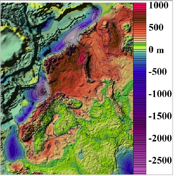
Fig. 2. Calculated isostatic response of Pleistocene-Holocene accumulation and erosion in Fennoscandia and adjacent regions.
Erosion
Glacial erosion is a significant, but variable factor. In particular – as one of the well-known and most recognizable features - it creates numerous overdeepenings of different scale in favorable conditions (Fig. 3), especially in zones of ice streams with reduction of the angle of the base. It is common to different landform types of variable scale, like glacial corries (cirques), lowlands in fjords [33], or just isolated basins of different size. In many cases glacial erosion deepened such areas hundreds meters below the drainage thresholds and “normal” non-excavated thalweg heights. Many huge enclosed basins - including the Baltic Sea - were created or strongly modified by this process. In counting the water-balance we are mostly interested in possible changing of water storage in continental parts. In relation to the ice age onset they hold additional amount of water in inner lakes and seas. In case of huge first-order overdeepenings, the related isostatic uplift often reduces its volume. Only extensive erosion zones - like the Baltic – White Sea lowland - have distinct relevant isostatic rebound component, in opposite to local overdeepenings.
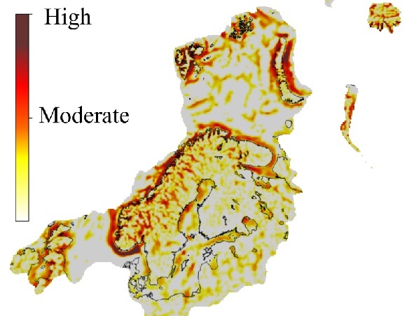
Fig. 3. Largest zones of glacial overdeepenings from automatic landscape analysis.
Water redistribution
Climate factors, with growing and decay of ice sheets and glaciers, contributing to erosion and accumulation are linked with water redistribution on the Earth surface. All processes are tied with isostatic adjustment and overall landscape changes in a sophisticated closed circle. The role of isostasy of water change is larger than many expect. To simplify, we would mention global (ocean) and local (inner seas and prominent lakes) components. Eustatic changes caused isostastic adjustment not only of the ocean bottom, but of the continents, normally with the reversed direction. Since the surface land area is only 29-30%, its “reversed response” could be much larger than the ocean adjustment (e.g. [1]).
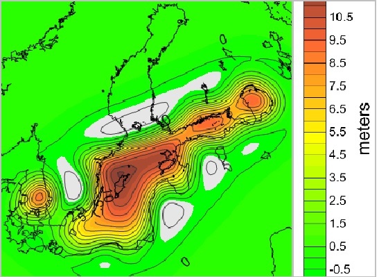
Fig. 4. Modelled hydro-isostatic reaction on the largest final Baltic Ice Lake drop.
Local component is also important to calculate deviations from the “pure” glacial isostatic adjustment. Here we show example of a model of the hydro-isostatic reaction on the final Baltic Ice Lake drop (Fig. 4).
Central zones
It is normally accepted that central zones of the expanded ice sheets were strongly depressed, depending on the ice thickness in areas of ice divide. After the melting they exhibited huge water storage with additional weight. Water volumes have different estimations because of uncertainties of ice models and rheological parameters used by different researchers. In the same way remaining uplift is estimated differently. Our model and the resulting landscape are shown Figure 5.
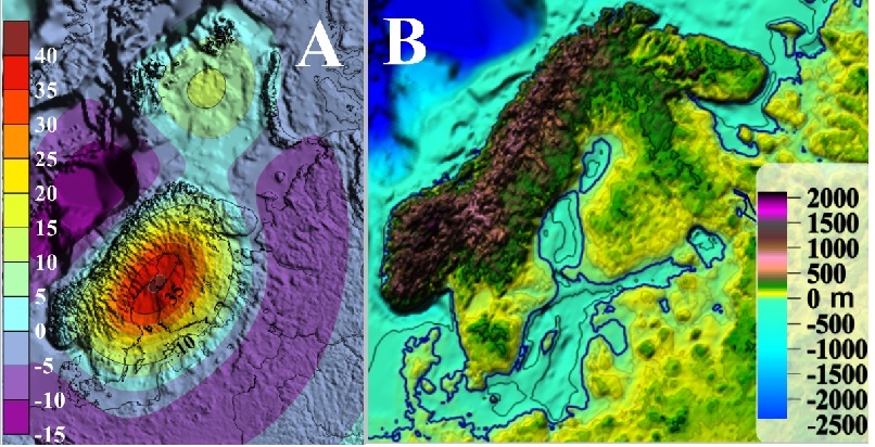
Fig. 5. Remaining isostatic uplift (m) of Fennoscandia from best-fit parameters and one of the ice sheet models (A), and possible landscape changes model, accounting for future uplift, eustatic changes and sediment redistribution (B).
In spite of different history of glacial isostasy, negative topographic elements on pliable sedimentary rocks, previously occupied by central parts of ice sheets (Bothnian Sea, Bothnian Bay, Hudson Bay) would likely remain stable water storage with gradual shallowing up to future system of giant lakes.
IV. CONCLUSIONS
Eustatic changes have interrelations with other long-term processes. These processes are connected with the glacial activity and related isostatic adjustment. Here we focus on gradual topographic changes mostly in glacial and periglacial areas, changing the redistribution of amount of water globally before and after glaciations. In coastal areas they are linked with sediment- and hydro-isostasy.
Glacial erosion is a significant, but variable factor. It creates overdeepenings of different scale in favorable conditions. Many huge enclosed basins - including the Baltic -were created or strongly modified by this process. In relation to the ice age onset they can hold additional amount of water, even if related isostasy often reduces its volume.
Negative topographic elements, previously occupied by central parts of ice sheets (Bothnian, Hudson Bay) would likely remain stable water storage with gradual shallowing up to future system of giant lakes.
Vice versa, accumulation replaces water by low-compacted sediments, with additional subsidence. Large part of deposition was concentrated on positive topographic features.
Hydro-isostasy impacted non-uniform relocation of coastal zone in local and regional scale. The local one is connected with water load changes of the enclosed basins. The regional influence could be subsidence of the ocean floor and subsequent uplift of continents caused by global eustatic changes.
1. W. Fjeldskaar, “Rapid eustatic changes - never globally uniform,” Correlations in Hydrocarbon Exploration. Norwegian Petroleum Society, 1989, pp. 13-19.
2. W. Fjeldskaar, “Geoidal-eustatic changes induced by the deglaciation of Fennoscandia,” Quaternary International, vol. 9, 1991, pp. 1-6.
3. J. I. Svendsen, H. Alexanderson, V.I. Astakhov, I. Demidov, J.A Dowdeswell, S. Funder, V. Gataullin, M. Henriksen, C. Hjort, M. Houmark-Nielsen, H.W. Hubberten, O. Ingolfsson, M. Jakobsson, K.H. Kjaer, E. Larsen, H. Lokrantz, J.P. Lunkka, A. Lysa, J. Mangerud, A. Matiouchkov, A. Murray, P. Moller, F. Niessen, O. Nikolskaya, L. Polyak, M. Saarnisto, C. Siegert, M.J. Siegert, R.F. Spielhagen and R. Stein, “Late Quaternary ice sheet history of northern Eurasia,” Quaternary Science Review, vol. 23, 2004. 1229-1271.
4. A. Amantov and W. Fjeldskaar, “Geological-geomorphological features of the Baltic region and adjacent areas: imprint on glacial-postglacial stages of development,” Regional Geology and Metallogeny, vol. 53, 2013. 90-104.
5. W.R. Peltier, D.F. Argus and R. Drummond, “Space geodesy constrains ice-age terminal deglaciation: The global ICE-6G\C (VM5a) model,” J. Geophys. Res. Solid Earth , vol. 120, 2015, pp. 450-487.
6. A.L.C Hughes, R. Gyllencreutz, Ø.S. Lohne, J. Mangerud and J.I. Svendsen, “The last Eurasian ice sheets - a chronological database and time-slice reconstruction DATED-1,” Boreas, vol. 45, 2016, pp. 1-45.
7. A. Amantov, W. Fjeldskaar and L.M. Cathles, “Glacial erosion of the Baltic Sea region, and the effect on the post-glacial uplift,” In The Baltic Sea Basin. J. Harff, S. Bjorck, and P. Hoth, Eds, Springer, Heidelberg, Chapter 3, 2011, pp. 53-75.
8. G. Balco and C.W. Rovey, “Absolute chronology for major Pleistocene advances of the Laurentide Ice Sheet,” Geology, vol. 38, no. 9, 2010, pp. 795-798.
9. V. Zybakov, “Barents Sea Aktchagyl Hyperglaciation,” Problems of Correlation of Pleistocene Events of the Russian North. Abstracts Vol. SPB, p. 111, December 4-6, 2006.
10. F. Riis and W. Fjeldskaar, “On the magnitude of the Late Tertiary and Quaternary erosion and its significance for the uplift of Scandinavia and the Barents Sea,” In: Larsen, R.M., Brekke, H., Larsen, B.T. and Talleraas, E., Eds: Structural and tectonic modelling and its application to petroleum geology. Norwegian Petroleum Society. Elsevier, 1992, pp. 163-185.
11. W.W. Hay, “Pleistocene-Holocene fluxes are not the earth's norm”. In Material Fluxes on the Surface of the Earth, W.W. Hay and T. Usselmann, Eds., Studies in Geophysics, National Academy Press, 1994, pp. 15-27.
12. J.E. Mojski, “Geology of Poland (Stratigraphy, Quaternary),” Wydawnictwa Geologiczne, Warsaw, 1985, pp. 1-244.
13. A. Gaigalas, “Glacial history of Lithuania,” In Glacial Deposits in North-East Europe, J. Ehlers, S. Kozarski and Ph. Gibbard, Eds., Balkema. Rotterdam, 1995, pp. 127-135.
14. R.W. Klassen, “Quaternary geology of the southern Canadian Interior Plains,” In Quaternary Geology of Canada and Greenland, R.J. Fulton, Ed., Geological Survey of Canada, Geology of Canada, Chapter 2-1, 1989, pp. 138-174.
15. M.M. Fenton, “Quaternary stratigraphy of the Canadian prairies”, In Quaternary Stratigraphy of Canada - A Canadian Contribution to IGCP Project 24. R.J. Fulton (ed.). Geological Survey of Canada, Paper 84-10, 1984, pp. 57-68.
16. D.R. Soller, "Map showing the thickness and character of Quaternary sediments in the glaciated United States east of the Rocky Mountains," U.S.G.S. Bulletin, 1992, 54 p.
17. G. Mossop and I. Shetsen, “Geological Atlas of the Western Canada Sedimentary Basin,” Canadian Society of Petroleum Geologists, Calgary, Alberta, 1994.
18. J.G. Pawlowicz and M.M. Fenton, “Drift thickness of Alberta,” Alberta Geological Survey Map (1:2 000 000 scale), 1995.
19. T.O. Vorren, J.S. Laberg, F. Blaume, J.A. Dowdeswell, N.H. Kenyon, J. Mienert, J. Rumohr and F. Werner, “The Norwegian-Greenland Sea continental margins: morphology and Late Quaternary sedimentary processes and environment,” Quat. Sci. Rev., vol. 17, 1998, pp. 273-302.
20. J.A., Dowdeswell and A. Elverhøi, “The timing of initiation of fast-flowing ice streams during a glacial cycle inferred from glacimarine sedimentation”. Marine Geology, vol. 188, 2002, pp. 3-14.
21. A. Amantov, “Plio-Pleistocene erosion of Fennoscandia and its implication for the Baltic Area,” PPIG CXLIX, Proceedings of the 3rd Marine Geological Conference “The Baltic”, Warszawa, 1995, pp 47-56.
22. D.J.W. Piper and R.A. Myers, “Deep water sediments I, Labrador sea, Acoustic interpretation, Mid - Pliocene to Basal Pleistocene,” In Labrador sea/Mer du Labrador. East Coast Basin Atlas Series. Geological Survey Of Canada, J.S. Bell, R.D. Howie, N. J. McMillan, C.M. Hawkins, and J.L. Bates, Eds., 1989, pp. 18-19.
23. H.W. Josenhans and J. Zevenhuizen, “Quaternary Geology IV, Labrador sea, Isopach and surface texture,” In Labrador sea/Mer du Labrador. East Coast Basin Atlas Series. Geological Survey Of Canada, J.S. Bell, R.D. Howie, N. J. McMillan, C.M. Hawkins, and J.L. Bates, Eds., 1989, pp. 14-15.
24. W.A. White, “More on deep glacial erosion by continental ice sheets and their tongues of distributary ice,” Quaternary Research, vol. 30, 1988, pp. 137-150.
25. A. E. Aksu and D.J.W Piper, “Late Quaternary sedimentation in Baffin Bay,” Can. J. Earth Sci., vol. 24, 1987, pp. 1833-1846.
26. J. Dixon, J.R. Dietrich and D.H. McNeil, “Upper Cretaceous to Pleistocene sequence stratigraphy of the Beaufort-Mackenzie and Banks Island areas, northwest Canada,” Geol. Surv. Can., Bull., vol. 407, 90 p.
27. G.G. Zuffa, W.R. Normark, F. Serra and C.A., Brunner, “Turbidite megabeds in an oceanic rift valley recording jökulhaups of late Pleistocene glacial lakes of the western United States,” J. Geol., vol. 108, 2000, pp. 253-274.
28. W.R. Normark and J.A. Reid, “Extensive deposits on the Pacific Plate from late Pleistocene North American glacial lake outbursts,” J. Geol., vol. 111, 2003, pp. 617-637.
29. J.A. Dowdeswell, N.H. Kenyon and J.S. Laberg, “The glacier-influenced Scoresby Sund Fan, East Greenland continental margin: evidence from GLORIA and 3.5kHz records,” Marine Geology, vol. 143(1-4), 1997, pp. 207-221.
30. C. O´ Cofaigh, J. Taylor, J.A. Dowdeswell and C.J Pudsey, “Palaeo-ice streams, trough mouth fans and high-latitude continental slope sedimentation,” Boreas, Vol. 32, 2003, pp. 37-55.
31. W. Jokat, E. Weigelt, Y. Kristoffersen, T. Rasmussen, T. Schone, “New insights into the evolution of the Lomonosov Ridge and the Eurasia Basin,” Geophys. J. Int. 122, 1995, pp. 378-392.
32. Y. Kristoffersen, M. Sorokin, W. Jokat, O. Svendsen, “A submarine fan in the Amundsen Basin, Arctic Ocean,” Mar. Geol., vol. 204, 2004, pp. 317-324.
33. A. Nesje, “Fjords of Norway: Complex Origin of a Scenic Landscape,” Geomorphological Landscapes of the World, 2010, pp. 223-234.