


Russian Federation
BISAC NAT010000 Ecology
BISAC NAT045050 Ecosystems & Habitats / Coastal Regions & Shorelines
BISAC NAT025000 Ecosystems & Habitats / Oceans & Seas
BISAC NAT045030 Ecosystems & Habitats / Polar Regions
BISAC SCI081000 Earth Sciences / Hydrology
BISAC SCI092000 Global Warming & Climate Change
BISAC SCI020000 Life Sciences / Ecology
BISAC SCI039000 Life Sciences / Marine Biology
BISAC SOC053000 Regional Studies
BISAC TEC060000 Marine & Naval
This work is a multi-disciplinary research aimed to develop common approaches to estimating the current state and forecasting evolution of coastal geosystems. From 2010 to now, the state of coastal zone geosystems of the Crimean and Caucasian Russian coast has been studied. The research tasks are solved using up-to-date IT based integrated analysis of historical and new observational data.
Black Sea, coastal zone, geosystems, sediments, database, natural disasters
I. Introduction
From 2010 to now, specialists of the Southern Branch of Shirshov Institute of Oceanology, Russian Academy of Sciences (SB IO RAS, Gelendzhik) and Marine Hydrophysical Institute (FSBSI MHI since May 2015, Sevastopol) have been conducting joint research of coastal zone geosystems of the Crimean and Caucasian Russian coast. The complex activity aims to work out general approaches to evaluation of the current state and forecast of the evolution of coastal geosystems having regard to variability of natural factors and anthropogenic pressure [1]. The research tasks are solved using up-to-date information technologies based on complex analysis which combined both the acquisition and analysis of new data of the field observations and systematization and analysis of archived data as well as materials of space sounding and aerial photographs. The paper presents results obtained in the course of this work.
II. Research of the coastal zone
Change of the Crimean coastline
From coastal zone geosystem state point of view, changes of the coast and coastal line are essential. In the long term, they occur either because of climatic changes of the sea-level and storm conditions or from human activities. To analyze the coastline changes we used data of contact and satellite observations. Old maps were also applied for the qualitative analysis.
The main natural process affecting coastline change during the last hundred years is the process of the Black Sea level rise, which began in the early 20's of the last century and is still going on. For this period, the relative sea level has risen by 20 centimetres. The main reasons are increase in the positive component of the water balance of the sea due to the rainfall growth and reduced evaporation from the sea surface, and also the tectonic subsidence of the coasts [2]. The storm activity by the Crimean coast, peaking in the middle of the twentieth century, began to decline significantly and reached a low in the end of the century. Since the beginning of the twenty-first century, there has been a tendency to the increase of the storm frequency especially in the western part [3].
The real picture of the development of the coast section under sea level changes is rather complicated and, in general, is not described by unambiguous causal relationships. The decisive role is often played by the rate of the sea level rise.
In the twentieth century, closing bays with bay bars and formation of lagoons (silted estuaries Andreevsky, Donuzlav, Bogayly, etc.) were typical for the Crimean coast. This process was characteristic of the Caspian Sea under the sea level rise conditions, where, along with passive flooding of land, a waterfront bar occurred in the wave breaking band and eventually separated a part of the sea as a lagoon [4]. The process of the insignificant (0.1–0.2 m/year) coastline retreat on the accumulative shores and its alignment (cutting capes and filling coast concavities) is typical for the Western Crimea. The maximum rate of the clay cliffs retreat on the scarp reached 1.5 m/year while its typical value is 0.5 m/year. The process of the spits growth and separation of their distal extremities followed by islands formation (the spits of Tuzla and Bakal) should be noted as well. At present, this process is also characteristic of the Sea of Azov.
However, the most notable changes of the shores were caused by human activities. So, large-scale construction works to protect the Southern and Western coasts of the Crimea were deployed in the second half of the twentieth century. As a result, a considerable stretch of beach was dressed in a concrete frame. The positive results of anthropogenic impact on the coast include reducing the damage caused by landslides; stabilization and abrasion protection of the coastal slope and the adjacent land area with constructions for different purposes and valuable natural landscapes; a significant expansion of the beach areas. However, the construction of protective structures has led to the definite environmental damage – the destruction of coastal marine communities and changes in the conditions of their habitats. As a result, the water area by the Southern Coast of the Crimea lost a number of flora and fauna species, such as: fish-swallow Chromis chromis, perch Serranus scriba, sea cock Eulrigla gurnardus; stone crab Eriphia verrucosa, seahorse Hippocampus guttulatus, etc. The damage caused to the landscape aesthetics seems to be also important. The concrete shores stretching for many kilometers undoubtedly reduce the impression of the unique nature of the Southern Coast.
In contrast to the Southern Coast, the coastal protection strategy turned out to be a failure in the Western Crimea. It was caused both by an unreasonable desire to "improve" the shore with concrete structures and by mechanical transferring the building experience from the Southern Coast to the Western Crimea where the lithodynamic and geomorphologic features of the coastal zone are fundamentally different. As a result, a significant number of coastal protective constructions were destroyed by storms and now represent an emergency area where recreational activities are prohibited (fig.1).
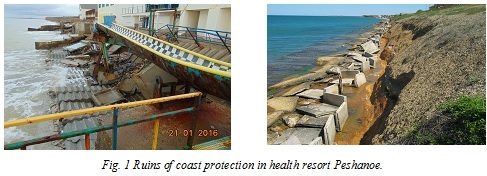
These problem areas are located in the resort areas of Evpatoria, Nikolaevka, Peschanoe, and Beregovoe. The unreasoned construction led to a significant change in the natural dynamics of alongshore streams and to a whole series of negative consequences [5].In general, the essential problem in the Crimean coastal area is a shortage of beach forming material caused by the long-term negative anthropogenic impact and partly by the influence of natural factors.
Anapa bay-bar shoreline dynamics on satellite and aerial photographs
To study the Anapa bay-bar shoreline dynamics, data of aerial survey of 1941 (accomplished by the German AF during the II World War), satellite images of 1960ies (taken within the CORONA program), and satellite images with spatial resolution from 0.5 to 2.0 m for the period since 2003 till now have been used.
For the period of 1941–1966, the washout of the water edge did not exceed 15 m, and during 1941–2013 its average exceeded 37 m. The high accumulation values to the South of the current mouth of the Anapka river during 1941-1966 are probably explained by technogenic displacement of the mouth to the north in early 1960ies. A similar comparison of occasional surveys on 21.08.1966 and 21.11.2013 showed that the washout predominated on the most part of the bay-bar (more than 70 m at certain sections) but the accumulation (more than 20 m) was also observed. For the entire region, mean displacement of the water edge over 47 years was 23.3 m (towards the coast). To precise the results, the data were averaged for the water edge position in 1964–1966 (3 surveys) and 2012–2015 (7 surveys). The mean for the entire bay-bar displacement of the water edge was 22.1 m (towards the coast) for about 50 years, and the maximum washout exceeded 80 m. This value is evidently out of limits of possible errors, so one can speak about the recession of the Anapa bay-bar sea shore. The sections with significantly different washout-accumulation regimes were found out within the Anapa bay-bar [6, 7].
A method for operational registration of sandy coast washouts
A method for operational registration of sandy coast washouts was worked out and tested using the satellite position control system manufactured by “LeicaGeosystems”. It included two dual-frequency receivers (Leica GS10 and Leica GS15) processing signals from navigation satellites GPS (L1,L2), GLONASS (L1,L2), a receiving antenna and a field controller Leica CS 10 to control survey regimes and parameters. The system operation was supported by LeicaSmartWorxViva software [8].
Reasoning from the survey conditions and tasks, the system hard- and software configuration corresponded to RTK-cinematic regime and allowed conducting continuous cinematic survey in real time. For the GS15 receiving device functioning as a mobile receiver (RTK-rover), a special construction was prepared to allow locating the device on operator’s shoulders and facilitating his walking about the survey area. To determine an error resulting from the irregularity of operator’s movement, the measurement was done on an even surface.
Taking into account morphological peculiarities of the accumulative coast, an automatic coordinate counting was conducted with 2 m displacement in plan of with 20 cm relative displacement in height. The worked out technique was used to record the shoreline inter-storm dynamics of the accumulative coast in Krasnodar region(Fig. 2). Applying both the technique and the satellite position control system manufactured by “LeicaGeosystems” allowed executing a large scope of work in short time, quickly determining scale and speed of accumulative coast changes resulting from the storm activity, and passing users’ data necessary to prevent washout consequences.
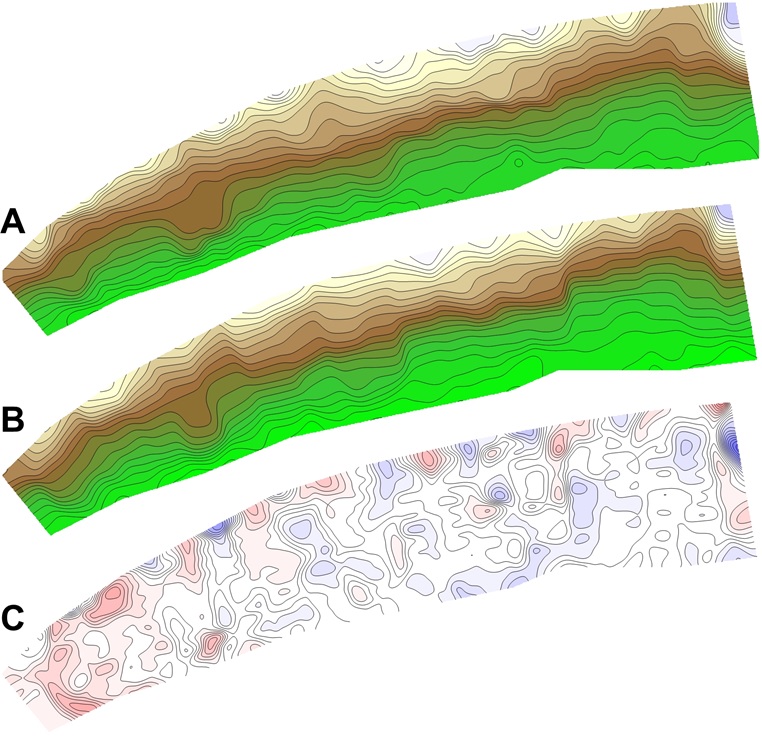
Fig. 2.Beach storm dynamics (A – beach elevation before storm, B – beach elevation after storm, C – change of beach elevation).
III. Study of the ecological status of coastal waters
The Bay of Sevastopol
The Bay of Sevastopol (Fig. 3) is one of rare natural inland harbors at the coast of Crimea on the Black Sea that has being serving as a marine shelter and residence for sequencing human civilizations for over 25 centuries.
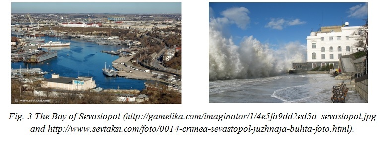
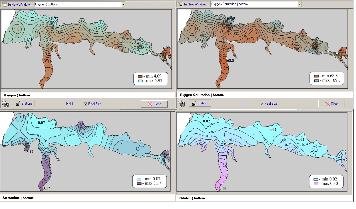
Historically, this bay is a natural reason for the existence of Sevastopol, as a navy base and the city with its all maritime activities. The Bay has been intensively used since Sevastopol was founded in 1783. Currently, Sevastopol Bay is a place for a big and intensively growing seaport (the total length of place for ship docking and mooring is ~11 km), ship docking, sea-land transportation of various goods. The population of Sevastopol is about 400,000 permanent residents, but this number can easily double on summer time. Unfortunately, the major part of municipal and industrial sewage waters (~10,000 m3 per day) are loaded to the bay from ~30 sewers without or after minimal treatment. The latter leads to increase of nutrients and organic carbon supply, supporting active oxygen consumption in the waters of the bay. Biogeochemical conditions in the bay's environment have become so extreme that hypoxia is a regular feature of the inner part of the bay on summer time [9]. Sediments have become sulfidic. To make matter worse, up to 40 µM of sulfide have been registered in the bottom layer of waters. This has drastic negative consequences for the ecosystem of the Bay of Sevastopol.
Yalta Bay
To estimate the ecological state in Yalta Bay including the Yalta port area, the trend of seasonal and interannual variability of data distribution for biogenic elements, oxygen and temperature was studied based on the comparison of data obtained in 1987–2004 and 2005–2010 [10, 11]. Dynamics of biogenic elements and dissolved oxygen on the background of variation in temperature, salinity of waters in the surface and near-bottom layers during all the seasons for the last decade (2003–2012) was also evaluated for the Yalta port area. It was found that the oxygen and temperature regimes in the areas under consideration are in antiphase that became particularly evident in 2005–2010. During this period the content of dissolved oxygen in the surface layer was decreasing especially from May to October while the temperature trend was positive for all the seasons. It was shown that the hydrochemical regime in the Yalta port area since 2005 to 2010 was characterized, despite the temperature growth, by decrease in dissolved oxygen , inorganic phosphor and silicon, and significant increase in content of nitrogen salts (particularly, nitrates) when compared to the period of 1987 – 2004. It was ascertained that the anthropogenic pressure effects both dynamics of the biogenic elements and the oxygen regime in the area under investigation, and it is more pronounced in the surface layer than near bottom.
The Heracles peninsula coastal waters
The hydrochemical regime of the Heracles peninsula coastal waters was also studied. This water area is of particular interest because it is indirectly influenced by all of the bays of Sevastopol (Sevastopol, Kruglaya, Streletskaya, Kazachya, Kamyshovaya, and Balaklava) and undergoes a considerable anthropogenic pressure. The main sewer line is located in this area (more than a half of total city discharge) with a diffuser in a distance of 3.3 km from the shore, resulting in a sharp increase of phytoplankton production caused by an intense influx of biogenic matter and dissolved organics.
The accomplished analysis allowed evaluating the long-term variability in the surface and near-bottom layers for the following hydrochemical parameters: oxygen O2 (ml/l); pH; nitrites NO2 (mkM/l); nitrates NO3 (mkM/l); phosphates PO4 (mkM/l); silicon SiO3 (mkM/l). At the same time, high silicon concentrations (80–167 mkM/l), regardless of the season, were found out especially in the near-bottom layer, and they were observed on the background of low salinity in the surface layer particularly in May and August. As a result of analyzing the annual course of the biogenic elements (phosphor and nitrogen), different from silicon seasonal variability was found, demonstrating evident dependence on biological processes (growth in winter and decrease in summer). At the same time, the research showed insufficiency of data on the Heracles peninsular coastal waters. It raises a question of necessity of continuous hydrochemical monitoring of the area. The priority should be paid to observing distribution of nitrates and ammonium during all the seasons as they are main pollutants in sewer and rainy flows.
IV. Biological studies of the coastal systems
It was found that biogenic carbonates comprise up to 90% of beach sand of Anapa Bay Bar. The main source of carbonates are dead shells of the bivalve Chamelea gallina, inhabiting mostly the depth range 5-10 m. Preliminary investigations of the sediment balance of Anapa bay bar and adjacent regions were conducted, and approximate annual income of the carbonates of biogenic origin was estimated as 350 kg/m2 [12] .
A biological assessment of the sea water pollution was conducted using the gastropod Rapana venosa. In two sites: Sevastopol Bay in Crimea and Blue Bay (2) in the Caucasian coast, imposex females of this whelk were found (see Table 1). Imposex is a phenomenon described for more than 150 gastropod species, when females develop male organs (penises, distal parts of the seminal duct and prostate gland) as a result of interaction with a pesticide tributyltin, a component of antifouling paints for marine vessels and immersed constructions. All imposex females of the rapa whelk examined were Stage 1, rarely 2 on the VDS scale [13], and were expected to function normally in reproduction. It is interesting that imposex females in the small Blue Bay were only found under the pier with moored ships, while samples from the center of the bay (three sites about 200 m apart from each other, with about 300 specimens studied) were lacking imposex. No imposex was found in other investigated sites (ten sites from Sochi to Balaklava Bay, with total more than 1200 specimens analyzed). The presence of imposex in the two bays may be connected with higher shipping activity in these water areas and as a consequence, pollution with tributyltin.
Table 1. Sex distribution of Rapana venosa from sites with detected imposex
|
Sampling site and date |
Males |
Normal females |
Imposex females |
|||
|
Number |
Rw/Tw, % |
Number |
Rw/Tw, % |
Number |
Rw/Tw, % |
|
|
Pier in Blue Bay. June 2010 |
10 |
19.3 |
21 |
27.7 |
0 |
- |
|
Pier in Blue Bay, 16.05.2011 |
6 |
29.2 |
30 |
28.6 |
6 (50%) |
30.0 |
|
Pier in Blue Bay, 27.06.2012 |
1 |
? |
9 |
29 |
10 (91%) |
27.6 |
|
Sevastopol Bay, June 2009 |
1 |
? |
28 |
19.9 |
14 (33%) |
18.9 |
|
Sevastopol Bay, June 2011 |
1 |
? |
1 |
? |
2 (66%) |
? |
|
? – insufficient data. |
||||||
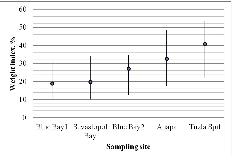
In collaboration with HCMR, Greece, the pollution assessment of Rapana venosa collected in Blue Bay (a region, suffering from high recreational pressure during summer time, with flowing mountain river releasing large volumes of sediments from land) and the Tuzla Spit (a reserve and protected area) using biomarkers acetylcholinesterase (AChE), catalase (CAT), glutathione S-transferase (GST) and metallothionein (MT) was conducted [14]. A several times higher concentration of MT in R.venosa from Blue Bay was shown (Table 2). This, together with the data on imposex, may indicate heavy metals pollution of the bay. Weight indices of rapa whelks from the sites under discussion also indicate much better condition of the population from the Tuzla Spit than those from Sevastopol and Blue Bays (Fig. 4).
Table 2. Biomarkers concentrations in Rapana venosa from Tuzla Spit and Blue Bay
|
Sampling site |
CAT(Units/mg proteins) |
AChE Units/mg proteins) |
GST (nmoles/min/mg proteins) |
MT(mg/g tissue) |
|
Tuzla Spit |
3.73 ±0.21 |
289.81 ±73.00 |
320.28 ±36.93 |
83.53 ±8.12 |
|
Blue Bay2 |
2.38 ±0.30 |
286.24 ±74.09 |
389.11 ±34.56 |
276.33 ±24.28 |
|
|
|
Fig. 4. Weight index of Rapana venosa in the Black Sea (raw weight of the soft body ratio to total raw weight). |
The phenomenon of imposex in R. venosa was described in the Bohai Sea [15] and Chesapeake Bay [16]. In the Black Sea, pseudohermaphrodite females were discovered in Romania [17]. Russia joined the International Convention on the Control of Harmful Anti-fouling Systems on Ships in 2012. The presence of imposex in the Russian Black Sea reveals a necessity of tributyltin pollution monitoring.
V. Databases and GIS
Oceanographic database for information support of the coastal zone study
In the framework of the joint research of coastal zone geosystems of the Crimean peninsula and the Russian Caucasian coast in the Black Sea, a specialized oceanographic database for information support of the coastal zone study has been prepared in the FSBSI MHI oceanographic data bank (MHI BOD). The database includes observations (up to 200 m isobath) along the Crimean and Caucasian coasts as well as on the north-west shelf of the Black sea (fig. 5). The database contains above 97,000 oceanographic and about 19,500 hydrochemical stations (about 20 hydrochemical parameters) and also data on hydrooptics, waves, currents, sea level, and some other parameters [18]. The database served as an information basis while analyzing the environmental state of a number of coastal water areas.
Database and the GIS-type tool for Sevastopol Bay
Sevastopol Bay has become the subject of regular oceanographic investigations and monitoring (regular observations at the regular locations/stations) since 1997. Regular oceanographic studies and monitoring of environmental conditions of the Sevastopol Bay are typically carried out at 32 oceanographic stations at a quarterly basis. Results of monitoring have been contributed to data bases of Marine Hydrophysical Institute of RAS and presented in publications [19]. This has made possible a detailed oceanographic description of Sevastopol Bay. Though these atlases are a valuable source of scientific information, their form has always limited utilization leaving stakeholders and managers with the problems of data accessibility and utilization of data of different nature for integrated coastal zone management. To resolve this problem, a digital atlas [20, 21] has been developed (Fig. 6).
Fig. 5. Distribution of the oceanographic stations
|
|
|
Fig. 6. The digital atlas of Sevastopol Bay. |
There are several tools developed within this system. The major of these tools are GIS (Fig. 7) and indices (Fig.8). The GIS tool is basically an extended set of regular numerical grids for all considered properties that can be arranged as needed (scale of maps, color scheme, isolines and their format) and combined with other layers of information (municipal and industrial buildings, sources of pollutants and their properties, etc.). Though this tool is far more powerful for environmental assessment, it still provides basically scientific information, serving as a basis for calculation of indices [22].
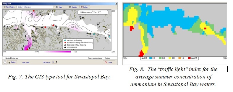
While interaction with gridded data makes possible to construct different maps, which have not been preloaded, indices make possible to evaluate the state of environment and achieve an integrated regional assessment and ICZM. Thus, for example, a "traffic light" index has been constructed and introduced into the system (Fig. 8). As an example, this index has been applied to assess average summer concentrations of ammonium in the surface layer of water. We have used 1-, 3-, 5-, and 10-fold the maximum allowed concentrations for coastal waters used for common purposes. The result clearly demonstrates that only the central part of the bay can be considered as "clean", but the inner part of the bay and that one under heavy municipal and maritime pressures are highly polluted.
Information on indices is generated in the form of tables and various maps and graphs. The most important advantage is that all indexes are calculated "on demand" for needed stations, areas, and periods of time. This makes possible to actually provide an integrated regional assessment, to monitor spatial and temporal variations in the state of coastal environment, to trace negative and positive trends due to changes in anthropogenic pressures or/and climate changes.
Database of the sea shore zone
In the framework of creating an up-to-date database of the sea shore zone current state, a universal data base in the ESRIShape format supposed to be used within a series of projects is concurrently worked out, detailed and corrected. The peninsula coastline location has been corrected so far according to its state in June 2014, including the description of all the coastal objects, particularly dikes, moorings, and retaining walls. An average density of the coastline points is about 6 meters and their general number is 185,000 [23]. At present, the above mentioned database is a basis for developing an interactive information system on the current state of the Crimean coast and also a GIS-tool for operational evaluating the coastal area pollution (Fig. 9).
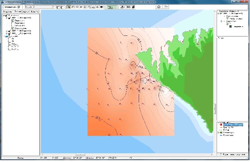
Fig. 9. An example of the database of the sea shore zone information spatial representation
|
|
VI. Natural disasters
Major types of natural catastrophes in the Black Sea coastal zone
Natural disasters in the Black Sea region which took place in the past, are happening in the present and may happen in future, causing death of people, significant economic losses and environmental damage. In the coastal zone of the Crimean peninsula and the Russian Caucasian coast the following natural events are considered the most important in terms of economic and environmental protection:
- abnormal sea level lifting and lowering of meteorological origin (surges, wind fluctuations and anemochore fluctuations of the sea level near the shore);
- gales, caused by Mediterranean cyclones;
- storm surges;
- tsunamis, caused by earthquakes and / or landslides;
- harbor oscillations;
- long-distance propagation of salt water in estuaries;
- abnormal ice conditions and early icing;
- upwelling in the summer period;
- abnormal temperatures and related phenomena (Novorossiysk boron, boron Crimean);
- tornadoes on land and sea, dust storms;
- heavy rains;
- fog over the Black Sea.
To quantify these phenomena, appropriate scientifically based magnitude scales and knowledge of the phenomena intensity thresholds are needed, as their violation may lead to emergency situations. The phenomena's critical magnitudes can be determined when sufficient data of instrumental observations of natural disasters are available. Unfortunately, information about the extreme manifestations of real events for many natural phenomena in the region is relatively scarce; it is limited in time and space. Descriptions of major natural disasters of the past were reflected in ancient books, myths and legends, historical manuscripts, chronicles; they contain little information about the exact quantitative characteristics of the phenomena, so it is not always possible to determine physical causes of their occurrence and physical mechanisms of their development. Thus, continuous work of collecting and organizing data, conducting physic-statistical analysis of historical data, describing hazardous phenomena of different nature, are required. What is more, both types of data are valuable: of the distant past, and obtained in the instrumental observation period.
Insufficient observations severely limit the analysis based on instrumental data about real events. For this reason, mathematical modeling of ocean and atmospheric dynamic processes is currently being developed to study close to real conditions and determine extreme characteristics of hydrometeorological fields in the Black Sea region. To the greatest extent it relates to wind-level fluctuations surges, waves, tsunami, seiches, wind waves, barotropic and baroclinic currents, storm winds, eddies in the atmosphere, and pollutants and sediments transport. There is still much to do and improve in this area of research with the help of modern high-performance computing resources and numerical methods.
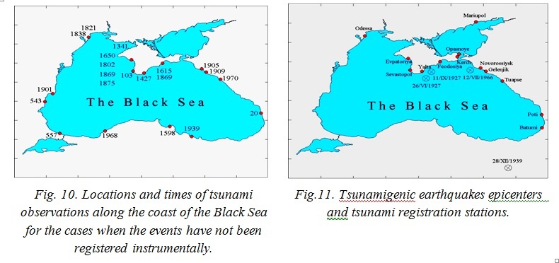
As an example, locations and times of tsunami observation along the coast of the Black Sea are shown (Fig. 10) for the cases when the events have not been registered instrumentally. The case of tsunami registration is shown on Fig. 11.
Research of the effect of an extreme rainfall on the state of the coastal zone
The effect of an extreme rainfall (06.07.2012) on the state of the coastal zone near the city of Gelendzhik was estimated. The abrasion of coast parts by the open sea where solid material entered directly in the surf area, and its immediate wave processing were studied. Numerous landslides have been formed on the sea coast as a resultof this extremely intensive rainfall.
About 20 large landslides of not less than 100 m3 occurred along 2 km line. Colluvium was presented by macrofragmental debris with insignificant amount of fine-grained material. The formation of debris cones (mainly crushed stone) with loam admixture was noticed in the places of narrow valleys joining, in mouths of temporary streams [24]. The extreme rainfall significantly changed the existing “natural” course of the coast evolution. The entered material contributes to a certain increase of beaches and protect the cliff against the impact of small waves. On the other hand, this material will contribute to the cliff base abrasion during heavy storms.
VII. Acknowledgment
The work was financially supported by the Russian Science Foundation (RSF grant 14-50-00095)and study in Sevastopol bay was partially funded by the Russian Foundation for Basic Research (RFBR grant 16-35-60006 mol_a_dk).
1. V. Eremeev, R. Kosyan, M. Krylenko, S. Dotsenko, E. Godin, A. Khaliulin, et al.. “Joint Investigations of the Coastal Zone of Ukraine and Russia in the Black Sea,”Proc. of the Int. Conference MEDCOAST - 2011 (Rhodes, Greece), no. 1, 2011, pp. 71-79.
2. Yu.N. Goryachkin and V.A. Ivanov, The Level of the Black Sea: Past, Present and Future,Sevastopol: EKOSI-Gidrofizika, 2006 [in Russian].
3. Yu.N. Goryachkin and L.N. Repetin, “Storm wind and wave conditions in the Black Sea coast of Crimea,” in Ecological Safety of Coastal and Shelf Zones and Comprehensive Use of Shelf Resources, Sevastopol: EKOSI-Gidrofizika, vol. 19, 2009, pp. 56-69 [in Russian].
4. E.I. Ignatov, Coastal Morfosystems, Moskow-Smolensk: Madzhenta, 2004 [in Russian].
5. Yu.N. Goryachkin, The Modern State of the Coastal Zone of Crimea, Sevastopol: EKOSI-Gidrofizika, 2015[in Russian].
6. M. Krylenko, V. Krylenko, R. Kosyan, “Accumulative coast dynamics estimation by satellite camera records”, Proc. of the Third International Conference on Remote Sensing and Geoinformation of the Environment (RSCY2015), Book Series: Proceedings of SPIE. Vol. 9535. Hadjimitsis, DG; Themistocleous, K; Michaelides,S; et al, 2015. P.95351K. http://dx.doi.org/10.1117/12.2192495.
7. V.V. Krylenko and M.V. Krylenko, “Evaluation of the accumulative edge dynamics using satellitephotographs”,Digests Intern. Conf. “Inter-Karto/InterGIS 21,”Krasnodar, 16-19 November 2015, pp. 439-446 [in Russian].
8. V.V. Krylenko, “Application of GLONASS LEICA GEOSYSTEMS equipment in scientific research”, Geoprofi, vol.5, 2013, pp. 19-23 [in Russian].
9. S.V. Svishchev, S. I. Kondrat’ev, S. K. Konovalov, “Regularities of seasonal variations in the content and distribution of oxygen in waters of the Sevastopol Bay,”Physical Oceanography, vol. 21, no. 4, 2011, pp. 280-293.
10. E.E. Sovga, E.A. Godin, T.V. Plastun, and I.V. Mezentseva, “Evaluation of the hydrochemical regime of the coastal waters in Yalta Bay, ”Marine Hydrophysical Journal, vol. 3, 2014, pp. 48-59, [in Russian].
11. I.V. Mezentseva, E.E. Sovga, E.A. Godin, and T.V. Plastun, “Long-term variability of biogenic elements content in the Yalta port area,” in Ecological Safety of Coastal and Shelf Zones and Comprehensive Use of Shelf Resources, Sevastopol: EKOSI-Gidrofizika, vol. 19, 2013, pp. 255-262 [in Russian].
12. A.R. Kosyan, N.V. Kucheruk, and M.V. Flint, “Role of bivalve mollusks in sediment balance of Anapa bay bar”, Oceanology, vol. 52, no. 1, 2012,pp. 72-78.
13. P. Gibbs, P. Pascoe, and G. Burt, “The use of the dog whelk Nucella lapillus as an indicator of tributyltin (TBT) contamination”, J. Mar. Biol. Assoc. UK, vol. 67, 1987,pp. 507-523.
14. C. Tsangaris, V. Moschino, E. Strogyloudi, V. Coatu, A. Ramšak, A. Kosyan, et al., “Biochemical biomarker responses to pollution in selected sentinel organisms across the Eastern Mediterranean and the Black Sea, ”Environmental Science and Pollution Research, vol. 23, no. 2, 2015, pp. 1789-1804.
15. H.H. Shi, C.J. Huang, S.X. Zhu, X.J. Yu, and W.Y. Xie, “Generalized system of imposex and reproductive failure in female gastropods of coastal waters of mainland China, ”Mar. Ecol. Prog. Ser., vol. 304, 2005,pp. 179-189.
16. R. Mann, J.M. Harding, and E. Westcott, “Occurrence of imposex and seasonal patterns of gametogenesis in the invading veined rapa whelk Rapana venosa from Chesapeake Bay, USA, ”Marine Ecolology Progress Series, no. 310, 2006,pp. 129-138.
17. S. Micu, G. Comanescu, and B. Kelemen, “The imposex status of Rapana venosa population from Agigea littoral,”l. Analele Științifice ale Universității „Al. I. Cuza” Iași, s. Biologie animal,”vol. LV, pp. 133-137.
18. A.Kh. Khaliulin, E.A. Godin, A.V. Ingerov, E.V. Zhuk, L.K. Galkovskaya, E.A. Isaeva,“Ocean data bank of Marine Hydrophysical Institute: information resources to support re-search in the Black sea coastal zone,” in Ecological Safety of Coastal and Shelf Zones of Sea, Sevas-topol: EKOSI-Gidrofizika, vol. 1,2016, pp. 88-94 [in Russian].
19. S.K. Konovalov, A.S. Romanov, O.G. Moiseenko, Yu.L. Vnukov, N.I. Chumakova, E.I.Ovsyany, The Sevastopol Bay Oceanographic Atlas, Sevastopol: EKOSI-Gidrophizika, 2010, 320p.
20. S. Konovalov, V. Vladymyrov, V. Dolotov, A. Sergeeva, Yu. Goryachkin, Yu. Vnukov, et al., “Coastal management tools and databases for Sevastopol Bay (Crimea),”Proc. of the Tenth International Conference on the Mediterranean Coastal Environment (Ed. E. Özhan), MEDCOAST 11, 25-29 October 2011, Rhodes, Greece, MEDCOAST, Mediterranean Coastal Foundation, Dalyan, Muğla, Turkey, 2011, vol. 1, 145-156.
21. S. Konovalov, V.Vladymyrov, V.Dolotov, O. Sergeyeva, Yu. Goryachkin, O. Moiseenko, et al.,“Environmental assessment tools in the PEGASO case - Sevastopol bay, ”Proceedings of the Global Congress on ICM: Lessons Learned to Address New challenges (Ed. E. Özhan), EMECS 10 -MEDCOAST 2013 Joint Conference, 30 Oct - 03 Nov, Marmaris, Turkey, MEDCOAST, Mediterranean Coastal Foundation, Dalyan, Muğla, Turkey, vol. 1, pp. 59-70.
22. O.G. Moiseenko, N.A. Orekhova, A.V. Polyakova, E.V. Medvedev, S.K. Konovalov,“Indices and indicators of the environmental state of the Sebastopol bay,”Moscow University Geography Bulletin,no. 4, 2015, 41-48[in Russian].
23. V.V. Dolotov and A.V. Dolotov, “Conception of constructing a system for monitoring anthropogenic impacts on the sea shore zone, ”Marine Hydrophysical Journal, vol. 6, pp. 34-42, 2015 [in Russian].
24. V.V. Krylenko, M.V. Krylenko, R.D. Kosyan, and I.S. Podymov, “Solid material entering into the coastal zone in the area of Gelendzhik as a result of the extreme shower, ”Oceanology, vol. 54, no. 1, pp. 97-104, 2014 [in Russian].