


BISAC NAT010000 Ecology
BISAC NAT045050 Ecosystems & Habitats / Coastal Regions & Shorelines
BISAC NAT025000 Ecosystems & Habitats / Oceans & Seas
BISAC NAT045030 Ecosystems & Habitats / Polar Regions
BISAC SCI081000 Earth Sciences / Hydrology
BISAC SCI092000 Global Warming & Climate Change
BISAC SCI020000 Life Sciences / Ecology
BISAC SCI039000 Life Sciences / Marine Biology
BISAC SOC053000 Regional Studies
BISAC TEC060000 Marine & Naval
The Anapa bay bar is at present one of only a few sand beaches in the Black Sea coastal zone of Russia. The bay bar includes three main belts – beach, dune belt and hillocky sands. A strong anthropogenic impact is observed: the landscape-morphological structure of the dune belt is disturbed, so monitoring of the bay bar is essential . For this purpose we had compiled a series of maps of landscape-morphological structure for the Blagoveschensk and Vityazevo-Anapa parts of the bay bar using high-resolution images from WorldView-2 satellite. Interpretation of stereo-pairs of multitemporal images was carried out at the scale of 1:2000, while a series of maps was compiled at the scale of 1:5000. Twelve sites with different landscape-morphologic structure are covered by these maps and characterized. The structure depends on geomorphologic neighborhood (adjacency to the cliff or to the lagoon) and aspect to wind direction, but mainly on the degree of anthropogenic influence. So the dune belt has been formed at the beach in some areas, but in other areas the dune belt is located behind the beach, or sometimes has disappeared. The compiled maps clearly reflect these variations and show their mainly anthropogenic origin. These maps will help to investigate adaptive solutions for Anapa bay bar conservation and protection.
bay bar, landscape-morphologic structure, mapping, satellite images, anthropogenic impact
The Anapa bay bar is an accumulative coastal sand feature in the north-western part of the Russian Black Sea coast. It is a unique recreation and balneological area of Russia. In 1996, by a Russian Government Decree, Anapa received the status of a federal resort . There are about 200 medical and health institutions, including those open year-round , dozens of boarding houses and private hotels. The main recreational resources are the Black Sea beaches made of quartz sand and detritus.
A number of natural factors and processes influencing the lithodynamic system of the bay bar promotes coastal retreat and the reduction in the area of beaches. In recent decades, the strongest human pressure has added to the negative effect of environmental factors on ecosystems of the beaches and the dune belt. The joint negative impact of natural and anthropogenic factors leads to the destruction of the bay bar ecosystems, their degradation, and the inevitable loss of a valuable recreational resource [1]. Under these conditions, there is an urgent need to assess the current state of all components of the ecosystem, to study the mechanisms of formation and spatiotemporal variability of accumulative coastal forms, as well as to study the basic processes determining the dynamics of the bay bar.
The Anapa bay bar has long attracted the attention of researchers. Substantial studies of this region has been conducted since the 1940s at the Institute of Oceanology, Russian Academy of Sciences and its Southern Branch [2]. Research results in recent decades have greatly expanded understanding of the evolution, and the modern structure of the lithodynamic system of bay bar and they are summarized in [1]. However, detailed mapping of the bay bar as a necessary basis for monitoring of its changes was not carried out. Since 2012 specialists of the Laboratory of Aerospace Methods in the Department of Cartography and Geoinformatics, Faculty of Geography of the Moscow Lomonosov University and of the Southern Branch of the Institute of Oceanology are engaged in joint research projects focused on mapping and assessment of the current state of the various components of the bay bar ecosystems. They use satellite images and conduct field studies which include interpretation of images and ground spectroradiometry. In this paper we present results of mapping and assessment for parts of Anapa bay bar near Blagoveshchenskaya village, located 20 km north-west of Anapa, and for the southern part of Anapa bay bar between Vityazevo and Anapa settlements – the most important recreational regions of the Anapa resort area.
II. Research area
Anapa bay bar extends from Cape Zhelezny Rog on the Taman peninsula in the north to Cape Anapsky in the south (Fig. 1). It separates Black Sea from a system of lagoons (liman in Russian) and lakes that were once sea bays: Lake Solenoe, Bugazskiy, Kiziltashsky, and Vityazevsky lagoons, Lake Chemburskoe, Anapa marshes. The main feature of the region is the presence of extensive depressions on a flat slightly inclined plain: these are lagoons and marshes, separated by a narrow bay bar from the sea. The bay bar includes three main belts: the beach, the dunes, and hillocky sands. These belts are followed by either a lagoon shore or by a former cliff
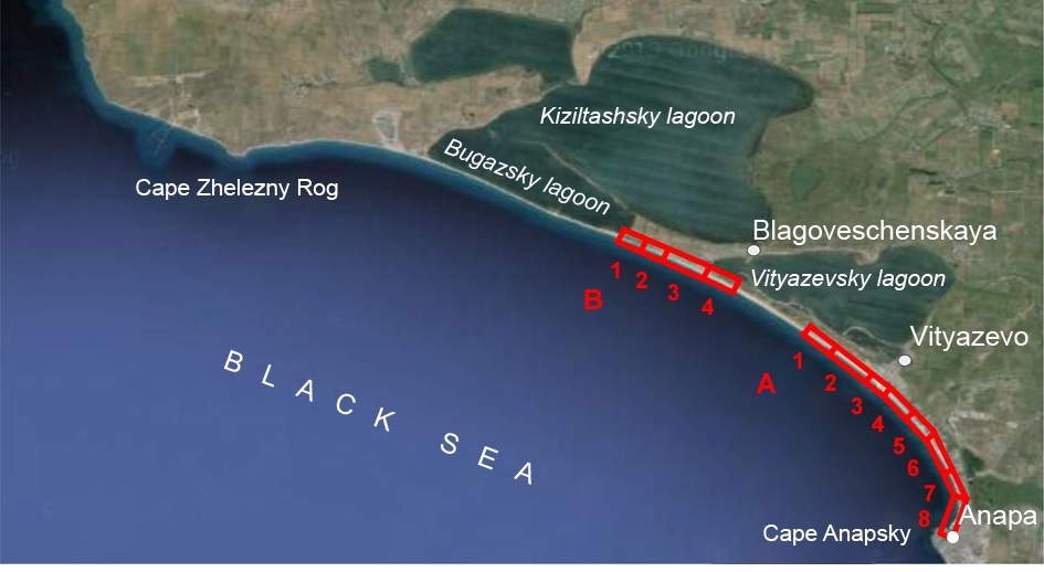
Fig. 1. Location of the study area. Sites of landscape morphological mapping: B-1–4 in Blagoveschensk region; A-1–8 – in Anapa region.
Mapping of the landscape-morphological structure of the bay bar with satellite images is carried out for the two most important recreational areas, Blagoveschensk and Anapa, which differ in natural conditions, and in the degree of development and human impact.
III. Data and methods
Production of a map of the landscape-morphologic structure through visual interpretation of satellite imagery
For mapping we used WorldView-2 satellite images with a resolution of 0.5 m (panchromatic) and 2 m (multispectral) which were merged into a 0.5 m-resolution colour image. We a used colour composite of bands 8-5-1 (near infrared, red, coastal blue) as RGB. In this composite sands display in shades of yellow, and vegetation – in shades of red (Fig. 2).
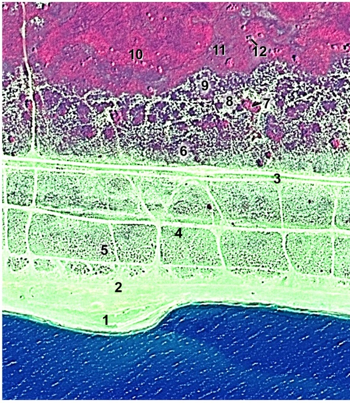
Fig. 2. Excerpt of a WorldView-2 image of the Anapa bay bar. 7 October 2011, bands 8-5-1 as RGB. Numbers are explained in the text
To identify seasonal changes in position of shoreline we used satellite images of August 11 and September 13, 2011. They were taken under different angles (10° and -1° along-track and -5° and 11° across-track, accordingly), therefore we were able to view them stereoscopically, debay bare small color changes caused by seasonal vegetation change [3]. During fieldwork in 2012-2014, we carried out visual interpretation of imagery along field routes, and described landforms, vegetation (including % canopy cover, structure, and species composition). In the lab after the field, in accordance with a pre-designed map legend, we mapped the study area using imagery under a stereoscope. We used image printouts at 1: 2000 scale which is optimal for submeter resolution images, such as WorldView-2, since the resolution of 0.5 m at this scale corresponds to the resolving power of the human eye (0.1-0.2 mm) and to the commonly used accuracy limit of cartographic representation on paper map. We compiled the initial maps at the scale of 1: 2000. Here we present our maps at a smaller scale.
Representation of the mapping objects in satellite imagery
We examine landscape and morphological structure of the land part of the coastal zone along a transverse profile from the sea shore, from bottom level to the top of the dunes and then to the lagoone. It includes the beach, the dune belt, hillocky sands beyond the sand dunes of the ridge, as well as a wide lowland and the coastal zone near the lagoon.
Beach area is very well visible in the images due to maximum brightness, yellowish colour (in the chosen composite) and a relatively smooth homogeneous structure in the areas free from low dunes. We can distinguish a low summer beach (Fig. 2, 1), which is the wave splash zone for low and medium waves and the winter beach (2), which is a splash zone of the most waves during severe storm surges.
Low dunes on beach at different stages of their formation are well visible due to the spotty structure of the image, formed by sagebrush bushes and their shadows: the initial development of beach vegetation (3), beach dunes in the early stages of formation (4), the forming beach dunes with fine hillocky surface (5).
Dune belt stands out in the image through a complex texture combining purple-pink spots of uneven vegetation cover (mainly of sagebrush and searocket) with black spots of dead plants remains and light yellow patches of open sand (6). Deflation basins, formed between the dunes, are vegetated with searocket and shrubs of American silverberry, highlighted in pink (7).
The landward dune which closes the dune belt stands out in the image due to a sparse network of dark purple spots of vegetation on a light background of bare sands (8).
The zone of hillocky sands bordering the landward dunes in the lowland near the lagoon has a peculiar structure in the image, which is a combination of dark purple spots of sagebrush and searocket thickets in depressions with light yellow spots of open sands or rare barley vegetation on higher wavy surfaces (9).
Well vegetated flat lowlands around the lagoon have purple-pink colours in the image. They include lower sand and silty areas occupied by reeds, which are portrayed in a bright pink color (10), and slightly wavy surfaces, often with patches of open sand, which are less densely vegetated by sagebrush and searocket, as well as psammophyte herbs, which have bright purple colour (11). These lowlands are characterized by groups of American silverberry and willow trees (12).
Clear image interpretation keys for most elements of the landscape and morphological structure are present due to variations in vegetation cover. In combination with stereoscopic viewing, this enabled to map the entire set of components of the beach, the dune belt, the hillocky sands and lowlands around the lagoons. Their detailed characteistics were published elsewhere [4] and served as the basis for developing the map legend, which describes them more concisely, omitting the vegetation cover.
The Roman numerals used to number the section headings are optional. Hyphenate complex modifiers: “zero-field-cooled magnetization.” Avoid dangling participles, such as, “Using (1), the potential was calculated.” Write instead, “The potential was calculated using (1),” or “Using (1), we calculated the potential.”
IV. Results and discussion
Twelve maps presented in this paper, which relate to two areas of the bay bar, Blagoveshensk and Anapa, show differences in its landscape and morphological structure resulting from natural and anthropogenic factors.
In the area of the Blagoveschensk outcrop within the four sections of mapping, the bay bar geomorphological environment changes (Fig. 3). In the northwestern part of the region, the cliff comes close to the shore line (section B-1), and then moves away from the coast, leaving room for the development of dune relief on the bay bar (section B-2), and then the bay bar goes along the the depression bordering the western part of Vityazevsky lagoon (sections B-3, B-4).
In the area B-1, which formed a narrow sea terrace under the cliff ledge, conditions for Aeolian transport of sand in the beach area not favorable, only small dunes are formed which adjoin the cliff and are sparsely vegetated by shrubs and clumps of sagebrush. However, on the surface of the outcrop, which towers up by 20 m, a wide (up to 230 m) belt of sand dunes up to 5 m high has formed, with steep windward and leeward slopes and deflation basins between them.
In the area B-2, as soon as the cliff turns to the east, away from the coast, a dune belt appears in the rear of the beach. Its width varies from 50 m in the north-west to 100 m in the southeast of the region. Behind the beach, the coastline dune with flat-topped ridge runs in parallel to the coast; it starts in the north-western part with a height of 1 m and a width of 5-10 m, but then expands to the width of 30 s and reaches a height of 5 m. On the landward side short winding ridges adjoin at an angle of 30 degrees. Their steep windward slopes, like the front ridge, have very sparse (20%) sagebrush vegetation, while the more gentle leeward slopes are covered by sagebrush and searocket thickets, have slightly hillocky terrain and essentially can be attributed to the belt of hillocky sands. Dune belt and hillocky sands are separated from the receding cliff by narrow elongated trough, a kind of near-lagoon depression. The area of B-2 is characterized by intensive anthropogenic influence. Due to the relatively free access to the sea, here the flow of cars is evident, temporary parking lots are formed; the road passages and the dense network of pedestrian walkways to the sea bare the sands and destroy the dune belt.
In the most extensive section B-3, the bay bar is adjacent to the western part of the depression adjoining the Vityazevsky lagoon and occupied by recreational buildings. The beach in this area widens from 50 m in the north-west to 150 m in the south-eastern part. It forms the low beach dune belt which is also expanding from 20 to 70 m. The dunes rise above the beach by 1 m, have a wavy-hillocky surface with terrain amplitudes of 0.5 m, and sparse sagebrush vegetation (10-20%). The dune belt behind the beach zone is very slightly higher ( by 2 m). This is a gentle slope with a weakly defined flat-topped front ridge and winding ridges extending to the rear. Leeward slopes of rear ridges form a fragmented belt of hillocky sands which is fringing Vityazevsky lagoon lowland, covered by holiday camps of Blagoveshensk settlement. Thanks to the organization of special passes to the beach, including bridges over the dunes, dune belt destruction is considerably less than in the section B-2.
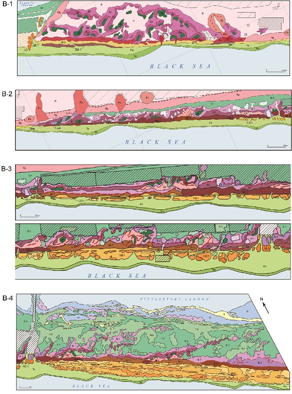
Fig.3. Map of landscape morphological structure
for the Blagoveschensk region of the bay bar
In the section B-4, adjacent to the wide lowland along the Vityazevsky lagoon, and not yet occupied by buildings, conditions are favorable for the free development of Aeolian processes. Wide beach (up to 200 m) is almost entirely occupied by a belt of beach dune 1.5 m high, with a bumpy surface, slightly fixed by sagebrush vegetation (10-20%). Near the main beach of the village of Blagoveshensk this belt is destroyed (only small fragmented ‘islands’ are observed). Behind the beach area the dune belt is rising very slightly (3-4 m). In the north-western part, where no beach dunes are present, the coastal dune is formed by a front ridge, and in the southeast, with well-developed beach dunes, behind the beach there are no ridges, but only gentle dune slopes with sparse (20-40%), sagebrush -searocket vegetation. The transition from the dune belt to near-lagoon lowland is an area of hillocky sands with spotty searocket and grass vegetation with tamarisk (40-60%). The wide (up to 700 m) and flat near-lagoon lowland is covered by grass, sedge and reed vegetation with sparsely growing senjed trees (Elaeagnus angustifolia). Several sand ridges cross this area at oblique angles, possibly an evidence of the ancient history of the bay bar formation.
In the second mapping region of Anapa, between the Vityazevo settlement and Anapa city, the cliff retreats from the shore by 1 km. The area with hillocky sands, as well as the near-lagoon lowland are now fully occupied buildings of Vityazevo, Dzhemete and Anapa, which merged into one populated area. The nature of the dune belt which is sandwiched between the sea and buildings changes within the eight areas of mapping (Fig. 4). The variations of landscape morphological structure are related both to the natural environment, including changes in direction of the coast, and thus exposure to wind, and to a different nature and extent of human impact.
The coast line in the northern part of the region is directed from NW-SE and in the south, curving graduately itchanges in orientation to NS. This change has a significant impact on the development of Aeolian processes. When the south-westerly winds prevail, the angle between the shoreline and the wind direction changes from 90° (in the northern part of the area, sections A-1 to A-4), when the wave action, and the transfer of sand from the beach to the dune belt is the strongest, to 0-20o in the far south of the area where the wind carries the sand along the shore, not towards the rear part of the beach, and as a result there is no sand accumulation and dunes do not form (section A-8).
The influence of natural factors combined with anthropogenic impacts of different types , such as beach recreational use (trampling of the beach surface, creation of access passages to the sea, pedestrian walkways over the dunes), transport recreational use (ATV and motorcycle races), extension of built-up areas into the dune belt, land clearing for construction, placement of spoil heaps during constructionl. It is probably due to the very heavy impact of beach recreation in the area, that despite the significant width of beaches, the dune beach belt is absent.
As a result, in the 12-km stretch of Anapa region, the landscape morphological structure of the bay bar changes. In its northern part (sections A-1 to A-4), due to the wind flow orthogonal to the shore, a high (8-12 m) dune ridge is formed parallel to the shore. It has bumpy windward slopes covered by sagebrush and steep leeward slopes forested by senjed trees and tamarisk. The dune relief is transformed differently in areas with different types of human impact. Near Vityazevo (section A-1) transport and recreational use of large areas of hillocky sands prevails. They are cut through by motorcycle racing tracks. Towards the south, to Dzhemete (sections A-2 to A-4), where areas were built up earlier and are more intensively used for beach recreation, pedestrian walkways over the dunes have great impact. Trampling of the dune surface enhances Aeolian transport of sand, resulting in sand cornices formed on ridges. On the leeward slopes, these cornices collapse and leave sandy trails, which, in some cases, impact fenced recreation areas and residential neighborhoods. In some parts the dune belt is nearing total destruction, and in thre central built-up area of Dzhemete (section A-5) dune belt is destroyed over a kilometer.
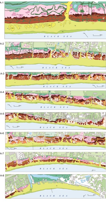
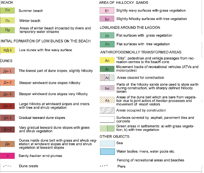
Fig.4. Map of landscape morphological structure for the Anapa region of the bay bar
In the southern part of the region, with different wind conditions and prevalent types of human impact, morphological appearance of the bay bar changes accordingly. If the wind direction is not orthogonal but oblique with respect to the shore, the instead of one large dune ridge, a series of 2-3 small ridges is formed, and they are not always parallel to the shore (sections A-6, A-7). In this part of the bay bar immediately adjacent to Anapa, there isintensive building activity in the dune belt. The construction sites are excavated and flattened in place of dune ridges and depressions between the ridges are used for the storage of spoil heaps of sand/earth. These kinds of human impact prevail here over trampling due to beach recreation activities.
Detailed maps of the landscape-morphological structure of the bay bar compiled in this study should be used in the spatial planning for future development in this region. The currently proposed projects, as shown in [5], are based largely on not only inaccurate, but also misleading information about the bay bar and contain unsubstantiated recommendations that could lead to a deterioration of the recreational attractiveness of the area and to the loss of the unique balneological and recreational resource. Mapping should be the basis of a differentiated approach to the future development of the territory, and should be used in the development of measures to protect and preserve the dune landscapes of the bay bar.
V. Acknowledgment
Fieldwork in 2012-2014, image interpretation and mapping were supported by RFBR projects 13-05-00466A, and 15-05-0265A. Worldview-2 images were provided by Geospatial Challenge contest in 2012 of DigitalGlobe and ERDAS and the contest "Application of satellite images of very high resolution for scientific and educational purposes" of Geoportal of Moscow State University in 2013, with the support of ScanEx and GeoEye.
1. V.V. Krylenko, "Natural and anthropogenic factors determining the evolution of Anapa bay bar", Exec. Summary of the Cand.Sci thesis, Southern branch of the Institute of Oceanology Russian Academy of Sciences, Gelendzhik, 2012, pp. 1-24.
2. V.P. Zenkovich, "Morphology and dynamics of the Soviet Black Sea coast", Izdatelstvo Akademii Nauk SSSR, Moscow, 1, 1958, pp. 1-187.
3. Y.F. Knizhnikov and V.I. Kravtsova, "Deciphering stereoscopic terrain model," Izvestia vyshikh uchebnukh zavedeniy. Geodezia i aerofotos’emka, 2014, 6, pp. 53-58.
4. V.I. Kravtsova, A.A. Falaleeva and E.R. Chalova, "Mapping morphologically contrasting areas of the Blagoveshchenskaya part of the Anapa bay bar with high resolution satellite images," Geodezia i kartografia, 2014, 9, pp. 30-42.
5. Kosyan R.D. Krylenko V.V. Present state and use of the accumulative sea shores in Krasnodar region. Moscow: Nauchny mir. 2014. 256 s.