


BISAC NAT010000 Ecology
BISAC NAT045050 Ecosystems & Habitats / Coastal Regions & Shorelines
BISAC NAT025000 Ecosystems & Habitats / Oceans & Seas
BISAC NAT045030 Ecosystems & Habitats / Polar Regions
BISAC SCI081000 Earth Sciences / Hydrology
BISAC SCI092000 Global Warming & Climate Change
BISAC SCI020000 Life Sciences / Ecology
BISAC SCI039000 Life Sciences / Marine Biology
BISAC SOC053000 Regional Studies
BISAC TEC060000 Marine & Naval
The geologic-geophysical researches including focused on geological dangers in 2015 captured a coastal zone of the southern hollow of Baikal. The methodical basis of these works is made by lake profile and areal surveillance with application of side location, continuous seismoacoustic profiling, a protsezionny ekholotirovaniye, underwater television monitoring, interpretative sampling and reconnoitering coastal monitoring from a board and from the water area. These forms most often represent openings in Baikal seabed with various shapes, depth and width of disclosure. In many cases the central openings or "craters" of these forms are sources of eruption of gas bubbles. Intensity of this eruption changes from minimum to massive in the form of vertical gas streams. On sonar records these forms are represented as black points or lines. Echo sounding presents it as powerful vertical images "columns" which are often going from ground objects to the water surface and defined these forms as "gas griffins". Big attention considering possible geological risks (connected with mass methane saturation of water) payed to larger forms of a ground relief which are conditionally assigned to group of "pockmark".
lake Baikal, coastal zone, geological risks, gas griffins, pockmark
A number of natural and techno genic objective changes recently attract our special attention to dangerous aspects of various processes happening in geological environment.
Existing facts and experiments define two main reasons of the situation.
First of all, global activation of deep (endogenous) and surface (exogenous) geodynamics changes together with other local, regional planetary and extraterrestrial trends causes negative climatic changes.
The changes with all set of meteorological factors imposed on a tectonic background of particular territory essentially affects exogenous geological processes. Most of these processes are destructive.
In the same time anthropogenic factor within the techno sphere very actively and negatively affects the geological environment too. And negative level of these kind of changes usually is even higher than natural destructive processes.
These three main factors or destructions of the geological environment are called geological risks.
Recognized roles of geological risks in processes of vital activity and life support cause special attention of defining the concept, structure and the risk monitoring process. The results are presented in various State standards (GOST). On the first place among these standards is the standard of the dangerous geological phenomena (GOST P 22.0.03).
In general, endogenous geological risks belong to category of so-called natural risks. Since ancient times these risks are subjects of close attention as reasons of local, regional and even global humanitarian shocks.
Due to a number of important factors geological risks have exclusive importance in a transition zone from land to water areas and, first of all, sea and largest fresh-water water areas. From the geological point of view this transitional zone (in the most used name - a coastal zone) represents the uniform multidimensional geo block or a specific element of the geological environment. The geological environment in this case is the most top part of the lithosphere, below a soil layer, including bottom settings, a superficial and buried topography and the top part of a geological section on depth available to mass development (The geological dictionary Part 1 2002).
More than a century numerous researches are devoted to geological risks in coastal zone.
Classical and modern coastal zone researches to some extent paid attention to geological risks. In particular it could be found in publications of the following authors: V. M. Devis's (1909), D. Johnson (1919), P.K.Bozhicha (1930), B.F.Dobrynina (1936,38), V.P. Zenkovich (1946,62), O.K. Longinov (1955, SZ), O.K. of Leontyev (1955, 61), V.P. Budanov (1964), A. S. Ionina (1956, 92), A. A. Aksenova (1972), P.A.Kaplina (1962,73), N. A. Aybulatova (1958, 90, 93), A. A. Zhindareva (1930, 20) and many others [1, 2, 3].
The biggest value from the considered point of view have researches devoted to concrete geological risks in a coastal zone of seas and large lakes.
However, many problems of geological risks remain actual, especially from positions of modern geological representations in methodology, hardware implementation and interpretative variations.
Based on that presenting several latest results concerning geological risks in a coastal zone of such unique geological object as lake Baikal is very valuable. The core of this is the results of the projects started in 2015. The research was based on a complex of geomorphological, geophysical, geochemical and hydrogeological methods during the investigation in the water area of the lake and on its coast (fig. 1, 2).
The research vessels belonging to Limnological institute of the Siberian Branch of the Russian Academy of Science in Irkutsk, and also technical support and specialists of the All-Russian research geological institute of A.P.Karpinskogo (VSEGEI) and Irkutsk national research technical university (Federal State Budgetary Institution VO IRNITU) were involved in the specified projects.
Earlier nature of geological processes and the phenomena in a coastal zone of Baikal was investigated during ashore geological projects, and also at limnological researches in the lake and unique investigation using submersibles (Paysis, Mir) (P.O.Vereshchagina, P.O.Chersky, K.R.Obruchev, E.K.Grechishcheva, V.D. Matsa, P.N.Florepovich, V. V. Lomakina, M. A. Gracheva, N. V. Dumitralko, B.F.Ufimtseva, V.P. Isaeva, V.D. Handulayeva, V.P. Agafonov, G. S. Goldyrev, L. V. Zorin, P.P. Ladokhin, B. F. Loot, N. A. Florensov, N. A. Rimskogo-Korsakov) and others.
.jpg)
The geologic-geophysical researches including focused on geological dangers in 2015 captured a coastal zone of the southern hollow of Baikal.
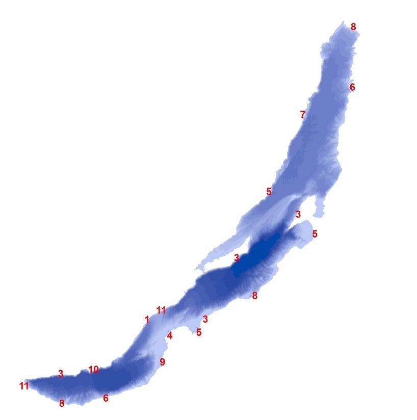
Fig. 2. General type of coastal zone.
The work cover coast and coastal shoal on lake perimeter from Northwest to Southeast around the Selenginsko-Boguldeysky raising, the Boguldeysko-Goloustnensky coastal zone, Listvyank's gulf, a coastal zone from the cape Tolsty to the Slyudyansky gulf, the southern coastal zone Kultukska and Mishikhinska of the deep-water depression connected to Barguzin Range on a site from the gulf Slyudyanka to the mouth of the Selenga River with calling the gulf Proval.
The methodical basis of these works is made by lake profile and areal surveillance with application of side location, continuous seismoacoustic profiling, a protsezionny ekholotirovaniye, underwater television monitoring, interpretative sampling and reconnoitering coastal monitoring from a board and from the water area.
The conducted researches showed and in many cases confirmed earlier taxonomy of a lake coastal zone which includes: - initially dismembered coastal zone
- coast of a tectonic partition with tectonic the transformed underwater coastal slope; ①
- coast of an erosive partition (liman, estariyevy). ②
Initially equal coastal zone
- fault line; ③
The coastal zone created mainly under the influence of not wave processes:
- the deltoid; ④
- alluvial plains; ⑤
- denudation coastal zone. ⑥
The coastal zone created by mainly wave processes:
- abrasion bay; ⑦
- abrasion and accumulative; ⑧
- accumulative lagoon. ⑨
Partially man-caused transformed coastal zone:
- the leveled; ⑩
- bay; ⑪
Endogenous geological risks in a coastal zone of Baikal are caused by primary tectonic partition, active explosive tectonics, and also everywhere shown seismicity.
The tectonic compartmentalization is especially accurately expressed on the western and southwest part of a coastal zone, on contact of the lake with Primorsky Range to the North and the South from a source of the Angara River.
Exclusively narrow lake terrace and foothill loop is replaced by almost steep hillsides (step faults with secondary erosive and tectonic partition).
Especially active manifestations of seismicity in a coastal zone of the lake which is a part of the Baikal rift, created conditions for geodynamic processes with exclusive differentiation and contrast of relief-form processes.
The numerous and frequent centers of earthquakes are grouped in the form of linear zones subparallel to general range of a coastal zone. Earthquakes (2-3 thousand seismic events annually) with the maximum magnitude up to 6 take place.
The seismic event leads to a gap, movement, and also change of high-rise provision of mountain mass of a coastal zone and that is especially dangerous at their lowering. The greatest number of dangerous geological processes of a deep origin are connected with the western part of a coastal zone where the western board of the Baikal rift with a tectonic ledge of Obruchevsky fault is developped, with an amplitude of a relief of a coastal zone of more than 1000-1500m. Sub areal parts of a coastal zone "slope bedlend" widely represented by a congestion of raw fragmental material, taluses and dumps.
Exclusively narrow (no more than hundred meters) the underwater coastal slope breaks by a ledge of "a continental slope" with the steepness to 50 ̊ and more, having a step profile with a longitudinal and faltering partition.
The main geological danger of this part of a coastal zone of the lake consists in rocky taluses and collapses, up to formation of the stone rivers-kurumov which move in space with considerable speeds up to emergence of avalanches. The gravitational factor in this case often provokes avalanches.
In subaqual part of a coastal zone at seismic events there are underwater landslides, sags and mud streams.
Endogenous geological processes could be a reason of tsunami which is one of the main geological risks in the coastal zone of Baikal. This phenomenon has many attestations of eyewitnesses.
In results of a seismic event occurs fast (up to catastrophic) immersion of tectonic blocks of a coastal zone on considerable areas. As an example of it is the largest seismic event of the XIX century (the Uagansky earthquake of 1862). It formed the Gulf Proval (east part of a selenginsky coastal zone) about 300 km ²
On the whole complex of parameters, the similar catastrophic phenomena with a certain share of probability can be predicted for a separate part of a southeast coastal zone of Baikal (near the gulf Slyudyanka and further to the North up to the delta of the Selenga River).
Exogenous geological processes are characterized by big variety with various degree of activity mainly in the southern and southeast part of a coastal zone of the lake, especially on the area from the settlement of Tanghui to the southern flank of the delta of the Selenga River.
One of the most representative exogenous geological risk in a lake coastal zone is "processing of coasts", abrasion processes on an underwater coastal slope, a zanosimost, gravitational, eolovy and erosive processes on coasts.
At existence on Baikal of frequent and strong storms with various orientation of wave fronts in a coastal zone abrasion processes, first of all, actively develop.
Frequent and strong storms with various orientation of wave fronts in a coastal zone of Baikal initiates active abrasion processes.
Due to waves there is a destruction of coast and underwater coastal slopes. In a number of places, the coastline is receded, streams of alongshore and cross movements of sedimentary material are formed.
Thus various forms of coastal (coastal) dynamic accumulation in the form of bars, bay bar and shaft are formed.
Wave abrasion is the reason of natural beaches destruction. It conducts to an intensification of slope processes, stimulates the mud and coastal streams leading to movement of mass of sedimentary material, powerful ground and coastal flood with formation of various forms of dynamic accumulation, ledges, shaft, underwater canyons, the hollows destroying an outer edge of an underwater coastal slope (underwater valleys and gorges in a coastal zone). All this increases the contrast of ground and coastal relief.
Hydrogen component of exogenous geological processes in a coastal zone of the lake including active ice impact on coast and an underwater coastal slope, causes dangerous development of slope processes in the form of landslides, taluses and osov, and also a dangerous drifting of coastal water areas and waterways.
The most part of the specified geological risks is especially peculiar to the most developed southeast site of a coastal zone of the lake and, first of all, to the Trans-Siberian railway area.
The same processes of negative impact affect the coastal zone of the Krugobaykalsky railroad on a part from a source of Angara to the gulf of Slyudyanka (SZ a coastal zone of the lake). It is necessary to emphasize that man-cause impact of various transport, construction, agricultural, mining and other actions on a coastal zone increase emergence of geological risks. In this case negative factors are the undercutting of slopes, removal of mountain masses, vertical bank protection (volnootboyny) walls, berthing facilities, communications, etc.
Dangerous processes of drifting are observed in a southeast coastal zone of Baikal on sites of specific lagoon coast (sorov), and also in estuarial parts of canals of the Selenga River delta.
Fluctuations of the lake level due to actions of Irkutsk hydro technical knot has a great influence on the activation of dangerous exogenous geological processes.
The special and specific type of geological risk in the offshore part of a coastal zone is represented by various types of underwater gas-manifestations.
This geological phenomenon has big distribution in a southeast coastal zone of the lake near the gulf Posolsky sor, Babushkino, the delta of the Selenga River, and also on considerable spaces in other regions of the Baikal coastal zone.
Tens specific forms of a ground micro relief (in dimensions of ten cm) were established on some sites of underwater coastal slope using special GLBO sonar, and special echo sounding.
These forms most often represent openings in Baikal seabed with various shapes, depth and width of disclosure.
In many cases the central openings or "craters" of these forms are sources of eruption of gas bubbles. Intensity of this eruption changes from minimum to massive in the form of vertical gas streams.
On sonar records these forms are represented as black points or lines. Echo sounding presents it as powerful vertical images "columns" which are often going from ground objects to the water surface. The congestion of gas bubbles could be noticed on the surface too where they lead to the effect of "water boiling". V.P. Isaev (IGU) defined these forms as "gas griffins" (fig. 3, 4).
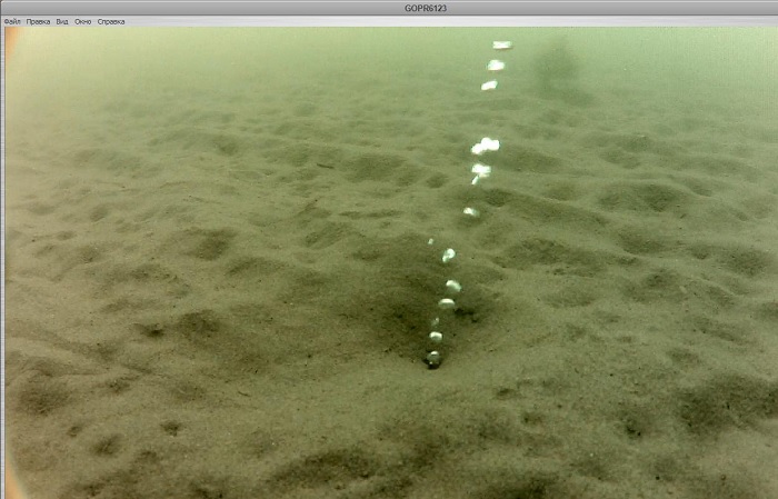
Fig. 3. Typical gas eruption of see bottom.
Big attention considering possible geological risks (connected with mass methane saturation of water) payed to larger forms of a ground relief which are conditionally assigned to group of "pockmark".
According to available data "pockmark" it is a specific form of underwater gas or water-gas mixes eruption.
The form has accurately expressed elements of micro volcanic construction with existence of accurate roundish or oval crater (the oval "caldera") edged by shaft with a congestion of erupted mineral materials. All this is created in the form of a cone with steep external slopes.
It is revealed that "pockmark" due to eruption of high-temperature water-gas mixes leads to melting of powerful Baikal ice with formation of oval ice-holes - "proparin".
Besides dangerous manifestations of these geochemical processes in a coastal zone they create big risk for the transportation which is very common on Baikal on ice.

Fig. 4. 3D model of a gas torch constructed according to multibeam echo sounder.
Provided list of geological risk is peculiar for the southern part of Baikal coastal zone.
In this part of a coastal zone geological risks (endogenous, exogenous and techno genic geodynamics) are the most active and powerful.
The risk is most critical for the southern part of the lake with significant concentration of biological and human activity for which geological environments is one of the main components of environment in general.
In the same time economic, social and ecological activity form other dangerous anthropization problems.
As a result, classification of Baikal coasts in general demands the solution of several of important problems:
- identification of major factors of coast transformations with detection of their regularities and mechanism of actions in time;
- division into regions the most active factors of coast transformations with allocation of zones of increased and high risks;
- the forecast of geological risks in the coastal zone with special attention to studying water areas of the zone (focused within a 50-meter isobar);
- estimates of geological risks in a coastal zone with calculation of geological risk, vulnerability of geological environment and coastal zone damage;
- development of geological bases of costal protection for the purpose of protection of the geological environment and ensuring ecological safety in coastal zone.
As the most effective method of the solution it is necessary to consider the creation and carrying out the State monitoring of the geological environment of the coastal zone of Baikal.
1. Atlas of Lake Baikal. M., RAN, 1976, p. 182.
2. Lut B. F. Geomorphology of lake Baikal // Geomorphology of the Baikal bottom and shores. - M.: Nauka, 1964. - pp. 5-123.
3. Mats V. D., Kulchitsky, A. A. evidences of the newest tectonics in the Baikal rift zone. // Of the Irkutsk geomorphological seminar “Baikal and the mountains around it”, 1994, pp. 23-25.