


BISAC NAT010000 Ecology
BISAC NAT045050 Ecosystems & Habitats / Coastal Regions & Shorelines
BISAC NAT025000 Ecosystems & Habitats / Oceans & Seas
BISAC NAT045030 Ecosystems & Habitats / Polar Regions
BISAC SCI081000 Earth Sciences / Hydrology
BISAC SCI092000 Global Warming & Climate Change
BISAC SCI020000 Life Sciences / Ecology
BISAC SCI039000 Life Sciences / Marine Biology
BISAC SOC053000 Regional Studies
BISAC TEC060000 Marine & Naval
This article presents a study of the geomorphological changes of the Curonian Spit during last century. The analysis was conducted for both geological maps and satellite images. The eastward shift the southern part of the Curonian Spit dune ridge with velocity from 2 to 5 m per year takes place. The comparison of the slopes incline directions with denudation areas was done. In addition, the meteorological parameters affecting aeolian processes on the southeastern Baltic coastal were investigated for the period of 2005-2014. On average, dunes can be dispersed by wind throughout 3617 days in a year. Velocity and direction of the wind, as well as precipitation, are of dominating importance for the dune shift.
Curonian Spit, Grand Dune Ridge, sandy dunes, geomorphological processes, hydrometeolrological regime.
I. INTRODUCTION
The Curonian Spit was included into the UNESCO World Heritage List as a single cultural landscape of shifting and forested dunes of outstanding international importance, which is under constant threat from natural forces [1]. Practically this status was awarded for the human victory over the nature, as the man is responsible for the stop of sand movement. On the other hand, the remained movable dunes are the unique natural objects and represent the main attractive landscape of the Curonian Spit. Among other similar objects, the open (“white”) dunes of Curonian Spit are marked out by their sizes. The Grand Curonian Dune Ridge is the third highest and the second longest shifting coastal dune ridge in Europe [2].
Hydrometeorological conditions (wind regime, precipitation amount, humidity, and air temperature) as well as economical activity (in general recreation) are the most significant factors determinating modern transformation of the Curonian Spit bottom landscape complex.
Aeolian processes are responsible for formation and development of all geomorphological zones of the spit. Stabilization by vegetation of the most part of its area sharply reduced expression of aeolian processes at the accumulative sandy plain and dune ridges. On the other hand, increase of the recreation activity resulted in destruction of the soil-vegetation covering, and, consequently, activation of the aeolian processes at some areas. Today the “white” dunes, especially their slopes, are the most unstable areas. The general geomorphologic trend of the entire Grand Curonian Dune Ridge is the flattening of the highest shifting dunes and the lowering of the average height of the entire shifting dune ridge.
II. GEOLOGICAL AND METEOROLOGICAL SETTING
The Curonian Spit is a young geological formation, developed during Middle and Late Holocene as a result of sediment shift by coastal currents and winds [3, 4]. It presents a typical erosion-accumulative body, originated from the erosion of Sambian Peninsula cliffs and sediments of the Baltic Sea. Location and look, similar to present, the spit assumed about 3-5 thousands years ago in Litorina and PostLitorina stages. The present day parameters of the spit are as follows: total length 98 km, maximal width 4.2 km, and minimal width 0.38 km (Fig. 1). The Grand Dune Ridge was formed 150-200 years ago at the place of ancient parabolic dunes that are covered by thick layer of young sands. Its size varies depending of meteorological conditions: strong western winds contribute the dunes height, whereas eastern winds decrease it.
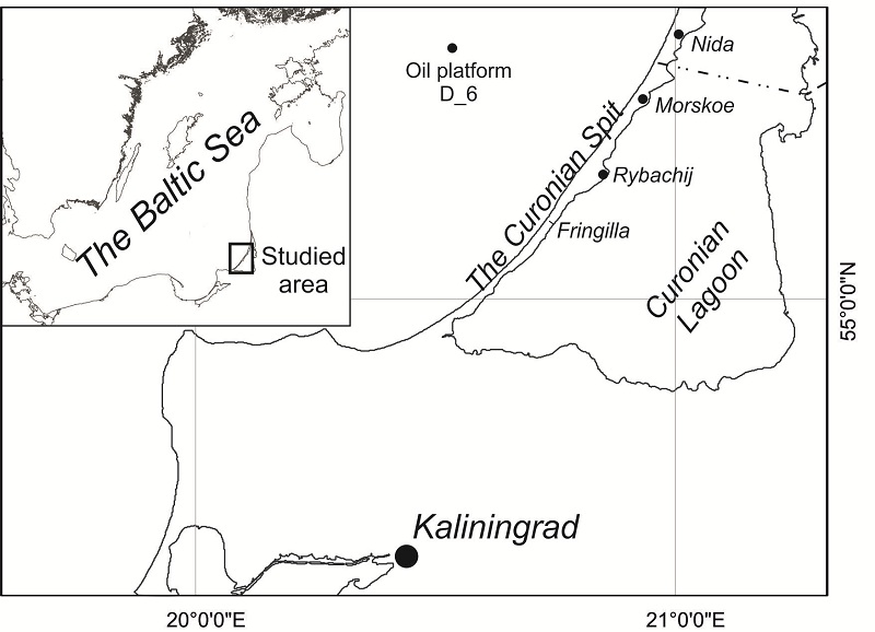
Fig. 1. Location of the studied area.
Shifting barchans are the relict formations. They formed in the period when the vegetation was practically annihilated, and the aeolian processes dominated. Curonian Spit dunes are of typical asymmetric form with steep slopes at the lagoon side and flat slopes sea-directed. Such asymmetric form proves the dune genesis by sand material shift from the seaside by western winds. Existence of different directed cross-bedded layers of sands (Fig. 2) indicates the alternation of sand accumulation with active deflation under wind direction change. Shifting dunes today are moving towards the lagoon somewhere entering the water and eroding [5]. Therefore, the total dune volume decreases.
.jpg)
The studied area is located within the marine climate of temperate latitudes zone. Baric gradient is mostly all-year oriented from the south-east to the north-west. This determines the western winds domination above the Baltic Sea, and the warm and humid air masses transport from the Atlantic Ocean. Therefore, the following features are typical: relatively small fluctuations of the average monthly air temperature, high humidity and cloudiness during the whole year, significant amount of the precipitation, as well as frequent storms.
III. MATERIALS AND METHODS
Satellite images (SI) of low definition (cell size 30-60 m) for the period of 1985-2012 were used for the evaluation of the Curonian Spit dune ridge development. Data processing included an allocation of open and forested areas of dunes by typical optical features of raster image. Dedicated areas were vectorized by ArcGIS.
The comparison of the geological maps (scale 1:25000) of 1910 [6] and detailed SI of 2010 was used for detection of the average ranges of coastline and dune slopes movement. The scanning geological maps were georeferenced to SI using the stable infrastructure object that provides the comparison of the lagoon coastline and sandy dune contours changes with high degree of certainty.
The evaluation of dune surface transformation was done at two areas: southward the Rybachij settlement – Matrosova mt., and close to the Morskoe settlement – Skilvit Dune. For surface transformation analysis were used topographical plans of the 1:5000 scale (surveys of 1983-1984) and shuttle radar topographic mission (SRTM) data of 2000 (the raster resolution of data for this area is 30 m). The comparison of vectorizated topographical data of the maps and SRTM data allowed to evaluate a dune surface transformation. The calculation of the topography deformation thickness was done by the ArcGIS raster calculator tool.
Evaluation of the meteorological parameters influence on the recent dune transformation was based on the data for 2005-2014 from hydrometeorological stations, located on the offshore ice-resistant oil platform D-6, as well as in city of Klaipeda and Nida settlement (www.rp5.ru). The following conditions were taken as a basic for the investigation [7]:
- total precipitation in the period of five days cannot exceed 6 mm;
- average daily air humidity must be less than 95%;
- average daily wind velocity must exceed 6 ms-1, with wind directions within the range of 180–360° (from southern-western-northern rhumbs);
- average daily air temperature must be above 0°C or below –10°C [8].
Relative air humidity, velocity and direction of the wind, as well as air temperature were received from the meteostation, located at the offshore ice resistant platform D-6, at 27 m height. The wind velocity was reduced to standard 10 m. Precipitation was studied by data from meteostation at Nida settlement, located at the lagoon coast of the Curonian Spit (55°19¢N 21°01¢E), the height of the station is 2 m above the sea level. Absent dates were added by data from Klaipeda Hydrometcentre (55°42¢N 21°09¢E).
IV. RESULTS
Geomorphology
The main direction of the movement of dunes is the east along the whole dune ridge. The dunes moved by 300-400 m towards the lagoon for the period of 1910-2010, and by 70-130 m during 1985-2012. Maximum shift was revealed for the open dunes near the Morskoe settlement. Calculation of the movement average range by cartographic data as well as by data of SI analysis revealed similar results. Dune migration range was 3-4 m/year for the century measurement whereas for the last 27 years it was about 2.6-4.8 m/year.
Analysis of the vegetation development on the open dune areas revealed a foresting of the dune western slopes during 1985-2012 (Fig. 3). As a result, the reduction of sandy surface, exposed for winds, takes place. At that, the forested area at the western dune slope prevails over the area of dunes shift eastward towards the lagoon. Thus the tendency of open dune total area reduce is observed. The average annual decrease of the acreage of the shifting sand did not exceed 0.1% during the second half of the 20th century [9].
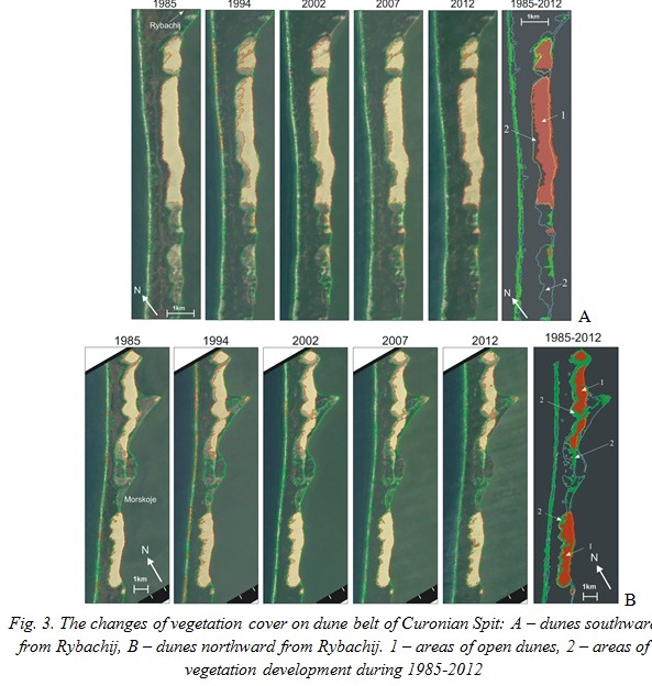
Considerable part of the lagoon coasts of the Curonian Spit is eroded, especially in areas where the material supply from the sandy dunes is absent. Southward and northward from the Rybachij settlement the coast retreats with velocity of 0.5-2.0 m/year. Northward the Morskoe settlement the lagoon coast is most dissected part. On this coast, the washout of the sandy escarp takes place by 1-3 m/year at the southern side, and by 0.5-0.75 m/year at the eastern and northern sides. It is obvious, that the abrasion of dunes comes up also from the Curonian Lagoon waters activity. However, positive trend of dunes movement shows that range of sand supply from the dunes exceeds the washout velocity.
Tendency of active sand loss from the dunes and coastline shift is clearly observed by comparison of large open dunes topography for the 16-years period of 1984-2000 (Fig. 4).
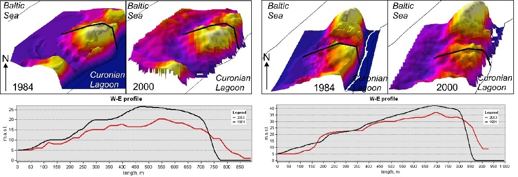
Fig. 4. Cross-section profiles of Matrosova mt. (left figure) and Skilvit mt. (right figure) based on digital elevation model of 1984 and 2000.
The comparison of the topography data, received from different sources, is rather approximate and cannot be used for exact calculations. However it makes possible to evaluate the general tendency and rough volumes of the transported material. Dune surface transformation more often takes place near its top and a leeward side slope. The windward side of the dune root remains virtually without any changes due to surface afforestation and slope stabilization.
The study of the dune located southward the Rybachij settlement (Matrosova mt.) revealed that its surface had shifted down by 5-10 m per 16-years. At the same time the eastern slope had entered the lagoon for 100 m and formed the sandy lens of 10 m thickness. The similar dynamics occurred for the dune located near the Morskoe settlement: the dune top had shifted down by 5-10 m, somewhere up to 15 m; the sandy lens length is about 100 m and thickness about 20 m. The western slope remains without any visible changes.
The comparison of the dune slopes angles and the areas of the maximal dune transformation revealed that the maximal decrease of sand thickness occurred for the western and north-western slopes. The growth took place at the opposite eastern and south-eastern slopes.
Meteorology
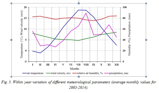
The favorable periods for the intensive generation of the aeolian land forms were marked out within an annual variation. Their features are the following: frequent and strong winds, minor amount of atmospheric precipitation and low air humidity. Analysis of an average monthly meteorological data for 2005-2014 revealed (Fig. 5):
- unfavorable by temperature are January and February, when average monthly temperatures vary from 0 to -10 °С;
- average monthly wind velocities exceed 6 m/s during 7 months (September-March);
- average monthly relative air humidity does not exceed 95 %, so by this value the aeolian forms may develop through the whole year;
- average monthly precipitation sums were minimal in February-April (about 30 mm/month). The precipitation amount increases from June and reaches maximum in August.
Detailed consideration of the average daily meteorological parameters revealed the following results (Table 1).
- Temperature conditions at the Curonian Spit are unfavorable for aeolian forms development 52±38 days per year on average. In 2008 the air temperature promoted the aeolian processes through almost the whole year; minimal amount of days (221) was in 2005.
- Total 10 days per year the annual daily relative air humidity was more than 95 %. This value varied from 330 days in 2011 to 357 days in 2005.
- The Curonian Spit coast refers to the area with domination of the western winds of 5-6 points’ strength by Beaufort scale. The winds with average daily velocity of 6 m/s dominates during half a year (180±10 days). The range varied from 161 days in 2006 to 196 days in 2011. The dominating wind direction varied from 180 to 360° by the wind rose within 219±21 days per year. 242 days with such winds were determined in 2011, whereas only 191 days were in 2014.
- Despite the fact that the South-Eastern Baltic Region regards the area with excess humidity, about 45% (168±30 days) of all days the precipitation does not prevent the aeolian processes development. The most favorable year was 2014 (221 days), the less – 2012 (112 days).
Table 1 – Amount of days favorable for aeolian processes development at the Curonian Spit by different meteorological parameters and totally
|
Year |
Air temperature |
Relative humidity |
Wind velocity |
Wind direction |
Precipitation sum |
Total effect |
|
2005 |
221 |
357 |
190 |
212 |
190 |
35 |
|
2006 |
312 |
355 |
161 |
230 |
189 |
35 |
|
2007 |
337 |
341 |
177 |
240 |
153 |
22 |
|
2008 |
355 |
349 |
178 |
240 |
146 |
29 |
|
2009 |
334 |
350 |
180 |
194 |
153 |
15 |
|
2010 |
278 |
343 |
183 |
194 |
162 |
26 |
|
2011 |
329 |
330 |
196 |
242 |
159 |
40 |
|
2012 |
326 |
350 |
177 |
238 |
112 |
27 |
|
2013 |
306 |
346 |
169 |
209 |
193 |
72 |
|
2014 |
330 |
333 |
189 |
191 |
221 |
58 |
|
av. ±s |
313±38 |
345±9 |
180±10 |
219±21 |
168±31 |
36±17 |
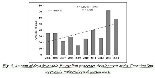
Analysis of the meteorological conditions in the aggregate revealed that the best conditions for the aeolian forms development at the Curonian Spit were in 2013 (72 favorable days). Only 15 such days were in 2009. The dunes were potentially formed by weathering during 36±17 days per year on average for the period of 2005-2014. The upward trend for the period with favorable days for the aeolian dunes forming took place (Fig. 6).
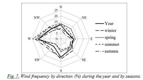
Analysis of different meteorological parameters’ revealed that the most significant influence over the weathering had wind conditions. The Curonian Spit is open for the dominating through the whole year winds of western rhumbs (from SW to NW), which are the strongest ones. The resulting transport vector in the region is directed from the SW to NE (230°), the value of the transport velocity module is 1.8 m/s [10]. The wind direction frequency is shown at the Fig. 7. Within year distribution of the days with wind velocity > 6 m/s- had a seasonal character, maximal amount of the days occurred in autumn-winter period: up to 23.6 days in December. This is confirmed by significant horizontal gradients of the air pressure. Decrease of the amount of the days with winds > 6 m/s begins in February and reaches its minimum in summer, especially in July (~6.5 days). Just in summer the horizontal gradients of the air pressure are the lowest. The increase of the winds > 6 m/s-1 frequency begins in August.
The wind velocity at Curonian Spit depends on its direction. The alongshore wind direction from 180 to 360° (S–W–N) is typical for the most of the days with average velocity > 6 m/s-1, and it assists the aeolian processes development. The spring-summer period is characterized by minimal amount of such days, whereas more than 2/3 of autumn-winter period is favorable for aeolian forms development (Table 2).
Table 2. Number of days with average wind velocity > 6 m/s-1. Means for the period 2005-2014
|
Month |
I |
II |
III |
IV |
V |
VI |
VII |
VIII |
IX |
X |
XI |
XII |
Year |
|
W > 6 m/s |
21.8 |
17.8 |
14.6 |
10.9 |
9.0 |
7.8 |
6.4 |
12 |
14 |
20.3 |
22.1 |
23.6 |
180.3 |
|
(S-N) and >6 m/s |
8.9 |
8.5 |
8.0 |
6.0 |
4.4 |
5.2 |
4.1 |
9.2 |
8.4 |
12.8 |
20.7 |
23.6 |
119.8 |
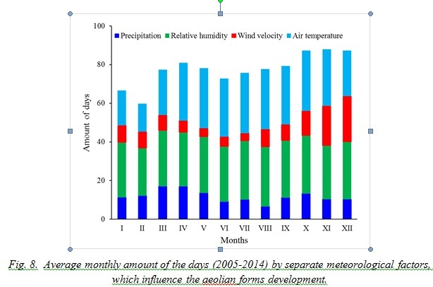
The precipitation regime is a limiting factor. The intensity of downpours increases in the summer and the amount of favorable days decreases up to 6.7 in August (Fig. 8). Maximal average monthly amount of the days was defined in March and April (17 days).
The wind regime and precipitation amount are the main factors affected the forming and development of the dunes. Temperature conditions as well as relative humidity are not the obstacles for studied processes.
Variability of days’ amount within the year is shown at Fig. 9. Maximal amount of days (12) by all parameters totality was defined in November. It is related to fact that in November the maximal velocities of western winds and considerable precipitation occur, and the air temperature rarely is below 0° (Fig. 9). Minimal days’ amount is in the spring-summer period due to wind velocity and precipitation decrease. The amount of days increases in August when the maximal precipitation occurs; in autumn the wind velocity increases.
.jpg)
V. CONCLUSION
Analysis of cartographic materials for the hundred years and satellite images for last decades revealed the eastward shift the southern part of the Curonian Spit dune ridge. The range in both cases is comparable – from 2 to 5 m per year.
An important feature is an existence of relatively reduction of the “white” dune area because of the western slope forestation what provides the common decrease of wind influence over sand transport.
Morphometric analysis of dune topography revealed the tendency to fixation of the western slope, denudation of the top, and partial flattening of the eastern slope with its entrance to the lagoon. Such tendency leads to gradual loss of the sandy material of dune ridge, and consequent decrease of dune migration range.
The comparison of the slopes incline directions with denudation areas revealed the domination of blowing-off from the western and northwestern slopes. Growth is typical for the opposite slopes – eastern and southeastern, what may be explained by prevalence of the western and northwestern winds.
Velocity and direction of the wind, as well as precipitation, are of dominating importance for the dune shift. On average, dunes can be dispersed by wind throughout 36±17 days in a year during the period of 2005-2014. The upward trend for the days with favorable days for the aeolian dunes forming took place.
VI. ACKNOLEDGEMENT
Geomorphological investigations were financed by the Russian Scientific Fund (grant 14-37-00047); analysis of meteorological data was financed by Basic Theme № 01201376666 of the Fundamental Study of Russian Academy of Sciences “Processes of formation and recent changes of the geological conditions in the Baltic Sea and within typical areas of the Atlantic Ocean”.
1. UNESCO, Report on Monitoring Mission to the Curonian Spit (Lithuania / Russian Federation), 16-18 August 2001, ed. Henry Cleere, 2001.
2. R. Povilanskas, H. Baghdasarian, S. Arakelyan, J. Satkūnas, J. Taminskas, “Morphodynamic trends of the Holocene dune ridge on the Curonian Spit (Lithuania/Russia),” J. Coastal Res., vol. 25(1), 2009, pp. 209-215.
3. E.N. Badyukova, L.A. Zhindarev, S.A. Luk’yanova, and G.D. Solov’eva, “Geological Structure of the Curonian Spit (of the Baltic Sea) and Its Evolution History (Revised),” Oceanology, vol. 47, No. 4, 2007, pp. 554-563.
4. A. Sergeev, “The paleogeographic reconstruction of the Curonian Spit area in the Late Pleistocene-Holocene based on new geological data,” Reg. Geol. Metallogeny, vol. 62, 2015, pp.34-44. (In Russian).
5. E.N. Badyukova, L.A. Zhindarev, S.A. Luk’yanova, and G.D. Solov’eva, V.V. Scherbina, “Features of the recent dynamics of the lagoon coasts of the Curonian Spit, Southeastern Baltic,” Lithodynamic of the bottom contact zone of the ocean, Moscow, GEOS, 2009, 168 p.
6. Geologische karte von Preußen und benachbarten bundesstaaten. Ed. H. Heß v. Wichdorff. 1910
7. M. Hojan and M. Więcław, “Influence of meteorological conditions on aeolian processes along the Polish cliff coast,” Baltica, vol. 27 (1), 2014, pp. 63-74.
8. M. Hojan, “Aeolian processes on the cliffs of Wolin Island,” Quaestiones Geographicae, vol. 28A/2, 2009, pp. 39-46.
9. R. Povilanskas, “Spatial diversity of modern geomorphological processes on a Holocene Dune Ridge on the Curonian Spit in the South-East Baltic,” Baltica, vol. 22 (2), 2009, pp. 77-88.
10. V. P. Bobykina and Zh. I. Stont, “Winter storm activity in 2011-2012 and its consequences for the Southeastern Baltic coast,” Water Resour., Pleiades Publishing, Ltd., vol. 42(3), 2015, pp. 371-377.