


BISAC NAT010000 Ecology
BISAC NAT045050 Ecosystems & Habitats / Coastal Regions & Shorelines
BISAC NAT025000 Ecosystems & Habitats / Oceans & Seas
BISAC NAT045030 Ecosystems & Habitats / Polar Regions
BISAC SCI081000 Earth Sciences / Hydrology
BISAC SCI092000 Global Warming & Climate Change
BISAC SCI020000 Life Sciences / Ecology
BISAC SCI039000 Life Sciences / Marine Biology
BISAC SOC053000 Regional Studies
BISAC TEC060000 Marine & Naval
The paper discusses the configuration options of port waters and channels affected by deposition in coastal flow of sediment transport (with/without waves). Performed typing the possible configuration options structures, hydro- and litho-dynamics conditions that lead to reducing the depth of areas and channels. Proposed the engineering method of port areas and channels deposition calculating depending on their configuration, nature and intensity of currents.
port waters, navigation channels, dredging, waves and currents alongshore sediment transport, deposition.
I. Introduction
When designing ports, one of the important tasks is to forecast deposition in port waters and approach channels, sandy or pebbly sediments. On the basis of the forecast are determined the frequency and volume of maintenance dredging works.
In the modern literature largely discussed the deposition of approach channels to ports [1-14] and several lesser the deposition of port areas [15-18].
In all the works it is noted that the deposition of approach occurs as a result of speed reduction of alongshore current over the channel due to the increase of depth and, respectively, reduce the carrying capacity of the water flow. In addition, port facilities solid structures may stop completely or partially of alongshore sediment transport with the formation of accumulative forms. In the number of works [9, 11-14, 17-18] for some configurations of hydraulic structures describes physics of the process. However, the classification (typing) options deposition in port waters and approach channels, as well as the general engineering method of calculation is missing.
II. Classification of structures configurations,
at which there is a deposition of water areas and channels
Deposition in port waters and approach channels occurs for the following reasons:
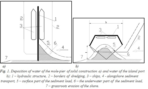
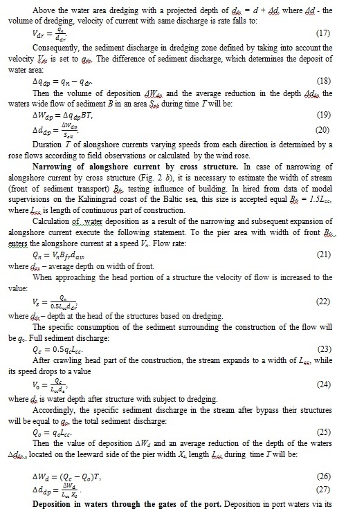
1. The interception completely or partially of alongshore sediment transport by port moles of solid structure with the formation in the waters of the berths of accumulative forms of the type "incoming angle" – Fig. 1, a). In such instances when unidirectional sediment transport may occur grassroots erosion of the shore. In the case of multi-directional sediment transport, incoming angles are formed on both sides of the mole.
2. Unloading of an alongshore sediment transport in a wave shadow of island port with formation of spit – Fig. 1 b). In such cases at the unidirectional alongshore stream of deposits, there is a local washout of the coast. In case of multidirectional streams of deposits, the spit can degenerate in tombolo (connected with breakwater).
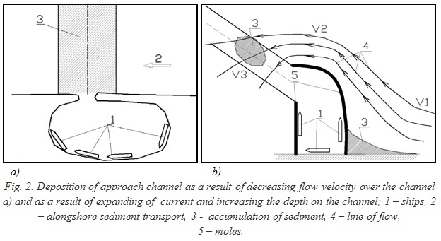
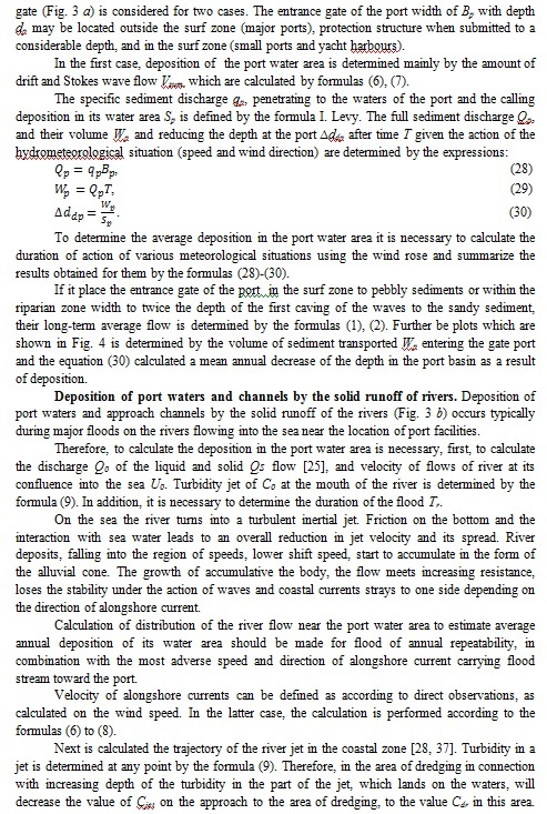
3. Unloading of alongshore sediment transport on the approach channel when reducing the speed of current at the expense of increase in the area of its live section on dredging of the channel – Fig. 2 a).
4. Unloading of an alongshore sediment transport in the water area of dredging or on the approach channel at reduction of speed of an alongshore current as a result of at first its narrowing with increase in speed and, respectively, a stream turbidity, and then its expansion with reduction of speed and loss of deposits. Arises at considerable promotion of protective piers in the sea concerning the line of the coast - Fig. 2 b). Thus additional reduction of current is caused also by increase in depths in dredging zones.
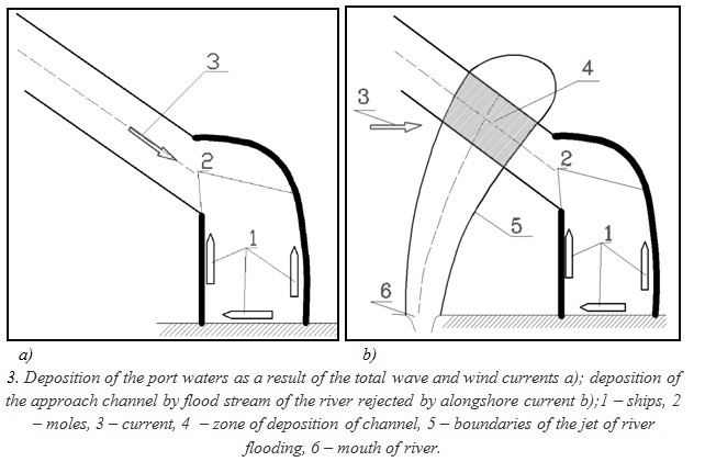
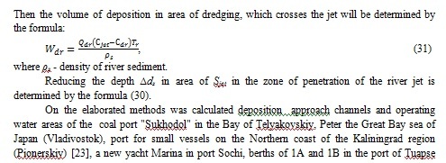
5. Deposition of port water as a result of the ingress of sediment under the influence of wave and wind currents – Fig. 3 a).
6. Deposition of dredging water area, or of the approach channel by sediments of the river flood jet – Fig. 3 b).
It should be noted [23] that the waves and currents have the opposite effect on alongshore sandy sediment transport in the vicinity of cross shore constructions.
Under the influence of slantwise suitable waves sandy sediments tend to form a cross before the construction of the "incoming angle", that is accumulative form. At the grass-roots plot has place grass-roots erosion due to sediment deficit in alongshore current.
At the same time, current is forms of the cycle before the construction, seeking to erode the shore. Skirting the structure with sea side during "tapering" and its speed increases, it becomes saturated with suspended sediment. After bypass construction, the jet of flow expands, its velocity decreases and the sediment fall out in the head part of the structure on the leeward of him. With bottom-side of construction is formed the second cycle, seeking to form an accumulative form.
III. Models of hydro- and litho-dynamics of a coastal zone of the sea
For modeling of port water areas deposition it is necessary to define the settlement equations describing the physical processes given above.
The estimated waves elements in the coastal zone can be determined in accordance with [29, 32].
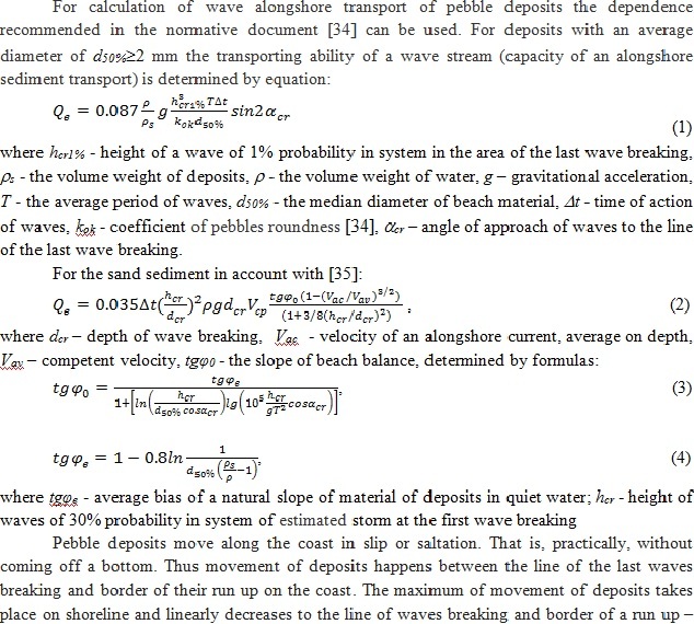
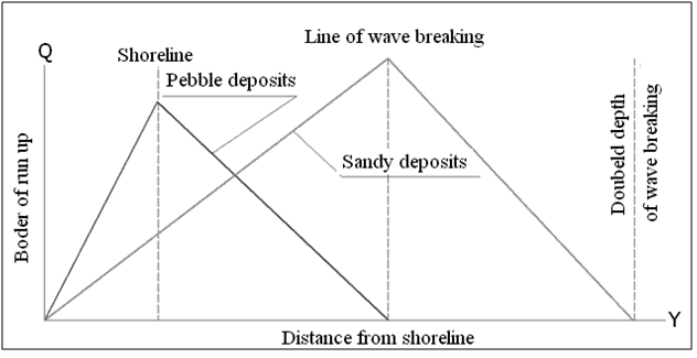
Fig. 4. The schematized diagrams of alongshore transport of pebble and sandy deposits
V. Conclusions
1. Classified configurations of the port waters and approach channels from the point of view of their deposition by sediment wave field or not wave currents.
2. Defined theoretical principles and computational formulas, allowing to estimate the deposition of water area and approach channel of the port having the configuration of structures according to Fig. 1 - 3, or their combinations.
3. Developed engineering calculation methods of deposition of water areas and approach channels.
4. Developed methods were applied for calculations of deposition of water areas and approach channels to a set of ports.
Work performed within the state budget scientific research work № 2614 "Development of mathematical models of interaction between waves and hydraulic structures" of Sochi state University.
1. Abd El-Halim Mohamed Deabes E. Sedimentation Processes at the Navigation Channel of the Liquefied Natural Gas (LNG) Port, Nile Delta, Egypt // International Journal of Geosciences, 2010. http://www.SciRP.org/journal/ijg.
2. Approach Channels: A Guide for Design. PIANC Working Group. 1997. 108 Pp.
3. Vinogradov K. A., Bogatova, Y. I., Sinegub I. A. Approach channels and their importance in the ecosystem function of seaports // Odessa branch Institute of biology of Southern seas of NAS of Ukraine, 2012.
4. Gagoshidze S. N. To assess the impact of alongshore waves on coastal slopes of open sea and river channels // Proc. scientific papers of St. Petersburg scientific center of RAS. St. Petersburg: 2011. No. 4, pp. 102-113.
5. Gubina N.A. The use of storage slots to protect the sea approach channel from sinoimeri // Hydraulic engineering, 2007. No. 3. pp. 30-34.
6. Gubina N.A. Modeling protection from sinoimeri sea approach channel // Vestnik MGSU. Special issue. 2010. No. 1. pp. 116-121.
7. Ilyushin V.Y. Statistical evaluation of the sediment budget of the area of the Kerch Bay and sinoimeri the approach channel of the Kerch sea trading port (KSTP). // Ukrainskii hudrometeorological journal, 2008, № 3, pp. 213-220.
8. Kozhukhov I.V. Movement of sediment and sensimet approach channels near shallow sandy beaches. Dis. candidate of geography Sciences. L., 1980.
9. Kozlov S.G. Channels, fairways and maneuver areas - problems and solutions // Hydraulic engineering, 2011, № 2. pp. 24-27.
10. Kozlov, S. G. Determination of optimal parameters of navigation channels, fairways and manoeuvring areas and associated problems of safety of navigation // Sea port hydraulic structures. Moscow. 2011.
11. Kuklev S.B., Divinsky B.V., Kozachinsky Y.S. The forecast of sinoimeri sea approach channels methods mathematical modeling // Hydraulic engineering, 2012. No. 3. pp. 55-57.
12. Miroshnichenko V. G. Exploitation of marine channels. M.: Transport, 1982. 136 Pp.
13. Chikin A.L., Chikina L.G. Modeling transport processes and sedimentation of silt in the approach navigation channels (on the example of the Taganrog Bay) // Bulletin of the southern scientific center of Russian Academy of Sciences, 2011. T. 7. No. 2. pp. 45 - 48.
14. Sepsis V., Klein, A. L. Study of the distribution of sediments along the profile of the Maritime channel // Problems of operation of sea channels. M: CRIA the Navy, 1982 (proceedings of Chernomorniiproekt), pp. 62-69.
15. Van Rijn. Basics of Channel Deposition/Siltation // www.leovanrijn-sediment.com. 2013.
16. M. Chen, F. De Smedt, Wartel S. Sediment Transport Around Port Development Area in Estuary. Proceedings of the 7th International Conference on Asian and Pacific Coasts. APAC 2013. Bali, Indonesia, September 24-26, 2013. pp. 204-213.
17. Liu J. Study on Sediment in Sea Ports and Coast Protection // International Conference on Estuaries and Coasts. November 9-11. 2003. Hangzhou. China. pp. 436-444.
18. Lumborg U., Windelin A. Hydrography and Cohesive Sediment Modelling: Application to the Romo Dyb Tidal Area // Journal of Marine Systems. 2003, vol. 38. Issues 3-4. pp.287-303.
19. Pandoe W.W., Edge B. L. Cohesive Sediment Transport in the 3D-Hydrodynamic-baroclinic Circulation Model, Study Case for Idealized Tidal Inlet // Ocean Engineering. 2004. vol. 31. Issues 17-18. pp. 2227-2252.
20. Zuo S., Key B.K. Selection of Sediment Parameters and its Application in the Suspended Sediment Concentration Research of the Yangshan Deep-water Port in Shanghai, China // Proceedings of the Twenty-third (2013) International Offshore and Polar Engineering. Anchorage, Alaska, USA, June 30-July 5, 2013. p. 1383.
21. Wang X. H., Andutta F. P. Sediment Transport Dynamics in Ports, Estuaries and Other Coastal. Environments Earth and Planetary Sciences // Sediment Transport Processes and Their Modelling Applications. Editor by A. J. Manning, 2013 under CC BY 3.0 license.
22. Lebedev V.V., Galibin P.A., Belyaev N.D. Engineering Geology. Sensimet coastal engineering. SPb.: Izd-vo SPbSTU, 1996. 53 Pp.
23. Makarov K. N. Sensimet approach channels and port water areas on the sandy shores // Lithodynamic bottom surface area of the ocean. Proceedings of the international conference, devoted to 100 anniversary of birthday of Professor V. V. Longinov. 2009. M.: GEOS. pp. 110-114.
24. A guide to the methods of research and calculations of sediment movement and the dynamics of the banks for engineering surveys. Moscow: Gidrometeoizdat, 1975. 239 Pp.
25. SP 33-101-2003. Determination of basic design hydrological characteristics. Moscow: the Gosstroy of the Russian Federation, 2003. 70 Pp.
26. Rossinsky K. I., Debolsky V. K. Riverine sediments. M.: Nauka, 1980. 218 Pp.
27. Makarov K. N. Mathematical modeling in marine hydraulic engineering. Sochi: SUTR, 2008, 397 Pp.
28. Altshul A. D., Zhivotovsky, L. S., Ivanov I. P. Hydraulics and aerodynamics. M.: Stroiizdat, 1987. 414 Pp.
29. Guide to the marine hydrological forecasts. St. Petersburg: Gidrometeoizdat, 1994. 525 Pp.
30. Longuet-Higgins M. S. Mechanics of the surf zone Mechanics. Period. sat. transl. articles, 1974. No. 1. M.: Mir. pp. 84-103.
31. Shadrin I. F. Coastal wind and currents of the gradient of the Coastal zone of the sea. M.: Nauka, 1981, pp. 40-46.
32. SP 38.13330.2012. Loads and impacts on hydraulic structures (wave, ice and from vessels). Moscow: Ministry of regional development, 2012. 112 Pp.
33. Makarov K. N., Makarova I. L. Simulation of the spreading of suspended solids and bottom sediments during dredging in the port of Tuapse // Review of applied and industrial mathematics, 2011, volume 18, issue 1. pp. 128 - 129.
34. SP 32-103-97. The design of coast protection structures. - M., Transstroy, 1998, 166 Pp.
35. Recommendations for the calculation of free artificial sandy beaches. - M., Ministry for transport construction of the USSR, 1982, 25 Pp.
36. Abakumov O.L. Development of Express methods for the calculation of lithosphere dynamics of the coastal zone for the longitudinal hydraulic structures. - Diss. candidate. of tech. Sciences. - St. Petersburg, VNIIG im. B. E. Vedeneeva, 2002.
37. Ivanov A. V. Mathematical modeling of the pollution distribution in the coastal area for the design of hydraulic structures. - Diss. candidate. of tech. Sciences. Moscow, MGSU, 2012.